
Oulu is a city, municipality and a seaside resort of 208,939 inhabitants in the region of North Ostrobothnia, Finland. It is the most populous city in Northern Finland and the fifth most populous in the country after: Helsinki, Espoo, Tampere and Vantaa, and the fourth largest urban area in the country after Helsinki, Tampere and Turku. Oulu's neighbouring municipalities are: Hailuoto, Ii, Kempele, Liminka, Lumijoki, Muhos, Pudasjärvi, Tyrnävä and Utajärvi.

The University of Oulu is one of the largest universities in Finland, located in the city of Oulu. It was founded on July 8, 1958. The university has around 13,000 students and 2,900 staff. 21 International Master's Programmes are offered at the university. The university is often ranked as one of the better universities in Finland and in the top-400 worldwide.
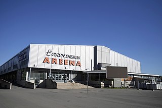
Oulun Energia Areena, also called Oulun jäähalli and previously Raksilan jäähalli, is an ice sport arena in the Raksila Sports Centre, located in the Raksila district of Oulu, Finland. The venue is operated by the City of Oulu.

The Rotuaari is a pedestrian zone in the Pokkinen district in Oulu, Finland. The area, together with the Oulu Market Square, is being managed by the city centre shopkeeper association Oulun Liikekeskus ry.

Tuira is a district of the city of Oulu, Finland. It is located north of city centre across the Oulujoki River. After the first bridges over Oulujoki connecting Tuira with Oulu were built in 1869, population growth of Tuira accelerated and Tuira was annexed by city of Oulu from the neighbouring rural municipality in 1886. Until the 1970s Tuira was a neighbourhood of wooden townhouses, but the new zoning plan of 1969 changed it to a suburb of residential tower blocks.

Pikisaari is a district of the city of Oulu, Finland. The district consists of Pikisaari and Korkeasaari islands connected due to the post-glacial rebound. Pikisaari is located near the city centre in the estuary of Oulujoki River in between market square and Hietasaari island.

Myllytulli is a district of the city centre area of Oulu, Finland.

Intiö is a district of the city centre area of Oulu, Finland. It is located on the southern bank of the Oulu River in between Myllytulli and Värttö districts.

Raksila is a District of the city centre area of Oulu, Finland. It is bounded by the Oulu railway station to the west, the Oulu Cemetery in the Intiö district to the north, the Finnish national road 4 to the east and the Finnish national road 22 to the south.

Linnanmaa is a district of the Kaijonharju area of Oulu, Finland. The district is located about five kilometers north of the city centre.

Hietasaari is district in the Tuira area in the city of Oulu, Finland. The district consists of Mustasaari and Hietasaari islands, separated by the Mustasalmi strait, together with some smaller islands. Hietasaari is zoned as recreation area with only few people living in the district permanently.
Pokkinen is a district of the city centre area of Oulu, Finland. Together with districts of Vaara and Vanhatulli, Pokkinen forms the central business district of Oulu. It is bounded by the estuary of the Oulujoki river to the west, the Koskikeskus and Myllytulli districts to the north, the Vaara district to the east and the Vanhatulli district to the south.

Vanhatulli is a district of the city centre area of Oulu, Finland. Together with the districts of Pokkinen and Vaara, Vanhatulli forms the central business district of Oulu. It is bounded by the estuary of the Oulujoki river to the west, the Pokkinen and Vaara districts to the north, the Leveri and Hollihaka districts to the south and the railway to the east.
Vihreäsaari is an uninhabited island and a neighbourhood in the Tuira area in the city of Oulu, Finland. It is separated from the Hietasaari island by the Johteensalmi strait.

Haukipudas is a district of Oulu, Finland. Together with Jokikylä and Martinniemi districts, it forms the Haukipudas area. Haukipudas is located in the river delta of the Kiiminkijoki river. It is bounded by the Bothnian Bay in the west, National road 4 in the east, Martinniemi district in the north and Kello district in the south. The district was established in 2013 when the Haukipudas municipality together with Kiiminki, Oulunsalo and Yli-Ii municipalities were merged with the city of Oulu.

Kiiminki is a district of Oulu, Finland. Together with Alakylä, Hannus and Huttukylä districts, it forms the Kiiminki area. The center of the district is located where the National road 20 crosses the Kiiminkijoki river. The district was established in 2013 when the Kiiminki municipality together with Haukipudas, Oulunsalo and Yli-Ii municipalities were merged with the city of Oulu.

Kontinkangas is a district of Oulu, Finland. It is located to the east of the National road 4 and to the north of the National road 22 about two kilometers from the city centre. Its neighbouring districts are Kaukovainio, Raksila, Peltola and Oulunsuu.

Karjasilta is a district in the Höyhtyä area in the city of Oulu, Finland. The district close to the city centre is bordered by the Raksila district to the north, Finnish national road 4 to the east, the Vanhatulli and Limingantulli districts to the west and the Nokela and Höyhtyä districts to the south.

Martinniemi is a district of Oulu, Finland. Together with Haukipudas and Jokikylä districts, it forms the Haukipudas area. Martinniemi is located in north of the river delta of the Kiiminkijoki river. It is bounded by the Bothnian Bay in the west, the Jokikylä district in the east, the Ii municipality in the north and the Kiiminkijoki river and the Haukipudas district in the south. The district was established in 2013 when the Haukipudas municipality together with Kiiminki, Oulunsalo and Yli-Ii municipalities were merged with the city of Oulu.

The Oulu Bus Station is a bus station in the city center of Oulu, Finland, located in the Vaara district near the Raksila district. From the bus station there is a pedestrian connection via the railway underpass tunnel to Oulu railway station and the station pier. There is no longer a ticket office and the Matkahuolto service in the station building, but there is still a café in the building.
