
Tirupati is a city in the Indian state of Andhra Pradesh. It is the administrative headquarters of the Tirupati district. The city is home to the important Hindu shrine of Tirumala Venkateswara Temple and other historic temples and is referred to as the "Spiritual Capital of Andhra Pradesh". It is located at a distance of 150km from Chennai and 250km from Bangalore and 415km from Amaravati. It is one of the eight Swayam vyaktha kshetras dedicated to Vishnu. Tirupati is a municipal corporation and the headquarters of Tirupati (urban) mandal, Tirupati (rural) mandal, and the Tirupati revenue division.

Chittoor district is one of the eight districts in the Rayalaseema region of the Indian state of Andhra Pradesh. The district headquarters is located at Chittoor. It has a population of 4,170,468 according to 2011 census of India. It lies in the Poini River Valley of southernmost Andhra Pradesh along the Chennai–Bangalore section of Chennai-Mumbai highway. Chittoor district is a major market centre for mangoes, grains, sugarcane, and peanuts.
Narayanavanam is a census town in Tirupati district of the Indian state of Andhra Pradesh. It is the headquarters of Narayanavanam mandal in Sri Kalahasti revenue division. The town is known for Kalyana Venkateswara Temple dedicated to Lord Venkateswara and constructed in 1541 AD.

Srikalahasti is a holy town in Tirupati district of the Indian state of Andhra Pradesh. It is a municipality and the revenue division of Srikalahasti mandal & Srikalahasti revenue division. It is a part of Tirupati Urban Development Authority, which is located on the banks of the River Swarnamukhi.

Pakala is a town in Tirupati district of the Indian state of Andhra Pradesh. It is the mandal headquarters of Pakala mandal. It comes under Tirupati revenue division.
Chejerla is a village and a Mandal in Nellore district in the state of Andhra Pradesh in India.
Tirupati (rural) mandal is one of the 34 mandals in Tirupati district of Andhra Pradesh in India. It has its headquarters at Tirupati (rural) town. The mandal is bounded by Chandragiri mandal, Tirupati (urban) mandal, Renigunta mandal, Kammapalle mandal and Vadamalapeta mandal.
Buchinaidu Kandriga mandal or B. N. Kandriga mandal is one of the 34 mandals in Tirupati district of the Indian state of Andhra Pradesh. The mandal headquarters are located at Kanamanambedu. The mandal is bounded by Varadaiahpalem, K.V.B. Puram, Thottambedu mandals.

Nagalapuram is a Mandal Headquarter in Tirupati district of the Indian state of Andhra Pradesh. It is the mandal headquarters of Nagalapuram mandal in Srikalahasti revenue division. This town is home to Vedanarayana Temple, where the presiding deity Vishnu is in the form of Matsya, the first incarnation of Dasavatara.
Tirupati (urban) mandal is one of the 34 mandals in Tirupati district of the Indian state of Andhra Pradesh. It has its headquarters at Tirupati city&Tirupati district. The mandal is bounded by Chandragiri, Tirupati (rural) mandals. A part of it also borders Annamayya district.

Yerpedu is a place situated in Tirupati district of the Indian state of Andhra Pradesh. It is a part of Tirupati suburb and is located near Sri Kalahasti. It falls in the jurisdictional limit of Tirupati Urban Development Authority. It is the mandal headquarters of Yerpedu mandal.
Talakona is situated in Tirupati district of Andhra Pradesh, India. It is a resort with waterfalls, dense forests and wildlife. Talakona waterfall is in Sri Venkateswara National Park, Tirupati district of Andhra Pradesh. With a 270 feet (82 m)-fall, Talakona is the highest waterfall in Andhra Pradesh state. Talakona is also known for the Lord Siddheswara Swamy Temple, which is located close to the waterfall.
Renigunta mandal is one of the 34 mandals in Tirupati district of the Indian state of Andhra Pradesh. Its headquarters are located at Renigunta. The mandal is bounded by Tirupati (urban), Tirupati (urban), Vadamalapeta, Yerpedu.This mandal is located at Srikalahasti revenue division.
Gudur mandal is one of the 34 mandals in Tirupati district of the state of Andhra Pradesh, India. Its headquarters are located at Gudur. The mandal is situated on the coast of Bay of Bengal, bounded by Sydapuram, Manubolu, Balayapalle, Ojili and Chillakur mandals. It is a part of Gudur revenue division.
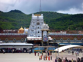
Tirupati district is one of the twenty-six districts in the Indian state of Andhra Pradesh and one of the eight districts in the Rayalaseema region of the Andhra Pradesh state. The district headquarters is located at Tirupati city. Tirupati district is known for its numerous historic temples, including the Hindu shrine of Tirumala Venkateswara Temple, Sri Kalahasteeswara temple and many others. The district is also home to Satish Dhawan Space Centre, a rocket launch centre located in Sriharikota and operated by Indian Space Research Organisation (ISRO). The river Swarnamukhi flows through Srikalahasti and joins with the Bay of Bengal in this district. Industries include groundnuts and paddy fields. The district is an educational hub and has central and state universities and institutes including IIT Tirupati, Sri Venkateswara University, National Sanskrit University, IISER Tirupati. The district is home to Sri City, one of the leading special economic zone (SEZ) in India with total investments of 4 billion USD and over two hundred companies from 28 countries.
Vadamalapeta mandal is one of the 34 mandals in Tirupati district of Andhra Pradesh in India. It has its headquarters at Vadamalapeta village and is part of Tirupati revenue division.
Vakadu mandal is one of the 34 mandals in Tirupati district in the Indian state of Andhra Pradesh. It is a part of Gudur revenue division.
Venkatagiri mandal is one of the 34 mandals in Tirupati district in the Indian state of Andhra Pradesh. It is a part of Gudur revenue division.
Doravarisatram mandal is one of the 34 mandals in Tirupati district in the Indian state of Andhra Pradesh. It is a part of Sullurupeta revenue division.
Narayanavanam mandal is one of the 34 mandals in Tirupati district in the Indian state of Andhra Pradesh. It is administered as a part of Srikalahasti revenue division.

