
Valle Gesso is a valley in the Maritime Alps (south-western Alps), located in the Italian province of Cuneo and crossed by the Gesso torrent.
Contents
The language spoken by the inhabitants belongs to the Occitan language family. [1]
Valle Gesso is a valley in the Maritime Alps (south-western Alps), located in the Italian province of Cuneo and crossed by the Gesso torrent.
The language spoken by the inhabitants belongs to the Occitan language family. [1]
The valley is home to the highest peaks in the range, those of Monte Argentera (3,297 m). Its territory is divided between the municipalities of Entracque, Roaschia, Valdieri and Roccavione. Nearby valleys include the Valle Vermenagna, the Tinée valley in France and the Valle Stura di Demonte. After Valdieri, the valleys divided into two sub-valleys known as Valle Gesso di Entracque and Valle Gesso della Valletta.
Historically, the valley was inhabited by the Ligures, who were defeated by the Romans in 14 BC. After the fall of the Roman empire, around 600, the Benedictines founded here the Abbey of Pedona, which controlled the valley until emperor Louis I gave it to the bishops of Asti in 901. In the 13th century, after a short period under the Marquisate of Saluzzo, it was acquired by the Angevines, who had created a county in Piedmont with Cuneo as its capital.
After the 14th century it became a fief of the Duchy of Savoy, to which it belonged until the 19th century, aside from a short French rule after the French Revolutionary Wars. The Savoy family created here a resort and a personal hunting reserve, which later became the Maritime Alps Natural Park. As a part of the Kingdom of Italy from 1861, the valley remained economically based on animal husbandry and agriculture; after World War II the presence of hydro-electric plant favored the creation of industries (especially cement plants), while tourist became increasingly relevant starting from the 1980s.

Piedmont is a region of Northwest Italy, one of the 20 regions of Italy. It borders the Liguria region to the south, the Lombardy and Emilia-Romagna regions to the east, and the Aosta Valley region to the northwest; it also borders Switzerland to the north and France to the west. It has an area of 25,402 km2 (9,808 sq mi) making it the second largest region of Italy after Sicily; as of 31 January 2021, the population was 4,269,714. The capital of Piedmont is Turin, which was also the capital of the Kingdom of Italy from 1861 to 1865.

The Cottian Alps are a mountain range in the southwestern part of the Alps. They form the border between France and Italy (Piedmont). The Fréjus Road Tunnel and Fréjus Rail Tunnel between Modane and Susa are important transportation arteries between France and Italy (Turin).

The Aosta Valley is a mountainous autonomous region in northwestern Italy. It is bordered by Auvergne-Rhône-Alpes, France, to the west, Valais, Switzerland, to the north, and by Piedmont, Italy, to the south and east. The regional capital is Aosta.
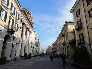
Cuneo is a city and comune in Piedmont, Italy, the capital of the province of Cuneo, the fourth largest of Italy’s provinces by area.

Northern Italy is a geographical and cultural region in the northern part of Italy. It consists of eight administrative regions: Aosta Valley, Emilia-Romagna, Friuli-Venezia Giulia, Piedmont, Liguria, Lombardy, Veneto and Trentino-Alto Adige. As of 2014, its population was 27,801,460. Rhaeto-Romance and Gallo-Italic languages are spoken in the region, as opposed to the Italo-Dalmatian languages spoken in the rest of Italy. The Venetian language is sometimes considered to be part of the Italo-Dalmatian languages, but some major publications such as Ethnologue and Glottolog define it as Gallo-Italic.

The Marquisate of Saluzzo was a historical Italian state that included parts of the current region of Piedmont and of the French Alps. The Marquisate was much older than the Renaissance lordships, being a legacy of the feudalism of the High Middle Ages.

Tende is a commune in the Alpes-Maritimes department in southeastern France.

Barge is a comune (municipality) in the Province of Cuneo in the Italian region Piedmont, located about 50 kilometres (31 mi) southwest of Turin and about 45 kilometres (28 mi) northwest of Cuneo. The population numbered 7,589 as of 30 November 2019.

Borgo San Dalmazzo is a comune (municipality) in the Province of Cuneo in the Italian region Piedmont, located about 80 kilometres (50 mi) south of Turin and about 8 kilometres (5 mi) southwest of Cuneo.

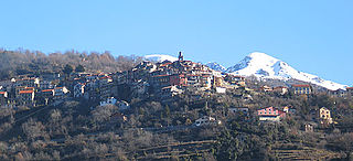
Entracque is a small town in the Valle Gesso of the Maritime Alps of north-west Italy, about 20 kilometres (12 mi) southwest of Cuneo and close to the French border. It is the principal settlement and capoluogo of the comune or municipality of the same name in the Piedmontese Province of Cuneo.
Valdieri is a comune (municipality) in the Province of Cuneo in the Italian region Piedmont, located about 90 kilometres (56 mi) southwest of Turin and about 15 kilometres (9 mi) southwest of Cuneo, on the border with France. It is part of the Valle Gesso.

The County of Nice is a historical region of France located around the southeastern city of Nice and roughly equivalent to the modern arrondissement of Nice.

Italian irredentism in Nice was the political movement supporting the annexation of the County of Nice to the Kingdom of Italy.

The Maira is an Italian river, a right tributary of the Po, which runs through the province of Cuneo in eastern Piedmont. Its source is in the Cottian Alps near the Col de Mary on the French border. Its name, in the Occitan and Piedmontese languages, means ‘lean’ or ‘meagre’.
Belvédère is a commune in the Vésubie valley north of Nice in the Alpes-Maritimes department in southeastern France. The village of Belvédère is located at the entrance of the Gordolasque valley on the edge of the Mercantour National Park.
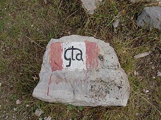
The Grande Traversata delle Alpi (GTA) is a long-distance hiking trail in the Italian region of Piedmont. In about 1,000 kilometres (620 mi) and 55 day hikes, it runs through the arc formed by the western Alps from the Pennine Alps through the Graian and Cottian Alps to the Maritime and Ligurian Alps. There are a number of transverse valleys along the route. Day hikes typically connect high-lying valley communities with each other via historic pass routes.

Monte Argentera is a mountain in the Maritime Alps, in the province of Cuneo, Piedmont, northern Italy. With an elevation of 3,297 metres (10,817 ft), it is the highest peak in the range.

The Exilles Fort is a fortified complex in the Susa Valley, Metropolitan City of Turin, Piedmont, northern Italy. Together with the nearby Fort of Fenestrelle and the Forte Albertino it was part of the defensive line between the House of Savoy lands and France: both these states held it in different phases depending on the outcome of the various wars. It is located on a spur commanding one of the narrowest sections of the Susa Valley, along the main road connecting Turin to France.

The Italian geographic region, Italian physical region or Italian region is a geographical region of south-central Europe delimited to the north by the mountain chains of the Alps. This subregion is composed of a peninsular and continental part and an insular part. Located between the Balkan Peninsula and the Iberian Peninsula, it protrudes into the centre of the Mediterranean Sea and overlooks the Adriatic Sea, the Ionian Sea, the Ligurian Sea, the Sardinian Channel, the Sea of Corsica, the Sea of Sardinia, the Strait of Sicily, and the Tyrrhenian Sea.
Dante Livio Bianco achieved early distinction among legal professionals as an exceptionally able Italian civil lawyer, and then came to wider prominence as a wartime partisan leader. He was awarded the Silver Medal of Military Valor twice. He survived the war but nevertheless died at a relatively young age due to a climbing accident.
| Authority control: National |
|---|