
Belmopan is the capital city of Belize. Its population in 2010 was 16,451. In addition to being the smallest capital city in the continental Americas by population, Belmopan is the third-largest settlement in Belize, behind Belize City and San Ignacio. Founded as a planned community in 1970, Belmopan is one of the newest national capital cities in the world. Since 2000, Belmopan has been one of two settlements in Belize to hold official city status, along with Belize City.

Demographics of the population of Belize include population density, ethnicity, education level, health of the populace, economic status, religious affiliations and other aspects.

Benque Viejo del Carmen ("Benque") is the westernmost town in Belize, 130 km (81 mi) by road west and south of Belize City, at the Guatemalan border. San Ignacio lies 13 km to the east and Melchor de Mencos just across the border. The Mopan River runs along the town's north and west edges.

Toledo District is the southernmost and least populated district in Belize. Punta Gorda is the District capital. According to the Human Development Index (HDI), it is the second most developed region in the country. The district has a diverse topography which features rainforests, extensive cave networks, coastal lowland plains, and offshore cays. Toledo is home to a wide range of cultures such as Mopan, Kekchi Maya, Creole, Garifuna, East Indians, Mennonites, Mestizos, and descendants of US Confederate settlers.
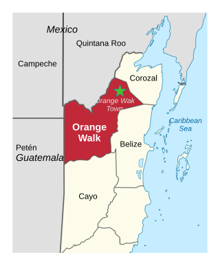
Orange Walk District is a district in the northwest of the nation of Belize, with its district capital in Orange Walk Town.

Cayo District is located in the west part of Belize, and it contains the capital, Belmopan. It is the most extensive, second-most populous and third-most densely populated of the six districts of Belize. The district's capital is the town of San Ignacio.

Spanish Lookout is a settlement in the Cayo District of Belize in Central America. According to the 2010 census, Spanish Lookout had a population of 2,253 people in 482 households. Spanish Lookout is a community of Mennonites.
Roaring Creek is a small village in the Cayo District of Belize, just north-west of Belmopan. Its name is derived from the creek waterfalls which flow into the Belize River next to the Guanacaste Park area.

Christianity is the dominant religion in Belize. The single largest denomination is the Catholic Church with about 40.1% of the population, a reduction from 49.6% of the population in 2000, 57.7% in 1991 and 61.9% in 1980, although absolute numbers have still risen. Other major groups include Pentecostal with 8.4% of the population up from 7.4% in 2000 and 6.3% in 1991, Seventh-day Adventists with 5.4% of the population up from 5.2% in 2000 and 4.1% in 1991. The following of the Anglican Church has been steadily declining, with only 4.7% of the population in 2010 compared to 6.95% in 1991. About 12,000 Mennonites live mostly in the rural districts of Cayo and Orange Walk. People who declared they belong to no religion make up 15.5% of the population in 2010, more than double their 2000 census numbers. 11.2% adhere to other religions which include the Maya religion, Afro-Caribbean religions, Mormons, Hindus, Buddhists, Muslims, Baháʼís, Rastafarians and others.
Armenia is a village in the Cayo District of Belize, along the nation's Hummingbird Highway south of the capitol, Belmopan.
Burrell Boom is on the Belize River twenty miles above Belize City, Belize. Tourists pass through this historic village on their way to the Community Baboon Sanctuary, where the population of black howler monkeys has grown to over 2,000.
La Democracia is a populated settlement located in the nation of Belize. It is a mainland village that is located in Belize District.
Pook's Hill is a private forest reserve, bird sanctuary, and archaeological site in Cayo District, Belize, 12 miles (19 km) west of Belmopan. The Mayan site contains temples, a plazuela, midden, banquet hall, and burial sites. Facilities within the reserve include Pook's Hill Lodge, an ecotourism resort.

Pacbitun is a Maya archaeological site located near the town of San Ignacio, Belize, in the Cayo District of west central Belize. The modern Maya name given to the site means “stone set in earth”, likely a reference to multiple fragments of stone monuments. The site, at about 240 m above sea level, is one of the earliest known from the southern Maya Lowlands, and was inhabited for almost 2000 years, from ca. 900 BCE to 900 CE. Strategically, it straddles a territory of rolling, hilly terrain between the Mountain Pine Ridge and the tropical forest covered lowlands of the Upper Belize River Valley.
Camalote is a village located along the George Price Highway in Cayo District, Belize. It lies approximately five kilometers west of Belmopan.
More Tomorrow is a small village located along the Belize River in Cayo District, Belize. It is the oldest recognized village in the country of Belize, being over 266 yrs old. It was originally used as a trading post along the Belize River for travelers transporting goods from Guatemala to Belize City, and then out to the Caribbean. It is approximately 5 miles from the George Price Highway, and about 20 minutes from Belmopan, the capital of Belize.
Lower Dover is a Maya archaeological site in the Belize River Valley. It is located on the grounds of the Lower Dover Field Station & Jungle Lodge, in Unitedville, Cayo District, Belize. The site is bordered by the Belize River to the north, Upper Barton Creek to the west, Lower Barton Creek to the east, and the Western Highway to the south. Lower Dover is one of several Maya archaeological sites in the area; it is across the Belize River from Barton Ramie, 3 kilometers west of Blackman Eddy, and 6 kilometers east of Baking Pot.
Unitedville village is a village located Cayo District, Belize. Unitedville is home to 974 persons with the main ethnic groups being Creoles the most numerous and seconded by the Mestizos. The main livelihood activity in this community is traditionally subsistence farming. Residents produce much of their own food, such as corn, ground food, beans, some rice, various tropical fruits, chickens and small livestock. Surplus production was sold. All members of the family generally participate in this activity. Thus, the families develop strong, united relationships. Unitedville is closer to San Ignacio, as opposed to Belmopan, and as such the villagers shop and recreate in that town rather than in the capital. Villagers of Unitedville relate to Belmopan mainly for administrative services. Recently, there is an increasing trend in the number of younger members of the village engaged in the fields of construction and the public service.

Cotton Tree is a village in the Cayo District of central interior Belize. The village is situated 5km to the northeast of Belmopan along the Western Highway. The surrounding area is agricultural with the most frequent crops being citrus and banana. It is one of 192 municipalities administered at the village level in the country for census taking purposes.

