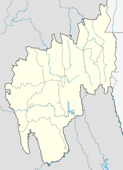
Tripura is a state in northeastern India. The third-smallest state in the country, it covers 10,491 km2 (4,051 sq mi); and the seventh-least populous state with a population of 3.67 million. It is bordered by Assam and Mizoram to the east and by Bangladesh to the north, south and west. Tripura is divided into 8 districts and 23 sub-divisions, where Agartala is the capital and the largest city in the state. Tripura has 19 different tribal communities with a majority Bengali population. Bengali, English and Kokborok are the state's official languages.

Agartala is the capital and the largest city of the Indian state of Tripura, situated on the banks of Haora/Saidra River, about 2 kilometres (1.2 mi) east of the border with Bangladesh and about 2,499 km (1,552 mi) from the national capital, New Delhi. According to 2022 AMC data, Agartala is the second most populous city after Guwahati in Northeast India. It is India's third international internet gateway and being developed under the Smart Cities Mission.

Northeast India, officially the North Eastern Region (NER), is the easternmost region of India representing both a geographic and political administrative division of the country. It comprises eight states—Arunachal Pradesh, Assam, Manipur, Meghalaya, Mizoram, Nagaland and Tripura, and the "brother" state of Sikkim.

Shillong is a hill station and the capital of Meghalaya, a state in northeastern India. It is the headquarters of the East Khasi Hills district. Shillong is the 330th most populous city in India with a population of 143,229 according to the 2011 census. It is said that the rolling hills around the town reminded the British of Scotland. Hence, they would refer to it as the "Scotland of the East".

The Insurgency in Northeast India involves multiple separatist and jihadist militant groups operating in some of India's northeastern states, which are connected to the rest of India by the Siliguri Corridor, a strip of land as narrow as 14.29 miles (23.00 km) wide.

New Jalpaiguri Junction railway station established in 1960, is an A1 category broad-gauge and narrow-gauge railway station under Katihar railway division of Northeast Frontier Railway zone. It is the largest and the busiest railway junction of northern Bengal. This junction is largest among the railway stations which serve the city of Siliguri, the largest metropolis of the North Bengal. The other stations are- Siliguri Junction, Gulma, Bagdogra, Matigara, Rangapani and Siliguri Town. New Jalpaiguri junction ranked 10th cleanest railway station in India in 2016 survey and came among the top 100 booking stations of Indian railway. New Jalpaiguri, as a railway station serves as the entry point to North Bengal, Sikkim, other countries like Nepal, Bhutan, Bangladesh and the seven northeastern states. New Jalpaiguri Junction acts as a connecting base of railways for the northeastern states to the Indian mainland.

The Tripura Baptist Christian Union (TBCU) is a Baptist Christian denomination in Tripura, India. It has its head office in Agartala, the state capital. The TBCU is affiliated to the Asia Pacific Baptist Federation (APBF) and the Baptist World Alliance (BWA). It is also a member church of the North East India Christian Council (NEICC), a regional church body of the National Council of Churches in India (NCCI).
The administrative divisions of India are subnational administrative units of India; they are composed of a nested hierarchy of administrative divisions.
Belonia is a town and municipal council in South Tripura district, Tripura, India. It is also the headquarters of South Tripura District. It is linked with Agartala by National Highway 108A from Belonia to Jolaibari and via National Highway 8 from Jolaibari to Agartala. Belonia lies on the border with Bangladesh.

Betlingchhip, also known as Betalongchhip, Balinchhip and Thaidawr is the highest peak of the Jampui Hills. It is located in the state of Tripura.

Pradyot Manikya Deb Barma is the current titular King (Maharaja) and statesman from Tripura. He was born in New Delhi, and now resides in Agartala, Tripura. He also served as the editor of TNT-The Northeast Today. He is the current chairman of The Indigenous Progressive Regional Alliance also known as TIPRA Motha. He is known as 'Bubagra' among his people and is one of the active voices for the rights of Indigenous Tripuri people of Tripura.

Unakoti famously known as Angkor Wat of the North-East, is a sculptural emblem and ancient Shaivite place that hosts rock carvings, figures and images of gods and goddesses. It is a place of worship with huge rock reliefs celebrating Shiva. Unakoti literally means "one less than one crore" or "koti" in Hindi. In the local Kokborok language, it is called Subrai Khung. It was put on the UNESCO world heritage site tentative list in 2022. It is the prime tourist spot of Unakoti District, in the Kailashahar Subdivision of the North-eastern Indian state of Tripura.

Agartala Railway Station is located 5.5 km (3.4 mi) from Agartala in Tripura, India. It is the second capital city in northeast India to be connected to the country's railway map, moreover Agartala is the first state capital of independent India to be connected with a rail network. Before 2015 the 413-kilometre (257 mi) route was connected to Lumding with a metre-gauge track, but after the gauge conversion to broad gauge in 2016, the track is connected directly to Guwahati and the rest of India.

Northeast India consists of eight states: Arunachal Pradesh, Assam, Manipur, Meghalaya, Mizoram, Nagaland, Sikkim and Tripura. Tourism in this area is based around the unique Himalayan landscape and culture distinct from the rest of India.

Sabual is a village in the northeastern part of Tripura state in Northeast India. It is one of the ten Mizo-Reang villages which compose the Jampui Hills range under Kanchanpur Sub-Division. The District headquarter, Dharmanagar is approximately 85 kilometers from Sabual. It sits at about 1000 meters above sea level. Summer is cool and winter season is cold. The economy of the village depend on shifting cultivation and Gardening.

The Republic of India shares borders with several sovereign countries; it shares land borders with China, Bhutan, Nepal, Pakistan, Bangladesh, and Myanmar. Bangladesh, Myanmar, and Pakistan share both land borders as well as maritime borders, while Sri Lanka shares only a maritime border through Ram Setu. India's Andaman and Nicobar Islands share a maritime border with Thailand, Myanmar, and Indonesia.

Biplab Kumar Deb is an Indian politician from Bharatiya Janata Party serving as Member of Parliament from Tripura West. He served as the Member of Rajya Sabha from Tripura from 2022 to 2024. He also served as the 10th Chief Minister of Tripura from 2018 to 2022. He was the first Chief Minister of Tripura from the Bharatiya Janata Party. He was the member of the Tripura Legislative Assembly from Banamalipur constituency from 2018 to 2022. He was also the president of the Bharatiya Janata Party's Tripura unit from 2016 to 2018.

Shikdamakha is a village in the West Karbi Anglong district of Assam state in North East India. It falls under the Amri development block and Vidhan Sabha No.20 Baithalangso ST LAC.

The Mizo people in Tripura are an ethnic minority in the northeast Indian state. They have established settlements in areas like the Jampui Hills and integrated into Tripura's socio-cultural landscape.


