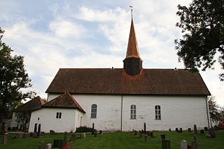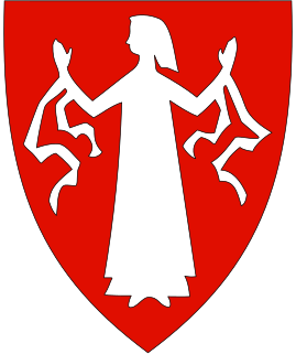
Varteig is a village in Sarpsborg and a former municipality in Østfold County, Norway. [1]

Varteig is a village in Sarpsborg and a former municipality in Østfold County, Norway. [1]

Varteig is located north of the city of Sarpsborg and east of the Glomma river. Varteig was part of the Tune municipality until 1861. It was designated to be a municipality by a split from Tune in 1861. At that time Varteig had a population of 1,405. On 1 January 1992 a small part of the district Furuholmen, with 12 inhabitants, was moved to Rakkestad municipality. The rest of Varteig was incorporated into Sarpsborg along with Tune and Skjeberg.
Varteig is probably best known as the home place of Inga of Varteig (born about 1185, died 1234), mother of Håkon Håkonson, king of Norway from 1217 to 1263. [2]
The municipality (originally parish) is named after the farm of Varteig (Old Norse Varteigr). Varteig Church (Varteig kirke) was first built on its ground. The meaning of the first element is unknown, the last element is teigr m 'strip of field'. [3]

Sarpsborg, historically Borg, is a city and municipality in Viken county, Norway. The administrative centre of the municipality is the city of Sarpsborg.

Sørum was a municipality in Akershus county, Norway. It is part of the traditional region of Romerike. The administrative centre of the municipality was the village of Sørumsand. Sørum was established as a municipality on 1 January 1838. The municipality of Blaker was merged with Sørum on 1 January 1962.

Krødsherad is a municipality in Viken county, Norway. The administrative centre of the municipality is the village of Noresund. The municipality of Krødsherad was established when it was separated from the municipality of Sigdal on 1 January 1901.

Hurum was a municipality in Buskerud county, Norway. As of 1 January 2020 Hurum has merged with the municipalities of Røyken and Asker to form the new Asker Municipality located in the newly formed Viken county. The administrative centre of the municipality is the village Sætre. The municipality of Hurum was established on 1 January 1838. The small village of Holmsbu was granted town status in 1847, but it did not become a municipality of its own. It lost its town status on 1 January 1964.

Kråkstad is a village and former municipality located in Ski municipality in Viken, Norway.
Ullerøy is a peninsula and urban area in the municipality of Sarpsborg in Østfold, Norway. As of 2009, the population was 363. Before 1992 Ullerøy was a part of Skjeberg municipality.
Brunlanes is a parish and former municipality within Larvik municipality in Vestfold county, Norway. It was annexed by Larvik on January 1, 1988.

Ytre Sandsvær is a former municipality in Buskerud county, Norway.

Idd is a parish and former municipality in Halden, Østfold county, Norway.

Skjeberg is a district of Sarpsborg, Østfold County, Norway. Skjeberg was formerly a municipality in Østfold County. The last administrative centre was at Borgenhaugen. As of 2018, Skjeberg has a population of 1,397.

Borge is a parish and former municipality in Østfold county, Norway. Today it is located in the northeast part of Fredrikstad municipality, near the border with Sarpsborg.

Norderhov is a former municipality located within Ringerike in Buskerud county, Norway.

Tune is a former municipality in Østfold county, Norway. The former municipality originally covered the current Sarpsborg municipality with the exception of Skjeberg and with the addition of Rolvsøy.

Efteløt is a small village in Kongsberg municipality, Buskerud, Norway.

Slemmestad is a village in Røyken in Asker municipality in Viken, Norway. Slemmestad is located on the west bank of the Oslofjord, west of Oslo.

Tranby is a village in Lier municipality in Viken, Norway.

Tanum is a parish and district in the municipality of Bærum in Akershus, Norway. Its population (2007) is 2,751.

Åssiden is the largest borough of Drammen in Buskerud county, Norway.

Inga Olafsdatter of Varteig was the mistress of King Haakon III of Norway and the mother of King Haakon IV of Norway.

Henrik Greve Hille was a Norwegian clergyman. He served as Bishop of the Diocese of Hamar from 1934 to 1942 and again from 1945 until 1946.
Coordinates: 59°21′02″N11°11′25″E / 59.35056°N 11.19028°E