
Ithaca, Ithaki or Ithaka is a Greek island located in the Ionian Sea, off the northeast coast of Kefalonia and to the west of continental Greece.
Kefalonia or Cephalonia, formerly also known as Kefallinia or Kephallenia (Κεφαλληνία), is the largest of the Ionian Islands in western Greece and the 6th largest island in Greece after Crete, Euboea, Lesbos, Rhodes and Chios. It is also a separate regional unit of the Ionian Islands region. It was a former Latin Catholic diocese Kefalonia–Zakynthos (Cefalonia–Zante) and short-lived titular see as just Kefalonia. The capital city of Cephalonia is Argostoli.
The Ionian Islands are a group of islands in the Ionian Sea, west of mainland Greece. They are traditionally called the Heptanese, but the group includes many smaller islands in addition to the seven principal ones.

Zakynthos or Zante is a Greek island in the Ionian Sea. It is the third largest of the Ionian Islands, with an area of 405.55 km2 (156.6 sq mi), and a coastline 123 km (76 mi) in length. The name, like all similar names ending in -nthos, is pre-Mycenaean or Pelasgian in origin. In Greek mythology the island was said to be named after Zacynthus, the son of the legendary Arcadian chief Dardanus.

Argostoli is a town and a municipality on the island of Kefalonia, Ionian Islands, Greece. Since the 2019 local government reform it is one of the three municipalities on the island. It has been the capital and administrative centre of Kefalonia since 1757, following a population shift down from the old capital of Agios Georgios, also known as Kastro, to take advantage of the trading opportunities provided by the sheltered bay upon which Argostoli sits.
Markopoulo is a village and a community in the southeastern part of the island of Cephalonia, Greece. It is situated at the southeastern foot of Mount Ainos, at about 250 m elevation. The community consists of the villages Markopoulo, Kateleios and the beach village Kato Kateleios. Markopoulo is located 1 km east of Chionata, 2 km west of Kateleios, 2 km northwest of Kato Kateleios, 6 km west of Skala and 9 km southwest of Poros.
Pastra is a village and a community in the southeastern part of the island of Kefalonia, Greece. It was the seat of the municipality of Eleios-Pronnoi. The community consists of the villages Pastra and Kremmydi. Pastra is 2 km northeast of Markopoulo, 3 km south of Agia Eirini, 5 km northwest of Skala, 6 km southwest of the port town of Poros and 25 km southeast of Argostoli.
Tzanata is an inland village in the southeast of Kefalonia, one of the Ionian Islands of Greece. It is part of the community of Poros within the Eleios-Pronnoi municipal unit. It is situated 3 km southwest of Poros, 25 km southeast of Sami and 36 km east of Argostoli.
Vlachata is a village and a community in the eastern part of the municipal unit of Leivatho near the south coast of the island of Kefalonia, Greece. To avoid confusion with another Vlachata near Sami, it is also known as Vlachata Eikosimias. The community consists of the villages Vlachata and Simotata, which is 2 km east of Vlachata. Vlachata is situated on a mountain slope above the Ionian Sea coast, at about 200 m elevation. Mount Ainos, the highest point of Cephalonia, is 4 km to the northeast. Vlachata is 1 km northwest of Lourdata, 2 km southeast of Mousata, 13 km southwest of Poros and 13 km southeast of Argostoli. The road from Argostoli to Poros runs through Vlachata. Vlachata suffered great damage from the 1953 Ionian earthquake.

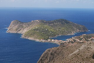
Poros is a picturesque small town located in the municipal unit of Eleios-Pronnoi, some 40 km SE of Argostoli, 28 km SE of Sami and 12 km NE of Skala, in the southeast of Cephalonia, one of the Ionian Islands of Greece.
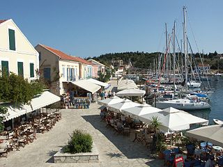
Fiskardo is a village and a community on the Ionian island of Kefalonia, Greece. It is part of the municipal unit of Erisos. It is the northernmost port of Kefalonia, a short distance from Ithaca. Fiskardo has a small and diminishing fishing fleet. The coast around Fiskardo is mainly rocky with numerous pebble-beached coves. The port serves ferry routes to the ports of Frikes (Ithaca) and Lefkada. It is 5 km north of Vasilikades, 24 km north of Sami and 32 km north of Argostoli. Cephalonia International Airport is 61 km to the south, by road. The community of Fiskardo consists of the villages Fiskardo, Evreti, Katsarata, Matsoukata and Tselentata.

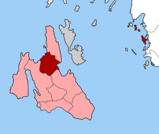
Paliki is a peninsula and a former municipality on the island of Kefalonia, Ionian Islands, Greece. At the 2011 local government reform it became part of the municipality Kefalonia. In 2019 this municipality was divided into three municipalities, and the municipal unit Paliki became the only municipal unit of the new municipality Lixouri. The municipal unit has an area of 119.341 km2. The name comes from the ancient town of Pale/Pali, which was north of Lixouri and is now an archaeological site. The peninsula is the westernmost part of Kefalonia. The seat of the municipality was the town Lixouri (3,752).
Skala is a village located in the municipal unit of Eleios-Pronnoi, some 39 km south from the island's main town of Argostoli and 14 km SW of Poros, in the south of Cephalonia, one of the Ionian Islands of Greece.

Lixouri is a town and a municipality in the island of Kefalonia, the largest of the Ionian Islands of western Greece. It is the main town on the peninsula of Paliki, and the second largest town in Kefalonia after Argostoli and before Sami. It is located south of Fiskardo and west of Argostoli. Since the 2019 local government reform it is one of the three municipalities on the island. It has one municipal unit: Paliki.
Pylaros is a former municipality on the island of Kefalonia, Ionian Islands, Greece. Since the 2019 local government reform it is part of the municipality Sami, of which it is a municipal unit. It is located in the north-central part of the island. It has a land area of 81.112 km² and a population of 1,422 inhabitants. The seat of the municipality and largest town is Agia Effimia.
Farsa is a village on the island of Kefalonia, Greece, part of the municipal unit of Argostoli. It is situated on the eastern shore of the Gulf of Argostoli. Farsa is 2 km northwest of Davgata, 4 km northeast of Lixouri and 6 km north of Argostoli. Records exist in the Venetian archives for this village since the early Venetian period. During World War II many Italian soldiers were posted there and it was one of the places that the Massacre of the Acqui Division took place. The 1953 Ionian earthquake damaged many buildings in the old village of Farsa but did not totally destroy it. The remains of the old village are visible today. Dr. Nicholas Zaferatos, an environmental studies professor in the Huxley College at Western Washington University has made a study with his students on the renovation of the old village. The entire population that time as well as other parts of the island were homeless and part of the population left Farsa.
Kerameies is a local community located in the southern part of the island of Kefalonia. It was the seat of the municipality of Leivatho. In the village is the largest school in the area, from kindergarten to high school named "Vallianio Likio Keramion". It is situated in low hills, at about 140 m elevation. Kerameies is 2 km south of Peratata, 2 km east of Metaxata and 9 km southeast of Argostoli. The village was home to two families of merchants and shipowners, Lykiardopoulos and Vallianos. The Vallianos family is considered a great benefactor of Greece as a result of their donations made to the country, and particularly for the funding of the building of the National Library of Greece in Athens (1888–1903). The village as well as almost the entire island was struck by the 1953 Ionian earthquake that shook and destroyed every building in the village.

Sami is a town and a municipality on the island of Cephalonia, Ionian Islands, Greece. Since the 2019 local government reform it is one of the three municipalities on the island. It is located on the central east coast of the island. The municipality has an area of 291.2 km2 and the municipal unit has an area of 129.326 km². The 2021 census recorded a population of 2,478 in the municipal unit, and 5,501 in the municipality in its post-2019 extension. Its municipal seat is the town of Sami
Arginia is a small village in the southern part of the island of Kefalonia, Greece. In 2011 its population was 15. It is situated on the southeastern slope of the Mount Ainos, at about 550 m elevation. It is 2 km north of Valerianos, 3 km west of Pastra, 8 km southwest of Poros and 22 km southeast of Argostoli. Arginia was devastated by the 1953 Ionian earthquake.

Cyclone Ianos, also known as Medicane Ianos, was a rare medicane that impacted the eastern Mediterranean on 17 and 18 September 2020, especially Greece. Ianos developed from an area of low pressure over the Gulf of Sidra that quickly began tropical cyclogenesis while moving over warm waters. After receiving various names from different meteorological centers, the storm, dubbed Ianos by the METEO unit of the National Observatory of Athens, rapidly intensified while moving northeastward. After scraping Italy, the storm went on to strike Malta and Crete with tropical storm-force winds. Despite land interaction, the small cyclone reached its peak intensity of 159 km/h (99 mph) with wind gusts up to 195 km/h (121 mph) on 18 September, equivalent to a Category 2 hurricane on the Saffir–Simpson scale, immediately before making landfall in southwestern Greece. After landfall, Ianos turned back out to sea and moved south-southeastward, before dissipating on 21 September.
