Velicheru

Last updated
Velicheru
Village
Velicheru.jpg
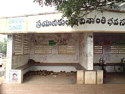
Bus Stop of Velicheru
Velicheru
Dynamic map
India Andhra Pradesh location map (current).svg
Red pog.svg
Velicheru
Coordinates: 16°52′N81°45′E / 16.87°N 81.75°E / 16.87; 81.75
Country Flag of India.svg  India
State Andhra Pradesh
District Dr. B.R. Ambedkar Konaseema
Mandal Atreyapuram
Population
 (2011)
  Total4,627
Time zone UTC+5:30 (IST)
PIN Code
533235

Velicheru is one of the 15 villages of Atreyapuram Mandal, located in Dr. B.R. Ambedkar Konaseema district [1] of the Indian State of Andhra Pradesh. It is located at a distance of 16km from the municipal corporation of Rajahmundry.

Contents

Geography

Velicheru is located at 16.87°N, 81.75°E. [2] It is geographically located in the delta region formed by the bifurcation of the river Godavari. Velicheru shares its boundary with both the distributaries of Godavari i.e., the Vasishta Godavari and the Gautami Godavari.

Various crops like Paddy, Banana and various types of flowers like Lily, Chrysanthemum are cultivated in the village. The soil in the area, being highly fertile, allows cultivation of multiple crops in a year.

Transport

Velicheru has regular government operated buses to the nearby city of Rajahmundry as well as Ravulapalem. From there, buses, trains and flights are available for travelling to various parts of the country.

Apart from buses, passengers can avail services of Auto Rickshaws which are frequently used in this route.

Nearest railway station is Rajahmundry railway station and airport is Rajahmundry airport located at distances of 16km and 33km respectively.

Related Research Articles

<span class="mw-page-title-main">Coastal Andhra</span> Geographic region of Andhra Pradesh, India

Coastal Andhra or Kosta Andhra is a geographic region in the Indian state of Andhra Pradesh. Vijayawada is the largest city in this region. Region share borders with Uttarandhra, Rayalaseema and Telangana. It was part of Madras State before 1953 and Andhra State from 1953 to 1956. According to the 2011 census, it has an area of 91,915 square kilometres (35,489 sq mi) which is 57.99% of the total state area and a population of 34,193,868 which is 69.20% of Andhra Pradesh state population. This area includes the coastal districts of Andhra Pradesh on the Circar Coast between the Eastern Ghats and the Bay of Bengal, from the northern border with Odisha to Rayalaseema in the south.

<span class="mw-page-title-main">Rajahmundry</span> District Headquarter in Andhra Pradesh, India

Rajahmundry, officially known as Rajamahendravaram, is a city in the Indian state of Andhra Pradesh and district headquarters of East Godavari district. It is the seventh most populated city in the state. During British rule, the district of Rajahmundry was created in the Madras Presidency in 1823. It was reorganised in 1859 and bifurcated into the Godavari and Krishna districts. Rajahmundry was the headquarters of Godavari district, which was further bifurcated into East Godavari and West Godavari districts in 1925. It is administered under Rajahmundry revenue division of the East Godavari district. The city is known for its floriculture, history, culture, agriculture, economy, tourism, and its heritage. It is known as the "Cultural Capital of Andhra Pradesh".

<span class="mw-page-title-main">West Godavari district</span> District of Andhra Pradesh in India

The West Godavari district is a coastal district in the Indian state of Andhra Pradesh with an administrative headquarters in Bhimavaram. As of the 2011 Census of India, the district has an area of 2,178 km2 (841 sq mi) and a population of 1,779,935. It is bounded by the Krishna district and Bay of Bengal to the south, East Godavari district to the east, and Eluru district, Kolleru Lake and Upputeru Drain to the northwest.

<span class="mw-page-title-main">Kovvur</span> Town in Andhra Pradesh, India

Kovvur is a town in the East Godavari district of the Indian state of Andhra Pradesh. It is a municipality and the mandal headquarters of Kovvur mandal in Kovvur revenue division.

<span class="mw-page-title-main">Bhimavaram</span> City in Andhra Pradesh, India

Bhimavaram is a city and headquarters of West Godavari district of the Andhra Pradesh state of India. It is the administrative headquarters of Bhimavaram mandal in Bhimavaram revenue division. It is a part of Eluru Urban Development Authority. As of 2011 census, it is the most populous urban area in the district with a population of 163,875. It is one of the major pilgrimage centers in the state, which is home to Somaramam, one of the five great Pancharama Kshetras.

<span class="mw-page-title-main">Palakollu</span> City in Andhra Pradesh, India

Palakollu is a city and the administrative headquarters of Palakollu Mandal in Narasapuram revenue division in West Godavari district of the Indian state of Andhra Pradesh. Palakollu is situated in Coastal Andhra region of the state. It occupies 4.685 square kilometres (1.809 sq mi). As of 2011 census, it had a population of about 61,284 and a Metro population of about 81,199. Palakollu Municipality merged five Grama panchayats of Seven village's on 7 January 2020. The Seven Villages' had a population of 42,932 as of 2011 Census. It around occupies 20.08 square kilometres (7.75 sq mi) and after merged palakollu municipality, It around occupies 24.68 square kilometres (9.53 sq mi) with 35 election wards it is total population of 1,04,216 and making it the third most populous urban area in West Godavari District in Andhra Pradesh. It is a part of Eluru Urban Development Authority.

<span class="mw-page-title-main">Tadepalligudem</span> City in Andhra Pradesh, India

Tadepalligudem is a city in West Godavari district of the Indian state of Andhra Pradesh. It is a Selection Grade municipality and the mandal headquarters of Tadepalligudem mandal and Tadepalligudem Revenue Division. Tadepalligudem is one of the biggest City in West Godavari district

<span class="mw-page-title-main">Konaseema</span> Place

Konaseema is a group of islands between the tributaries of the Godavari River and Bay of Bengal located in Dr. B. R. Ambedkar Konaseema district of Andhra Pradesh in southern India. It is nicknamed "God's own creation" due to similarities with the Kerala backwaters.

<span class="mw-page-title-main">Amalapuram</span> Place in Andhra Pradesh, India

Amalapuram is a town in the Indian state of Andhra Pradesh. It is the district headquarters and the third largest town of Dr. B. R. Ambedkar Konaseema district. It is the mandal and divisional headquarters of Amalapuram mandal and Amalapuram revenue division respectively. The town is situated in the delta of konaseema.

Mandapeta was originally called "Mandavyapuram", which came from Sage Mandukya. Mandapeta is a second-grade municipality established on October 1, 1958 in Dr. B.R. Ambedkar Konaseema district in the Indian state of Andhra Pradesh. It is located at mean elevation of about 15.48 msl at 16.520 N, 81.560 E.

Ramachandrapuram is a town in Dr. B.R. Ambedkar Konaseema district of the Indian state of Andhra Pradesh. The town is a Municipality which serves as the headquarters of Ramachandrapuram mandal and Ramachandrapuram revenue division.

<span class="mw-page-title-main">Mummidivaram</span> Town in Andhra Pradesh, India

Mummidivaram is a town in Dr. B.R. Ambedkar Konaseema district of Andhra Pradesh, India. The Mummidivaram revenue block was formed out of the Amalapuram tehsil in July 1969. It is the second largest town in Konaseema district.

<span class="mw-page-title-main">Ravulapalem</span> Village in Andhra Pradesh, India

Ravulapalem is a village in Ravulapalem Mandal, Dr. B.R. Ambedkar Konaseema district of Andhra Pradesh. Ravulapalem is the entry point for the lushy green Konaseema Delta region, often called the Kerala of Andhra. Ravulapalem is well known for its Banana Market, diverse cuisine, hospitality of its people & numerous trucking services that caters to PAN India.

Kothapeta is a village in Kothapeta mandal of Dr. B. R. Ambedkar Konaseema of the Indian state of Andhra Pradesh.

Malikipuram is a town of Dr. B.R. Ambedkar Konaseema district in Andhra Pradesh, India. It is located in the Amalapuram revenue division.

<span class="mw-page-title-main">Pasarlapudi</span>

Pasarlapudi is the river delta of the Godavari River at the Bay of Bengal in southeastern India. It is located in the Dr. B.R. Ambedkar Konaseema district of Andhra Pradesh state, in the South India Region.

National Highway 216 is a National Highway in the Indian state of Andhra Pradesh. The former highways of NH 214 and 214A were merged and renumbered as NH 216. It starts from NH 16 junction at Kattipudi and passes through Kakinada, Amalapuram, Digamarru (Palakollu), Narasapuram, Machilipatnam, Repalle, Cherukupalle, Bapatla, Chirala before it junctions NH 16 again at Ongole. Visakhapatnam–Kakinada Petro Chemical Corridor, is a proposed project along the highway.

Bhatnavilli is a village in the Amalapuram Mandal of Dr. B.R. Ambedkar Konaseema district in the State of Andhra Pradesh, India. The village is located by the national highway 216 which is now being expanded to a six lane highway. Amalapuram railway station is being proposed to be located here.

<span class="mw-page-title-main">Konaseema district</span> District in Andhra Pradesh, India

Konaseema district, is one of the 26 districts in the Indian state of Andhra Pradesh. It is situated between the tributaries of the Godavari river in the Konaseema region of Coastal Andhra. It was carved out of East Godavari district on 4 April 2022 by the Government of Andhra Pradesh. Amalapuram is the district headquarters and the largest city in this district. The district shares boundaries with West Godavari, East Godavari and Kakinada districts.

<span class="mw-page-title-main">Odalarevu</span> Village in Andhra Pradesh, India

Odalarevu is a village located in the Allavaram mandal, Dr. B. R. Ambedkar Konaseema district of the Indian state of Andhra Pradesh. Situated in the coastal region of the state, the village is bounded by the Godavari River on one side and the Bay of Bengal on the other.

References

  1. "Village & Panchayats | Dr. B. R. Ambedkar Konaseema District | India" . Retrieved 2023-11-28.
  2. "Velicheru · Andhra Pradesh 533235, India". Velicheru · Andhra Pradesh 533235, India. Retrieved 2023-11-28.