
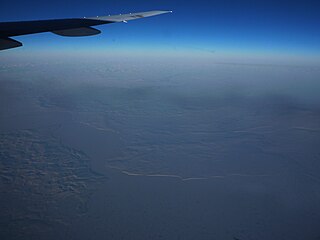
The Anadyr is a river in the far northeast of Siberia which flows into the Gulf of Anadyr of the Bering Sea and drains much of the interior of Chukotka Autonomous Okrug. Its basin corresponds to the Anadyrsky District of Chukotka.

The Velikaya is a river in Novosokolnichesky, Pustoshkinsky, Sebezhsky, Opochetsky, Pushkinogorsky, Ostrovsky, Palkinsky, and Pskovsky Districts of Pskov Oblast, as well as in the city of Pskov in Russia. It is the largest tributary of Lake Peipus and belongs to the drainage basin of the Narva. It is 430 kilometres (270 mi) long, and the area of its basin 25,200 square kilometres (9,700 sq mi). The name of the river literally means "Grand" or "Great" in Russian. The towns of Opochka, Ostrov and Pskov are located on the banks of the Velikaya. The principal tributaries of the Velikaya are the Alolya (right), the Issa (left), the Sorot (right), the Sinyaya (left), the Utroya (left), the Kukhva (left), the Cheryokha (right), and the Pskova (right).
The Kanchalan is a river in Chukotka Autonomous Okrug, Russian Far East. It is 426 kilometres (265 mi) long, and has a drainage basin of 20,600 square kilometres (8,000 sq mi).
The Tumanskaya is a river in Far East Russia. It flows through the Anadyr Lowlands, a region of wetlands and tundra, and into the Bering Sea at the Tymna lagoon. It is 268 kilometres (167 mi) long, and has a drainage basin of 9,270 square kilometres (3,580 sq mi).
The Avtatkuul is a stream in Far East Russia. It is 197 kilometres (122 mi) long, and has a drainage basin of 1,290 square kilometres (500 sq mi). It flows through the Nizhneanadyrskaya lowlands, a region of wetlands, small lakes and tundra into the Bering Sea at the Anadyr Bay.

The Tretya Rechka is a stream in the Beringovsky District of Chukotka Autonomous Okrug, Russia. It is 99 kilometres (62 mi) long. It drains part of the southern Anadyr Lowlands. It flows northeast and then northwest into the Anadyr Estuary. To the east of the Tretya is the Avtatkuul zakaznik protected area. To the south is the Tumanskaya.
The Vtoraya Rechka is a stream in Far East Russia. It is 81 kilometres (50 mi) long. It flows through a region of wetlands and tundra into the Bering Sea at the Anadyr Bay, close to the Tretya Rechka.

The Rauchua is a river in Far East Siberia, Russia. It is 323 kilometres (201 mi) long, and has a drainage basin of 15,400 square kilometres (5,900 sq mi).
The Maly Anyuy is a river in the Kolyma basin in the Russian Far East. Most of the basin of the Maly Anyuy and its tributaries belongs to the Chukotka Autonomous Okrug administrative region of Russia.

The Bolshoy Anyuy is a river in the Kolyma basin in Far East Siberia. Administratively most of the basin of the Bolshoy Anyuy and its tributaries belong to the Chukotka Autonomous Okrug of Russia.
The Belaya in its upper course Yurumkuveyem is a south-flowing tributary of the Anadyr in the Chukotka Autonomous Okrug administrative region of Russia.
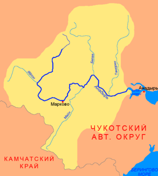
The Mayn is a river in Chukotka Autonomous Okrug in Russia, one of the major tributaries of the Anadyr. The length of the river is 475 kilometres (295 mi). The area of is drainage basin is 32,800 square kilometres (12,700 sq mi).

The Chegitun is a river located in the Chukotka Peninsula in Far East Siberia. It is the easternmost river flowing into the Chukchi Sea from the Siberian side, which makes it the easternmost significant river of the Eurasian continent. It is 137 kilometres (85 mi) long, and has a drainage basin of 4,120 square kilometres (1,590 sq mi).

The Kara is a river draining to the Arctic Kara Sea in Russia. It flows through the Pai-Khoi Range in the Polar Ural region, and forms parts of the borders between the Yamalo-Nenets Autonomous Okrug, the Nenets Autonomous Okrug and the Komi Republic.
The Enmyvaam is a river located in the Chukotka Autonomous Okrug in the Russian Far East, about 150 km (93 mi) southeast of Chaunskaya Bay. It is fed by and is the main and only outflow of Lake Elgygytgyn, draining into the Belaya, which drains into the Anadyr and eventually the Bering Sea.
The Pekulney Range is a range of mountains in far North-eastern Russia. Administratively the range is part of the Chukotka Autonomous Okrug of the Russian Federation. The area of the range is desolate and uninhabited.
The Bolshaya is a river in the western Kamchatka Peninsula, Russia. It is used for spawning by various species of Pacific salmon. The Bolshaya is 275 kilometres (171 mi) long and has a catchment area of 10,800 square kilometres (4,200 sq mi).
The Yablon is a river in Chukotka Autonomous Okrug, Russia. It has a length of 242 kilometres (150 mi) and a drainage basin of 9,280 square kilometres (3,580 sq mi).
The Yeropol is a river in Chukotka Autonomous Okrug, Russia. It has a length of 261 kilometres (162 mi) and a drainage basin of 10,700 square kilometres (4,100 sq mi).

The Kedon is a river in Magadan Oblast, Russia. It has a length of 296 kilometres (184 mi) and a drainage basin of 10,300 square kilometres (4,000 sq mi).

