Pathanamthitta District, is one of the 14 districts in the Indian state of Kerala. The district headquarters is in the town of Pathanamthitta. There are four municipalities in Pathanamthitta: Adoor, Pandalam, Pathanamthitta and Thiruvalla.

Thiruvalla, also spelled Tiruvalla, is a municipality in Pathanamthitta district, Kerala, India. It is also the headquarters of the Thiruvalla taluk. The town is spread over an area of 25.5 km2 (9.8 sq mi) and has a population of 52,883, down from 56,837 in 2001. It lies on the northern banks of the Manimala River, in a land-locked region surrounded by irrigating canals and rivers. It is the largest town in the district, and is one of the financial, educational, cultural, and commercial centres of central Travancore.

Kumbanad is a town located in the Koipuram Town Panchayath Along with Pullad. It is part of Thiruvalla Taluk of Pathanamthitta district in the State of Kerala. It is an important town situated on T.K. Road, equidistant from Eraviperoor and Pullad; which are at a distance of 3 km.

Mallappally is a taluk in Kerala, India. It is one of the five taluks that make up the Pathanamthitta district. It is historically a part of the kingdom of Travancore and Cochin. Mallappally is the original home of many non-resident Indians, and has one of the lowest population growth and highest literacy rates in India. It is under the supervision Thiruvalla Revenue Division & Thiruvalla Constituency.

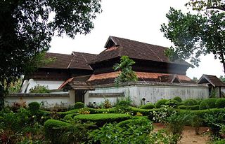
Kayamkulam is a town and municipality in the Onattukara region of Alappuzha district in Kerala. It is the second biggest town in Alappuzha district. It is located on the western coast of India, and was an ancient maritime trading center.Kayamkulam is part of the Karthikappally tehsil. Krishnapuram Palace is located nearby.

Bekal is a small town in the Kasaragod district on the West coast of the state of Kerala, India.

Edathua is a small village in Kuttanad, Alappuzha district, Kerala, India. It is located 12 km from Thiruvalla city center, National Highway 183 and the Thiruvalla railway station.
The Main Central Road popularly known as MC Road is the arterial State Highway starting from Kesavadasapuram in Trivandrum city and ends at Angamaly, a suburb of Kochi city in Ernakulam District, in the state of Kerala, India. It is designated as State Highway 1 by the Kerala Public Works Department. The highway was built by Raja Kesavadas, Dewan of Travancore, in the 1790s. Plan for a new highway called Thiruvananthapuram–Angamaly Greenfield Highway, which runs parallel to the MC Road is proposed and is under early stage of development.

Pathanamthitta, is a municipality situated in the Southern Kerala, India, spread over an area of 23.50 km2. It is the administrative capital of Pathanamthitta district. The town has a population of 37,538. The Hindu pilgrim centre Sabarimala is situated in the Pathanamthitta district; as the main transport hub to Sabarimala, the town is known as the 'Pilgrim Capital of Kerala'. Pathanamthitta District, the thirteenth revenue district of the State of Kerala, was formed with effect from 1 November 1982, with headquarters at Pathanamthitta. Forest covers more than half of the total area of the District. Pathanamthitta District ranks the 7th in area in the State. The district has its borders with Allepey, Kottayam, Kollam and Idukki districts of Kerala and Tamil Nadu. Nearest city Is Thiruvalla, located at a distance of 30 km. Thiruvalla railway station Is 30 km via Thiruvalla-Kumbazha highway. Buses ply every 5 Minutes from Thiruvalla To Pathanamthitta & vice versa.

Arattupuzha is a cultural village in Thrissur district of Kerala in South India, approximately 12 kilometres (7.5 mi) South of the town of Thrissur.

Parumala is a small village and island on the Pampa River in Thiruvalla Taluk, Pathanamthitta district in Kerala, India. It is a part of Thiruvalla sub-district & Thiruvalla constituency.
Chakkulathukavu Temple is a Hindu temple dedicated to the goddess Durga. Situated near Thiruvalla in Neerattupuram, Thalavady Panchayat, Alappuzha District, Kerala, India, it is one of the most renowned temples in the state.
Vazhoor is a town in Kottayam district in the state of Kerala, India.It is a village, panchayat and block with headquarters at Kodungoor on NH183. Basically an agrarian community inhabits this part, whose income depends on rubber cultivation
Eraviperoor is a village in Thiruvalla Taluk,Pathanamthitta district in the state of Kerala. Eraviperoor is the part of Thiruvalla Taluk in east location and is part of the Aranmula legislative assembly constituency.It Comes Under Thiruvalla Sub-District.Located At 8 km Distance From Thiruvalla Sub-District Headquarter And NH 183 In Thiruvalla City India.
Kavumbhagom, also spelled Kavumbhagam, is a ward and a census village in Thiruvalla municipality, in the Pathanamthitta district of Kerala, India. The village has a population of 6644 as of 2011. Kavumbhagom is an important junction serving as a major road route connecting Changanasserry, Thiruvalla, Chathenkary, and Mavelikkara. The Thiruvalla Sree Vallabha temple, after which the town of Thiruvalla has been named, is located in Kavumbhagom.
Thelliyoor is a village Near Thiruvalla in Pathanamthitta district in the state of Kerala, India.

The SH-07 / T.K.Road is the life line of the Central Travancore.
State Highway 6 is a State Highway in Kerala, India that starts in Kayamkulam and ends in Thiruvalla. The highway is 30.8 kilometres (19.1 mi) long.(NH66 to MC road)
Kuttappuzha is a revenue village and postal code in Thiruvalla, Kerala, located approximately 1.3 kilometres north of the town centre. The revenue village was formed by bifurcating the Thiruvalla revenue village in 1985. The name Kuttapuzha is also used to refer to areas under the Thiruvalla R.S. (689101) postal code.

Sultan Bathery temple, originally known as Ganapathi Vattam, is a famous Jain temple located at Sultan Bathery, earlier known as Kidanganad town of Kerala.


