
Belém, often called Belém of Pará, is a Brazilian city, capital and largest city of the state of Pará in the country's north. It is the gateway to the Amazon River with a busy port, airport, and bus/coach station. Belém lies approximately 100 km upriver from the Atlantic Ocean, on the Pará River, which is part of the greater Amazon River system, separated from the larger part of the Amazon delta by Ilha de Marajó. With an estimated population of 1,303,403 people — or 2,491,052, considering its metropolitan area — it is the 12th most populous city in Brazil, as well as the 16th by economic relevance. It is the second largest in the North Region, second only to Manaus, in the state of Amazonas.
The History of Belém refers to the history of this Brazilian municipality in the Northern Region of the country, the capital of the state of Pará, which had its origins in the 17th century in the indigenous region of Mairi, located 160 km from the equator.
The following is a timeline of the history of the city of Belém, in the state of Pará, Brazil.
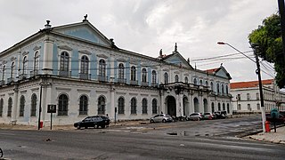
The Palácio Antônio Lemos, also called the Belém Art Museum, is a public building, palace, museum, and the city hall of Belém, built in 1860 by José da Gama Abreu, in the context of the rubber cycle. It is located in the Cidade Velha neighborhood.

The Feira do Açaí is a public trading post, an open-air market for the commercialization of açaí, a small port area, and a set of bars, which is part of the Ver-o-Peso Complex, located on the shores of the Guajará Bay in the district of Cidade Velha, in the city of Belém, Pará, Brazil. The fair is surrounded by the Castelo Fort (1616), the Relógio Square, and the Doca da embarcações.

Feliz Lusitânia, now known as Conjunto Arquitetônico e Paisagístico Feliz Lusitânia or Complexo Turístico Feliz Lusitânia, was a Portuguese colonial settlement created in 1616 by Captain Francisco Caldeira Castelo Branco in the then Conquista do Pará, at the time of the overseas province of Colonial Brazil, originating the Pará municipality of Belém. Feliz Lusitânia is the historical center of this municipality, located in the district of Cidade Velha, a port and tourist area restored in 2002 by the Government of the State of Pará, when the city was going through a process of historical urban decay due to verticalization.

Cidade Velha, initially called Mairi, Cidade or Sé neighborhood, is a historic area of the capital of Pará, Belém, founded in the 1620s. It is the first and oldest neighborhood in the city, originated from the Portuguese colonial settlement Feliz Lusitânia and the construction of the wooden fortress Forte do Presépio, at the mouth of the Piry creek, by Portuguese Captain-Mor Francisco Caldeira Castelo Branco, on January 12, 1616. He had the goal of occupying the Conquista do Pará in the then Captaincy of Maranhão, ensuring the dominance of the region and the drogas do sertão.
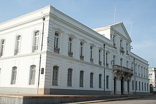
Lauro Sodré Palace, also called Government Palace, and initially called Residence House, is a public building, palace, museum and seat of the state government, built in 1680 and located in the neighborhood of Cidade Velha, in the Brazilian city of Belém, in the state of Pará.
The Dom Frei Caetano Brandão Square, originally called Largo da Sé, is located in the Cidade Velha neighborhood in the Brazilian city of Belém, capital of the state of Pará.

Solar da Beira is a public building designed in the neoclassical architectural style that integrates the Ver-o-Peso Complex. It is located in the Brazilian city of Belém, Pará, in the Cidade Velha neighborhood, on the shores of Guajará Bay. There is no record of its construction, but it is believed to have been built in the 19th century, shortly after the Ver-o-Peso Market, which dates back to 1901. At the beginning of the 20th century, it housed the Revenue Office.

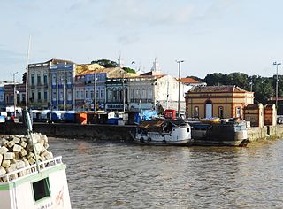
The Ver-o-Peso Complex is an architectural and landscape site located on Boulevard Castilhos França, in the Cidade Velha neighborhood, Belém, capital of Pará. It began to be formed in 1625 with the construction of the Casa de Haver-o-Peso commercial tax office, and in 1977 it was listed as a heritage site by the National Institute of Historic and Artistic Heritage (IPHAN). The complex covers an area of 35,000 m2 and includes several historic buildings in line with the French art nouveau trend of the Belle Époque, such as:

Guajará Bay is formed by the confluence of the mouths of the Guamá and Acará rivers, which border the municipalities of Barcarena and Belém, the capital of Pará. Its waters flow into Marajó Bay and end in the Atlantic Ocean.

The Francisco Bolonha Municipal Meat Market, Bolonha Market or simply Meat Market, is a structure built in 1867 that belongs to the Ver-o-Peso Complex. It is located in the Brazilian city of Belém, capital of Pará, on Boulevard Castilhos França, in the neighborhood of Campina.

The Siqueira Campos Square or Clock Square is a public space located at the Ver-o-Peso Dock, in the Cidade Velha neighborhood, in the Brazilian city of Belém, capital of Pará. The site, which is known for housing a huge English clock, comprises a total area of 2,727.45m², 1,246.78m² of paved area and 1,480.67m² of green area.

Ver-o-Peso Dock is an open-air municipal public fish market and a small port area that belongs to the Ver-o-Peso Complex, located on the shores of Guajará Bay in the Cidade Velha neighborhood, in the city of Belém, the capital of Pará, Brazil. The dock is surrounded by the Clock Square, the Açaí Fair and the Ver-o-Peso Market.

Solar Barão de Guajará, also known as Casa à Praça Pedro II, is a manor house located in Belém, the capital of the state of Pará, Brazil, more specifically in the Dona Tomázia Perdigão Street. It was built in the 19th century and has three floors, the last of which is smaller. The inner courtyard shows elements of the Moorish influence on Iberian architecture.
Culture and tourism in Belém, the capital of Pará, is influenced by indigenous people and foreign immigrants, who manifest themselves through religious manifestations, gastronomy, folklore, dances, music, theaters, museums, among others. Belém stands out as a great tourist destination in Brazil, creating an excellent opportunity for travel investment.

Pinho Mansion is a historic building located at 586 Doutor Assis Street in the Cidade Velha district, in Belém, the capital of the state of Pará. In 1986, it was listed as a national heritage site by the National Institute of Historic and Artistic Heritage (IPHAN) for its importance in the city.

Boulevard Castilhos França, originally called Rua Nova do Imperador and Boulevard daRepública, is a street located in the Campina neighborhood, on the shores of Guajará Bay, in the Brazilian city of Belém, capital of the state of Pará. Created in 1848, it is one of Belém's first wide thoroughfares. In 1930, it was renamed Boulevard Castilhos França in honor of Navy Commander Eurico de Castilhos França.

The São Brás Market is a historic building located in the Brazilian city of Belém, in the state of Pará. It was built during the Amazon rubber cycle. Construction began on May 1, 1910, and was completed on May 21, 1911.


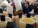 Manioc flour sales stand.
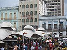 Market stalls at the Ver-o-Peso Market
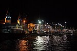


