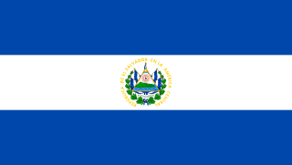
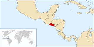
El Salvador, officially the Republic of El Salvador, is a country in Central America. It is bordered on the northeast by Honduras, on the northwest by Guatemala, and on the south by the Pacific Ocean. El Salvador's capital and largest city is San Salvador. As of 2018, the country had a population of approximately 6.42 million.

Alta Verapaz is a department in the north central part of Guatemala. The capital and chief city of the department is Cobán. Verapaz is bordered to the north by El Petén, to the east by Izabal, to the south by Zacapa, El Progreso, and Baja Verapaz, and to the west by El Quiché.

The Farabundo Martí National Liberation Front is one of the two major political parties in El Salvador.

Rabinal is a small town, with a population of 15,157, located in the Guatemalan department of Baja Verapaz, at 15°5′4.70″N90°29′20.50″W. It serves as the administrative seat for the surrounding municipality of the same name. The municipality covers an area of 336 km² with a population of 40,797. The local people are predominantly Achi Maya Native Americans who speak the Achi Maya language.

San Miguel is a city in eastern El Salvador. It is the country's third most populous city. It is located 138 km east of the capital, San Salvador. It is also the capital of the department of San Miguel and a municipality. The population of the city in 2017 was 518,410.

Cucuyagua is a municipality in the Honduran department of Copán.
Langue is a municipality in the Valle Department, Honduras.
Estanzuelas is a municipality in the Usulután department of El Salvador.

Santiago Texacuangos is a municipality in the San Salvador department of El Salvador.

Conchagua is a municipality in the La Unión department of El Salvador. It contains the Conchagua volcano.

Las Vueltas is a municipality in the Chalatenango Department in the north of El Salvador. The municipality is bordered to the north by Ojos de Agua, to the east by Las Flores, to the south by Chalatenango, and to the northeast by Concepción Quezaltepeque. The territory covers 36.83 km² and the population was, as of 2005, of 2,101 inhabitants. For its administration, the municipality is divided into six cantones and 35 caseríos.
San Cayetano Istepeque, is a municipality in the San Vicente department of El Salvador. Its altitude is approximately 510 m.
Tepetitán is a municipality in the San Vicente department of El Salvador.

Sensuntepeque is a town and municipality in the Cabañas department of El Salvador. It is the seat of the department and principal town in the area. Sensuntepeque is located about 83 kilometres (52 mi) northeast of the capital, San Salvador, at an altitude of 820 metres (2,690 ft).

Estadio Juan Francisco Barraza is a multi-purpose stadium in San Miguel, El Salvador. It is currently used mostly for football matches and is the home stadium of C.D. Águila and C.D. Dragón. It is named after the 1950s star Juan Francisco "Cariota" Barraza in 1982. The stadium holds 10,000 people.
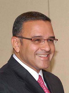
Carlos Mauricio Funes Cartagena is a Salvadoran politician who was President of El Salvador from 1 June 2009 to 1 June 2014. He won the 2009 presidential election as the candidate of the left-wing Farabundo Martí National Liberation Front (FMLN) political party and took office on 1 June 2009.
Chahal is a municipality in the Guatemalan department of Alta Verapaz. The name originates from the Mayans.
The 2009 El Salvador floods and mudslides occurred November 6–9 affecting areas including San Salvador, La Paz, Cuscatlan, Usulutan and San Vicente. The disaster was triggered by a low-pressure system from the Pacific, and flooding from heavy rains caused mud and rock slides that killed approximately 130 people and left 60 missing.

The Cathedral Basilica of Queen of Peace, also called San Miguel Cathedral, is a Catholic church located in the city of San Miguel, El Salvador.

The USS YP-72 (ex-Cavalcade) was a converted fishing vessel which served as an auxiliary patrol boat in the U.S. Navy during World War II.


