Escuintla is an industrial city in Guatemala, its land extension is 4384 km², and it is nationally known for its sugar agribusiness. Its capital is a minicipality with the same name. Citizens celebrate from December 6 to 9 with a small fair in honor to The Immaculate Conception.

Iztacalco is a borough in Mexico City. It is located in the central-eastern area and it is the smallest of the city's boroughs. The area's history began in 1309 when the island of Iztacalco, in what was Lake Texcoco, was settled in 1309 by the Mexica who would later found Tenochtitlan, according to the Codex Xolotl. The island community would remain small and isolated through the colonial period, but drainage projects in the Valley of Mexico dried up the lake around it. The area was transformed into a maze of small communities, artificial islands called chinampas and solid farmland divided by canals up until the first half of the 20th century. Politically, the area has been reorganized several times, being first incorporated in 1862 and the modern borough coming into existence in 1929. Today, all of the canals and farmland are dried out and urbanized as the most densely populated borough and the second most industrialized.

Tláhuac is a borough in the Mexico City, located in the southeastern edge of the entity. Though Tláhuac still contains rural communities within its borders, mostly in the southern and eastern portions, the borough has undergone a massive shift from urbanization, especially in its northwest. Tláhuac has experienced the fastest rate of population growth in Mexico City since the 1960s.
Toa Baja is a town and municipality of Puerto Rico located in the northern coast, north of Toa Alta and Bayamón; east of Dorado; and west of Cataño. Toa Baja is spread over five barrios, including Toa Baja Pueblo. Toa Baja is part of the San Juan-Caguas-Guaynabo Metropolitan Statistical Area. Toa Baja is located fifteen minutes by car from San Juan and two hours from Ponce.

Cabañas is a department of El Salvador in the north central part of the country. Its capital is Sensuntepeque and it is one of coolest parts of El Salvador. Classified as a department in February 1873, it covers an area of 1,103.5 km2 (426.1 sq mi) and has over 164,900 inhabitants. The other major city of the department is Ilobasco. Agricultural produce includes coffee, sugar cane and sesame seeds, as well as dairy products. Gold, silver and copper are the principal minerals mined in the department. Its main industrial activity is oriented to manufacture of potteries, cheese, lime and also distilleries.

La Libertad is one of the departments of El Salvador and is located in the southwest of the country. The capital is Santa Tecla. It has area 1,653 km² and a population of more than 747,600 people.

San Salvador is a department of El Salvador in the west central part of the country. The capital is San Salvador, which is also the national capital. The department has North of the Rio Lempa Valley, the "Valle de las Hamacas" and a section of Lake Ilopango. Some of the department's cities that are densely populated are: San Salvador, Ciudad Delgado, Mejicanos, Soyapango, Panchimalco and Apopa. The department covers an area of 886.2 square kilometres (342.2 sq mi) and the last census count in 2017 reported 2,404,097 people. It was classified as a department on June 12, 1824. During the time of the colony, the department was the San Salvador Party, from where territory was taken to make the departments of Chalatenago, La Libertad, Cuscatlán and La Paz. This department produces beans, coffee, sugar cane, etc. for agriculture, on the other hand San Salvador Department holds many headquarters for banking companies in El Salvador and Central America, and for many communication services, also the headquarters of the electric companies are located in the San Salvador Department, last years these companies took a step and started exporting electricity to all Central America. The current mayor of the department is Ernesto Muyshondt (2015-2019)

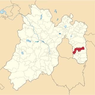
San Vicente is a department of El Salvador in the center of the country. The capital is San Vicente. On October 4, 1834, San Vicente City of Austria and Lorenzana was made the capital of State of El Salvador during the Federal Republic of Central America. In 1840, it was no longer the capital of the State of El Salvador, but it continues to be the capital of the department. The department was created on June 12, 1824. The San Vicente department is 1,184 km2 (457 sq mi) and has a population in excess of 174,500. The forest Bosque La Joya is found in San Vincente.

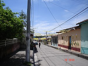
Arcatao is a municipality and small town in the Department of Chalatenango, El Salvador.
Santa Clara is a municipality in the San Vicente Department of El Salvador. It is located approximately 50 kilometers (31 mi) east of San Salvador and approximately 8 kilometers (5.0 mi) from San Vicente. The municipality has approximately 9,750 residents.

Chalchuapa is a town and a municipality located in the Santa Ana department of El Salvador. The city of Chalchuapa is in a wide valley at 650 meters above sea level, and watered by the Pampe River.

Chinandega is a city and the departmental seat of Chinandega department in Nicaragua. It is also the administrative centre of the surrounding municipality of the same name. It is Nicaragua's 2nd most important city (economy) and 6th largest city, with a population of 114,417, and a total of 137,170 in the municipality. It is located about 134 kilometres (83 mi) northwest of Managua and about 72 kilometres (45 mi) southwest of El Guasaule, on the border with Honduras. Chinandega is situated about 20 kilometres (12 mi) from the Pacific Ocean.
Tejutla is a municipality in the western highlands of Guatemala, in the department of San Marcos. Tejutla was officially founded on 25 July 1672, although it was already an important town within the Mam kingdom in 1524, at the time of the Spanish conquest of Guatemala. It is situated high in the mountains, the so-called "cold zone", at about 2500 m altitude.
Jiquipilco Municipality is one of the municipalities of the State of Mexico in Mexico. It is north of the Toluca Valley, part of the region consisting of the southern and western slopes of Cerro La Catedral, which has a concentration of speakers of the Otomi language. It is about 40 km from Toluca, the state capital. The name is a corruption of Nahuatl “Xiquipilli”, meaning “the place of saddlebags”. Jiquipilco is situated on the transversal volcanic axis that crosses Mexico in an area surrounded by lakes and volcanoes. This portion is called "Anahuac”.

Nueva Esparta is a municipality in the northeasternmost zone of El Salvador, inside La Unión Department. The municipality is politically divided into the central Pueblo Nueva Esparta, six outlying canton communities and 31 caserios.

Ameca is a city and municipality, in Jalisco in central-western Mexico. The municipality covers an area of 685.73 km². The city is bisected by the Ameca River which drains to the Pacific Ocean near Puerto Vallarta. It is also approximately 83 km from the state capital and one of Mexico's largest commercial centers, Guadalajara.

Cuquío is a town and municipality, in Jalisco in central-western Mexico. The municipality covers an area of 252 square miles (653 km²). It limits to the North with the municipality of Yahualica and the State of Zacatecas; to the South, Zapotlanejo and Acatic; to the East, Yahualica and Tepatitlán; and to the West, Ixtlahuacán del Río. Its name derives from the word Cuixui, which in the Aztec language Náhuatl means kite, and is interpreted as "place of kites," or in Tarascan language, "place of frogs or toads." The foundation of the town is awarded to the Purépechas (Tarascans) who repeatedly ventured through these valleys after the Saltpeter War (1480-1510). As a third version about the origins of the municipality name, it is well known that the tribe of coquias settled in La Cofradía, two kilometers from the current town, whose name is conjectured the denomination comes from. Cuquío also depended on the Tonalteca kingdom.
Asunción Cuyotepeji is a town and municipality in Oaxaca in south-western Mexico. The municipality covers an area of 547.33 km². It is part of the Huajuapan District in the north of the Mixteca Region. As of 2005, the municipality had a total population of 14,438.Its specific location is in the northwest part of Oaxaca and forms part of a region denominated "La Mixteca" which is a region of Oaxaca in which Nahua civilizations used to be settled. It is 1760 meters above the sea level. Its territory is delimited by other small municipalities. At the north it is limited by Santiago Miltepec and San Juan Bautista Suchitepec municipalities; in south by Santa Maria Camotlan; at the east by Santa Catarina Zapoquila and Santiago Thuitlan Plumas; finally at the west it is delimited by Ciudad de Huajuapan de leon and Santiago Miltepec.
Asunción Ocotlán is a town and municipality in Oaxaca in south-western Mexico. The municipality covers an area of 12.76 km². It is part of the Ocotlán District in the south of the Valles Centrales Region. Its name "Asunción" alludes the assumption of Mary and Ocotlán means between ocotes -Oco (ocote) and tlan (between) in Nahuatl. It borders at north and west with Ocotlán de Morelos, south with San Pedro Apóstol and east with San Pedro Mártir. Almost all the lands are plains and its water sources come from the Mijangos and Atoyac rivers. Its economy is based in agriculture in spite of its semi-desert climate. The largest part of population isCatholic. Its main celebration is The Assumption of Virgin Mary on August 15, moreover they celebrate with a fair, dances and calendas (celebrations of the patron saints of the oaxacans churches. As of 2005, the municipality had a total population of 3257.
Santa Catarina Ayotzingo is a town in the state of Mexico, that belongs to the municipality of Chalco and forms part of the Metropolitan Zone of the Valley of Mexico.