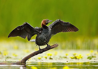
The pygmy cormorant is a member of the Phalacrocoracidae (cormorant) family of seabirds. It breeds in south-eastern Europe and south-western Asia. It is partially migratory, with northern populations wintering further south, mostly within its breeding range. It is a rare migrant to western Europe.

The Pantanal is a natural region encompassing the world's largest tropical wetland area, and the world's largest flooded grasslands. It is located mostly within the Brazilian state of Mato Grosso do Sul, but it extends into Mato Grosso and portions of Bolivia and Paraguay. It sprawls over an area estimated at between 140,000 and 195,000 km2. Various subregional ecosystems exist, each with distinct hydrological, geological, and ecological characteristics; up to 12 of them have been defined.

Ashtamudi Lake, in the Kollam District of the Indian state of Kerala is a unique wetland ecosystem and a large palm-shaped water body. It is second only in size to the Vembanad estuary ecosystem of the state. Ashtamudi means 'eight hills or peaks' in the local Malayalam language. The name is indicative of the lake's topography with its multiple branches. The lake is also called the gateway to the backwaters of Kerala and is well known for its houseboat and backwater resorts. Ashtamudi Wetland was included in the list of wetlands of international importance, as defined by the Ramsar Convention for the conservation and sustainable utilization of wetlands. Ashtamudi Estuary is the deepest among all the estuaries in Kerala, with a maximum depth of 6.4 meters at the confluence zone.

The Berg River is a river located just north of Cape Town in the Western Cape Province of South Africa. It is approximately 294 km (183 mi) long with a catchment area of 7,715 km2 (2979 mi2) and empties into the Atlantic Ocean. About 65% of the Berg River area is under agriculture. The major towns in the Berg River area are Velddrif and Laaiplek near the coast, and Piketberg, Hopefield, Moorreesburg and Darling further inland.
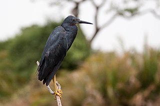
The slaty egret is a small, dark egret found in southern Africa. It is one of the species to which the Agreement on the Conservation of African-Eurasian Migratory Waterbirds (AEWA) applies. It is classified as Vulnerable, the biggest threat being habitat loss.

The Rokel River is the largest river in the Republic of Sierra Leone in West Africa. The river basin measures 10,622 km2 (4,101 sq mi) in size, with the drainage divided by the Gbengbe and Kabala hills and the Sula Mountains. The estuary which extends over an area of 2,950 km2 (1,140 sq mi) became a Ramsar wetland site of importance in 1999.

The Laguna de Santa Rosa is a 22-mile-long (35 km) wetland complex that drains a 254-square-mile (660 km2) watershed encompassing most of the Santa Rosa Plain in Sonoma County, California, United States.

Sasthamcotta Lake or Sasthamkotta Lake, also categorized as a wetland, is the largest fresh water lake in Kerala, a state of India on the south of the West Coast. The lake is named after the ancient Sastha temple located on its bank. It meets the drinking water needs of half million people of the Quilon district and also provides fishing resources. The purity of the lake water for drinking use is attributed to the presence of large population of larva called cavaborus that consumes bacteria in the lake water. The lake is a designated wetland of international importance under the Ramsar Convention since November 2002.

Gavkhouni also written as Gawkhuni or Batlaq-e-Gavkhuni, located in the Iranian Plateau in central Iran, east of the city of Isfahan, is the terminal basin of the Zayandeh River. Gavkhouni is a salt marsh with a salinity of 31.5% and an average depth of about 1 m. The salt marsh can dry up in summer. The Zayandeh River originates in the Zagros mountains, and travels around 300 km, before terminating in Gavkhouni.

Lake Skadar – also called Lake Scutari, Lake Shkodër and Lake Shkodra – lies on the border of Albania and Montenegro, and is the largest lake in Southern Europe. It is named after the Albanian city of Shkodër which lies at its southeastern coast. It is a karst lake.
The Vasse-Wonnerup Estuary is an estuary in the South West region of Western Australia close to the town of Busselton. The estuary is listed with DIWA. It was also recognised as a wetland of international importance under the Ramsar Convention on 7 June 1990 when an area of 1,115 ha was designated Ramsar Site 484 as an important dry-season habitat for waterbirds. It is also the main part of the 2,038 ha (5,040-acre) Busselton Wetlands Important Bird Area.

The Kanwar Taal or Kabar Taal Lake or Kabartal Wetland located in Begusarai district of Bihar, India, is Asia's largest freshwater oxbow lake. It is approximately six times the size of the Bharatpur Sanctuary. In November 2020, the Ministry of Environment, Forest and Climate Change (MoEFCC) declared it the first Ramsar site in Bihar. There are a total of 85 Ramsar Sites in India till 2024.
Kanwar jheel, as it is locally called, is located 22 km north-west of Begusarai Town in Manjhaul. It is a residual oxbow lake, formed due to meandering of Burhi Gandak river, a tributary of Ganga, in the geological past. It covers 2,620 hectares of the Indo-Gangetic plains in the northern Bihar State. The Site is one of 18 wetlands within an extensive floodplain complex; it floods during the monsoon season to a depth of 1.5 metres. This absorption of floodwaters is a vital service in Bihar State where 70% of the land is vulnerable to inundation. During the dry season, areas of marshland dry out and are used for agriculture. Significant biodiversity is present, with 165 plant species and 394 animal species recorded, including 221 bird species. The Wetland is an important stopover along the Central Asian Flyway, with 58 migratory waterbirds using it to rest and refuel. It is also a valuable site for fish biodiversity with over 50 species documented. Five critically endangered species inhabit the site, including three vultures – the red-headed vulture, white-rumped vulture and Indian vulture – and two waterbirds, the sociable lapwing and Baer’s pochard. Major threats to the Site include water management activities such as drainage, water abstraction, damming and canalization.

The Edithvale–Seaford Wetlands is a collection of principally freshwater swamps and marshlands totalling 261 hectares in southeastern Melbourne, Australia, about 30 km (19 mi) southeast of Melbourne CBD. It is the largest natural wetland of its type in the Port Phillip and Western Port basins, and is all that remains of the historic Carrum Carrum Swamp, which once covered more than 4,000 hectares from present-day Mordialloc in the north to Frankston in the south.

Redelinghuys is a village in the Bergrivier Local Municipality in the Western Cape province of South Africa, located about 160 kilometres (100 mi) north of Cape Town on the Verlorevlei River. The 2001 Census recorded the population as 581 people in 167 households. The village is situated on the R366 regional route between Piketberg and Elands Bay. It is served by a police station, a public library, a satellite health clinic, and two primary schools.

Tortuguero National Park is a national park in the Limón Province of Costa Rica. It is situated within the Tortuguero Conservation Area of the northeastern part of the country. Despite its remote location, reachable only by airplane or boat, it is the third-most visited park in Costa Rica. The park has a large variety of biological diversity due to the existence within the reserve of eleven different habitats, including rainforest, mangrove forests, swamps, beaches, and lagoons. Located in a tropical climate, it is very humid, and receives up to 250 inches (6,400 mm) of rain a year.

The Nyl River is a watercourse in Limpopo Province, South Africa. It flows at the head of the Mogalakwena River, being its southernmost tributary or uppermost section. It is located near Mookgophong (Naboomspruit) in the northern part of the Springbok Flats, a particular geological formation.
The Kızılırmak Delta is the delta of the Kızılırmak River where it flows into the Black Sea, 40 km east of the city of Samsun. The delta is the third largest in Turkey and has the biggest wetland in Turkey's Black Sea Region. The wetland is a key biodiversity area and one of several internationally important Ramsar sites in Turkey because of its rich bird and plant life. There is a bird reserve which is important for migration.

The redfin pickerel is a subspecies of freshwater fish belonging to the pike family (Esocidae) of the order Esociformes. Not to be confused with its close relatives, the grass pickerel and the chain pickerel, this fish is unique in the fact that it has brightly colored red fins. Like all pikes, the redfin pickerel is an ambush predator, lying amongst thick vegetation in wait for smaller, more agile prey to enter within its range of attack.

The Buna River-Velipojë Protected Landscape is a protected landscape area in northwestern Albania, encompassing the estuary of Drin, the lagoon of Viluni, the river of Buna with its estuary, and the gulf of Drin that runs across the city of Velipojë alongside the Adriatic Sea.
The Bot River Estuary, also known as the Bot River Lagoon, is part of the Bot-Kleinmond Estuarine System in the Overberg region on the Western Cape of South Africa. It became a Ramsar site wetland in 2017. It is within the Kogelberg Biosphere Reserve.

