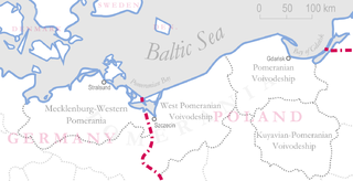
Pomerania is a historical region on the southern shore of the Baltic Sea in Central Europe, split between Poland and Germany. The western part of Pomerania belongs to the German states of Mecklenburg-Western Pomerania and Brandenburg, while the eastern part belongs to the West Pomeranian, Pomeranian and Kuyavian-Pomeranian voivodeships of Poland. Its historical border in the west is the Mecklenburg-Western Pomeranian border Urstromtal which now constitutes the border between the Mecklenburgian and Pomeranian part of Mecklenburg-Western Pomerania, while it is bounded by the Vistula River in the east. The easternmost part of Pomerania is alternatively known as Pomerelia, consisting of four sub-regions: Kashubia inhabited by ethnic Kashubians, Kociewie, Tuchola Forest and Chełmno Land.
Uckermark is a Kreis (district) in the northeastern part of Brandenburg, Germany. Neighbouring districts are Barnim and Oberhavel, the districts Mecklenburgische Seenplatte and Vorpommern-Greifswald in Mecklenburg-Vorpommern, and to the east Poland. It is one of the largest districts of Germany areawise. The district is named after the historical region of Uckermark.

Gryfino is a town in Pomerania, northwestern Poland, with 21,393 inhabitants (2017). It is also the capital of Gryfino County in West Pomeranian Voivodeship, previously in Szczecin Voivodeship (1975–1998).

Nowa Sól is a city on the Oder River in Lubusz Voivodeship, western Poland. It is the capital of Nowa Sól County and had a population of 38,763 (2019).
In the Battle of Cedynia or Zehden, an army of Mieszko I of Poland defeated forces of Hodo or Odo I of Lusatia on 24 June 972, near the Oder river. Whether or not the battle actually took place near the modern-day town of Cedynia is disputed in modern scholarship.

Schwedt is a town in Brandenburg, in northeastern Germany. With the official status of a Große kreisangehörige Stadt, it is the largest town of the Uckermark district, located near the river Oder, which forms the border with Poland.
Kijewo is a municipal neighbourhood of the city of Szczecin, Poland, situated on the right bank of the Oder River, east of the Szczecin Old Town and south-east of Szczecin-Dąbie. As of December 2019, it had a population of 3,515.

Gartz is a town in the Uckermark district in Brandenburg, Germany. It is located on the West bank of the Oder River, on the border with Poland, about 20 km south of Szczecin, Poland. It is located within the historic region of Western Pomerania.

Choszczno(listen) is a town in West Pomeranian Voivodeship, Poland. As of December 2021, the town has a population of 14,831. The town is in a marshy district between the river Stobnica and Klukom lake, 32 kilometres (20 mi) southeast of Stargard and on the main railway line between Szczecin and Poznań. Besides the Gothic church, there are a number of historical buildings from the 19th century industrial period namely, a gasification plant and a water pressure tower which dominates the town's skyline.

The autostrada A6 in Poland is a short motorway that starts at the Polish/German border at Kołbaskowo/Pomellen connecting to the German A11 autobahn. It forms a southern bypass of the Szczecin metropolitan area and terminates at Rzęśnica interchange to the east of the city, from where it continues in an expressway standard as S3 towards Świnoujście and S6 towards Gdańsk. Its length is 29.2 km (18.1 mi). The motorway is part of the European route E28.

Chojnapronounced [ˈxɔi̯na] is a small town in northwestern Poland in the West Pomeranian Voivodeship. It lies approximately 60 kilometres south of Szczecin. As of December 2021, the town has a population of 7,330.

Moryń is a town in Gryfino County, West Pomeranian Voivodeship, in northwestern Poland.
The defense of the Schwedt bridgehead was a German 3rd Panzer Army operation on the Eastern Front during the final months of World War II. German forces, commanded by Otto Skorzeny, were ordered to prepare to conduct a counter-offensive. However they were forced to hold a bridgehead against expected numerically superior forces of the Soviet 2nd Belorussian Front for 31 days. Their position was largely ignored during the Red Army's Cottbus-Potsdam Offensive Operation which breached German defenses at Gartz to the north of Schwedt. This was unexpected because it required the Red Army to cross the Randowbruch Swamp that lay between the Oder and Randow rivers.
Amt Gartz (Oder) is an Amt in the district of Uckermark, in Brandenburg, Germany. Its seat is in Gartz.

Brandenburg-Schwedt was a secundogeniture of the Hohenzollern margraves of Brandenburg, established by Prince Philip William who took his residence at Schwedt Castle in 1689. By appanage, they administered the manors of Schwedt and Vierraden on the Oder river as well as Wildenbruch in Pomerania. Though prosperous, the cadet branch never obtained Imperial immediacy.

Swobnica is a village in the administrative district of Gmina Banie, within Gryfino County, West Pomeranian Voivodeship, in north-western Poland.

The Oder is a river in Central Europe. It is Poland's second-longest river in total length and third-longest within its borders after the Vistula and Warta. The Oder rises in the Czech Republic and flows 742 kilometres (461 mi) through western Poland, later forming 187 kilometres (116 mi) of the border between Poland and Germany as part of the Oder–Neisse line. The river ultimately flows into the Szczecin Lagoon north of Szczecin and then into three branches that empty into the Bay of Pomerania of the Baltic Sea.
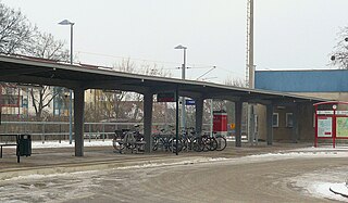
Schwedt (Oder) station is, along with the halt of Schwedt (Oder) Mitte, a station in the town of Schwedt in the Uckermark district of the German state of Brandenburg. It is heritage listed along with the goods sheds, the locomotive shed, the water tower and the water crane.

Historical Western Pomerania, also called Cispomerania,Fore Pomerania, Front Pomerania or Hither Pomerania, is the western extremity of the historic region of Pomerania forming the southern coast of the Baltic Sea, Western Pomerania's boundaries have changed through the centuries as it belonged to various countries such as Poland, the Duchy of Pomerania, Sweden, Denmark, as well as Prussia which incorporated it as the Province of Pomerania.
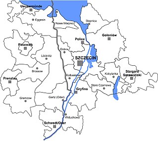
Szczecin agglomeration or Stettin agglomeration is the urban agglomeration of the city of Szczecin and surrounding towns in the Polish-German border area.
