
Kentucky, officially the Commonwealth of Kentucky, is a state in the Southeastern region of the United States and one of the states of the Upper South. Kentucky borders Illinois, Indiana, and Ohio to the north, West Virginia to the northeast, Virginia to the east, Tennessee to the south, and Missouri to the west. Its northern border is defined by the Ohio River. Its capital is Frankfort and its largest city is Louisville. Its population was approximately 4.5 million in 2020.

Frankfort is the capital city of the U.S. state of Kentucky and the seat of Franklin County. It is a home rule-class city. The population was 28,602 at the 2020 United States census. Located along the Kentucky River, Frankfort is the principal city of the Frankfort, Kentucky Micropolitan Statistical Area, which includes all of Franklin and Anderson counties. It is the fourth smallest state capital city in the United States by population.

Breathitt County is a county in the eastern Appalachian portion of the U.S. state of Kentucky. As of the 2020 census, the population was 13,718. Its county seat is Jackson. The county was formed in 1839 and was named for John Breathitt, who was Governor of Kentucky from 1832 to 1834. Breathitt County was a prohibition or dry county, until a public vote in July 2016 that allowed alcohol sales.

South Park View is a home rule-class city in Jefferson County, Kentucky, United States. The population was 0 at the 2020 census. The community was named for its location near South Park Hill, elevation 902 feet (275 m), the highest point in Jefferson County. It is the smallest incorporated city in the commonwealth of Kentucky and one of nine incorporated places in the U.S. that have no recorded population.

Independence is a home rule-class city in Kenton County, Kentucky, in the United States. It is one of its county's two seats of government. The population was 24,757 at the time of the 2010 U.S. census, up from 14,982 at the 2000 census. It is the third largest city in Northern Kentucky after Covington and Florence.

Northern Kentucky is the third-largest metropolitan area in the United States Commonwealth of Kentucky after Louisville and Lexington, and its cities and towns serve as the de facto "south side" communities of Cincinnati, Ohio. The three main counties of this metro area are Boone, Kenton, and Campbell along the Ohio River, with other counties also included. The label "Northern Kentucky" is used to demonstrate the common identity shared across county and city lines by the residents of these northern counties. Arguably, the label seeks to reverse the divisions that occurred to Campbell County, which, in 1794, included the land of Boone, Kenton, Pendleton Counties, and most of Bracken and Grant Counties. The urban and suburban areas of the northern counties are densely populated. Indeed, of Greater Cincinnati's over two million residents, 450,994 of them live in Northern Kentucky (2019), with the three most northern counties contributing 394,163 residents themselves. The largest cities in each of the three most northern counties are Covington, Florence, and Fort Thomas.

George Mortimer Bibb was an American lawyer and politician and the seventeenth United States Secretary of the Treasury. He was chief justice of the Kentucky Court of Appeals and twice represented Kentucky as a senator in Congress, serving from 1811 to 1814 and from 1829 to 1835.
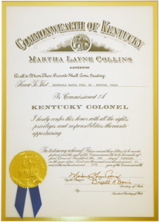
Kentucky Colonel is the highest title of honor bestowed by the Commonwealth of Kentucky, and is the best-known of a number of honorary colonelcies conferred by United States governors. A Kentucky Colonel Commission is awarded in the name of the Commonwealth by the Governor of Kentucky to individuals with "Honorable" titular style recognition preceding the names of civilians aged 18 or over, for noteworthy accomplishments, contributions to civil society, remarkable deeds, or outstanding service to the community, state, or a nation. The Governor bestows the honorable title with a colonelcy commission, by issuance of letters patent.

The Louisville metropolitan area is the 43rd largest metropolitan statistical area (MSA) in the United States. It had a population of 1,395,855 in 2020 according to the latest official census, and its principal city is Louisville, Kentucky.

Breaks Interstate Park is a bi-state state park located partly in southeastern Kentucky and mostly in southwestern Virginia, in the Jefferson National Forest, at the northeastern terminus of Pine Mountain. Rather than their respective state park systems, it is instead administered by an interstate compact between the states of Virginia and Kentucky. It is one of several interstate parks in the United States, but only one of two operated jointly under a compact rather than as two separate state park units. The Virginia Department of Conservation and Recreation and the Kentucky Department of Parks are still major partner organizations.

Pine Mountain State Resort Park is a Kentucky state park located in Bell County, southeastern Kentucky, United States. Located on part of the Pine Mountain ridge in the Appalachians, the park opened in 1924 as Kentucky's first state park.

The Ohio River Islands National Wildlife Refuge (ORINWR) is a National Wildlife Refuge (NWR) in non-contiguous sites consisting of islands along 362 miles (583 km) of the Ohio River, primarily in the U.S. state of West Virginia.

The Valley View Ferry provides passage over the Kentucky River in rural central Kentucky. Located on Kentucky Route 169, this ferry service connects auto traffic between the county seats of Richmond in Madison County, Nicholasville in Jessamine County and Lexington Kentucky. The route leads you directly to downtown Richmond, Lexington and Nicholasville.
Samuel Brown Taylor was an American educator, Negro league baseball player, and college football coach. He served as the head football coach at Virginia State College for Negroes—now known as Virginia State University—in 1925, Clark College—now known as Clark Atlanta University—from 1925 to 1929, Prairie View State Normal & Industrial College—now known as Prairie View A&M University—from 1931 to 1943, Virginia Union University from 1945 to 1948, Bluefield State College—now known as Bluefield State University—from 1948 to 1958, and Kentucky State College—now known as Kentucky State University—from 1959 to 1962.

The Confederate Monument in Russellville, in the middle of the Russellville Historic District of Russellville, Kentucky, is a monument to the Confederate States of America that is on the National Register of Historic Places since July 17, 1997.
The Louisville Leader was a weekly newspaper published in Louisville, Kentucky, from 1917 to 1950.

The Illinois–Indiana–Kentucky tri-state area is a tri-state area where the U.S. states of Illinois, Indiana, and Kentucky intersect. The area is defined mainly by the television viewing area and consists of ten Illinois counties, eleven Indiana counties, and nine Kentucky counties, centered upon the Ohio and Wabash Rivers.

The Cincinnati metropolitan area is a metropolitan area with its core in Ohio and Kentucky. It’s largest city is Cincinnati and includes surrounding counties in the U.S. states of Ohio, Kentucky, and Indiana.


