Midway, Kentucky | |
---|---|
Coordinates: 37°18′20″N88°10′33″W / 37.30556°N 88.17583°W Coordinates: 37°18′20″N88°10′33″W / 37.30556°N 88.17583°W | |
Country | United States |
State | Kentucky |
County | Crittenden |
Elevation | 522 ft (159 m) |
Time zone | UTC-6 (Central (CST)) |
• Summer (DST) | UTC-5 (CST) |
GNIS feature ID | 508602 [1] |
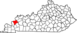
Midway is an unincorporated community in Crittenden County, Kentucky, United States. [2] [3]
This Crittenden County, Kentucky state location article is a stub. You can help Wikipedia by expanding it. |
Jeptha Knob is the highest point in the Bluegrass region of Kentucky. It is located on private property in Shelby County, Kentucky, about eight miles east of Shelbyville near the hamlet of Clay Village and rises some 300 ft higher than the surrounding rolling farmland.
Middleburg is a rural unincorporated community with a post office sitting just off the Green River in central Casey County, Kentucky, United States. The first land owner in the area was Abraham Lincoln I, the grandfather of president Abraham Lincoln, who purchased 800 acres (3.2 km2) in the area in 1784. In 1800, Lincoln transferred the land to Christopher Riffe.
Lebanon National Cemetery is a United States National Cemetery located just outside the city of Lebanon in Marion County, Kentucky. Administered by the United States Department of Veterans Affairs, it encompasses 14.8 acres (6.0 ha) and as of the end of 2005 it had 4,699 interments. It is administered by the Zachary Taylor National Cemetery.
Crittenden is a small hamlet in the town of Alden in Erie County, New York, United States. In 1910 the Crittenden Creamery was located on Crittenden Road north of Genesee Street, Route 33. On January 31, 2011, the Crittenden Post Office 14038 was closed after 160 years of service. It was located at 3610 Crittenden Road.
Cuba is an unincorporated community in Graves County, Kentucky, United States.
This is a list of the National Register of Historic Places listings in Trigg County, Kentucky.
Midway Corner is an unincorporated community in Crittenden County, Arkansas, United States. Midway Corner is located on Arkansas Highway 147, 8.2 miles (13.2 km) southwest of West Memphis.
Lindseyville is an unincorporated community located in Edmonson County, Kentucky, United States.
Beefhide is an unincorporated community spanning across a county line between Letcher County and Pike County, Kentucky, United States.
Tribune is an unincorporated community within Crittenden County, Kentucky, United States. It was also known as Hills Chapel.
Crayne is a census-designated place and unincorporated community within Crittenden County, Kentucky, United States. As of the 2010 census it had a population of 173.
Mattoon is an unincorporated community within Crittenden County, Kentucky, United States.
View is an unincorporated community within Crittenden County, Kentucky, United States.
Shady Grove is an unincorporated community within Crittenden County, Kentucky, United States.
Frances is an unincorporated community within Crittenden County, Kentucky, United States. It was also called Needmore.
Weston is an unincorporated community in Crittenden County, Kentucky, United States.
Seyppel is an unincorporated community in Crittenden County, Arkansas, United States.
Midway is an unincorporated community in Calloway County, Kentucky, United States.
Midway is an unincorporated community in Meade County, Kentucky, United States.
Dango is a ghost town located in southwestern Jackson County, Kentucky, United States. The town was located at the confluence of Racoon Creek and Horse Lick Creek, which flows into the Rockcastle River. It is located southwest of McKee by 8 miles, and 2.7 miles southeast of another ghost town, Loam. Near the confluence of the two creeks is the historical Carpenter School, which may be named after Carpenter Ridge, of which it is two miles south of. Heavy settlement and farming occurred in the area around Horse Lick Creek, where Dango was, until the early 1900s. The area where Dango was is currently occupied by the Daniel Boone National Forest, known as the Horse Lick Creek Biopreserve, with the majority of ownership being private.