
Attica, or the Attic Peninsula, is a historical region that encompasses the entire Athens metropolitan area, which consists of the city of Athens, the capital of Greece and the core city of the metropolitan area, as well as its surrounding suburban cities and towns. It is a peninsula projecting into the Aegean Sea, bordering on Boeotia to the north and Megaris to the west. The southern tip of the peninsula, known as Lavrio, was an important mining region.
Amaliada is a town and a former municipality in northwestern Elis, West Greece, Greece. Since the 2011 local government reform it is part of the municipality Ilida, of which it is the seat and a municipal unit. The municipal unit has an area of 251.945 km2. It is near the archaeological site of Elis, the city-state whose territory was the site of the ancient Olympic Games. It is situated in the plains of Elis, 6 km from the Ionian Sea. It is 10 km southeast of Gastouni, 16 km northwest of Pyrgos and 60 km southwest of Patras.

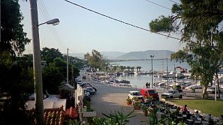
Rio is a town in the suburbs of Patras and a former municipality in Achaea, Western Greece, Greece. Since the 2011 local government reform it is part of the municipality Patras, of which it is a municipal unit. The municipal unit has an area of 98.983 km2. The municipal unit had a population of 14,219 in 2021. The campus of the University of Patras and the Casino Rio is located in Rio.

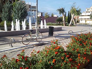
Anavyssos is a town and a former municipality in East Attica, Greece located in the Athens Riviera. Since the 2011 local government reform it is part of the municipality Saronikos, of which it is a municipal unit. The municipal unit has an area of 14.478 km2. At the 2021 census it had 6,180 inhabitants.

Methana is a town and a former municipality on the Peloponnese peninsula, Greece. Since the 2011 local government reform it is part of the municipality Troizinia-Methana, of which it is a municipal unit. The municipal unit has an area of 50.161 km2.

Agios Ioannis Renti is a suburb and a former municipality in the Piraeus regional unit, lying in the western part of the Athens agglomeration, Greece. Since the 2011 local government reform it is part of the municipality Nikaia-Agios Ioannis Renti, of which it is a municipal unit.

Agios Dimitrios is a town in Attica, Greece, and a suburb in the southern part of the Athens agglomeration.

Anoixi is a suburb of Athens in East Attica, Greece. Since the 2011 local government reform it is part of the municipality Dionysos, of which it is a municipal unit. The municipal unit has an area of 4.582 km2.
Dionysos is a northern suburb of the Athens agglomeration and a municipality in northeastern Attica, Greece. The seat of the municipality is the town Agios Stefanos.

Agios Stefanos is a town and a northern suburb of the Athens agglomeration, Greece. Since the 2011 local government reform it is part of the municipality of Dionysos, of which it is the seat and a municipal unit. The municipal unit has an area of 8.136 km2.

Sithonia, also known as Longos, is a peninsula and part of the larger peninsula of Chalkidiki in Greece. The Kassandra Peninsula lies to the west of Sithonia and the Mount Athos peninsula to the east. Sithonia is also the name of a municipality, covering the Sithonia Peninsula. The seat of the municipality is the town Nikiti.
Nea Makri is a town in East Attica, Greece. Since the local government reform of 2011, it has been a municipal unit within the municipality of Marathon. The municipal unit has an area of 36.662 km2. It is part of the Athens metropolitan area.

Mandra, is a town and former municipality in West Attica, Greece. Since the 2011 local government reform it is part of the municipality Mandra-Eidyllia, of which it is the seat and a municipal unit. The municipal unit has an area of 205.770 km2. The population of the municipal unit was 12,365 at the 2021 census.

Porto Rafti, officially named Limni Markopoulou, is a seaside resort town located in East Attica, Greece.
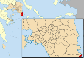
Lavreotiki is a municipality at the southeasternnmost tip of the Attica peninsula in the Greek regional unit of East Attica. Its municipal seat is the town of Laurium (Lavrio).
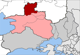
Erythres is a village and a former municipality in the northernmost part of West Attica, Greece. Since the 2011 local government reform it is part of the municipality Mandra-Eidyllia, of which it is a municipal unit. The municipal unit has an area of 61.145 km2. It is part of Athens metropolitan area. Erythres was named after the ancient city of Erythrae, the ruins of which are located 1.5 km east of the present town. The inhabitants of Erythres are Arvanites. The Greek National Road 3 passes through Erythres. The area south of Erythres is mountainous, with the Kithaironas to the southwest and the Pastra to the southeast. The area north of Erythres is characterised by the wide, flat valley of the Boeotian river Asopos, that flows to the east along the northern border of the municipal unit. This area is dominated by farmlands. Erythres is located 5 km east of Plataies, 6 km north of Vilia, 12 km south of Thebes and 44 km northwest of Athens.

Oinoi is a village and a former community in the northern part of West Attica, Greece. The village was named Mazi until 1919. Since the 2011 local government reform it is part of the municipality Mandra-Eidyllia, of which it is a municipal unit. The municipal unit has an area of 14.431 km2.

Aigosthena was an ancient Greek fortified port city of Megaris, 19 km (12 mi) northwest of the ancient city of Megara to which it belonged. It is also the name of the coastal settlement at the foot of the ancient city walls, also known as Porto Germeno. The ancient citadel which stands at the foot of Mt Cithaeron and extends down to the sea at the inlet of Aigosthena, on the east side of the Gulf of Corinth, is famous for retaining several of the tallest surviving towers of ancient Greece.
Milies is a village and a former municipality in Magnesia, Thessaly, Greece. Since the 2011 local government reform it is part of the municipality South Pelion, of which it is a municipal unit. The municipal unit has an area of 63.754 km2. It is a traditional Greek mountain village, at a height of 400 m on Mount Pelion. It is 28 km from Volos, the capital city of Magnesia. Milies is connected with the GR-34A It has traditional stone houses, cobbled roads, good restaurants and accommodation in abundance. Milies is also notable for being the terminus of the narrow gauge (60 cm) Pelion Railway, built between 1895 and 1903 by the Italian engineer, Evaristo de Chirico, father of the famous artist Giorgio de Chirico. This proved to be of considerable economic advantage to the region. The recently railway runs between Ano Lechonia and Milies twice a week at the weekend. The village commands striking views across the Pagasetic Gulf and benefits from the many streams and water sources for which Mt. Pelion is renowned. These result in rich vegetation and cool, forested mountain slopes.
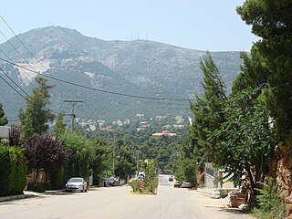
Pateras is a mountain of West Attica, Greece, with an elevation of 1,131 meters. Its highest peak is named Leontari. It is situated between the plain of Eleusis and the plain of Megara, and stretches between the Gulf of Corinth at Aigosthena and the Saronic Gulf near Eleusis. It is separated from its northern neighbour Cithaeron by the plain of Vilia. The mountain is covered with woods with Aleppo pine and Mediterranean maquis. In the tops of the mountain, that belong to a CORINE biotope, there are firs, of species Abies cephalonica.


