Villeta

Last updated
Villeta
City
Villeta municipalidad.jpg
Villeta, Paraguay
Paraguay adm location map.svg
Red pog.svg
Villeta
Coordinates: 25°30′36″S57°33′36″W / 25.51000°S 57.56000°W / -25.51000; -57.56000 Coordinates: 25°30′36″S57°33′36″W / 25.51000°S 57.56000°W / -25.51000; -57.56000
Country Paraguay
Department Central
FoundedMarch 5th 1714
Government
   Intendente Municipal Teodosio Gómez Ibáñez (PLRA)
Area
  Total888 km2 (343 sq mi)
Elevation
55 m (180 ft)
Population
 (2016)
  Total36,985
  Density25/km2 (60/sq mi)
Time zone -4 Gmt
Postal code
2680
Area code +595 225
Climate Cfa

Villeta is a city of Paraguay in the Central Department, on the banks of Paraguay River. It is an important industrial center and port.

Contents

Toponymy

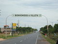
The city was founded on March 5, 1714, by Juan Gregorio Bazán de Pedraza, with the original name of San Felipe de Borbón del Valle del Bastán (Saint Philip of Bourbon of the Valley of Bastán), in homage to the King Felipe II. It was later renamed Villeta because of its resemblance to a great Villa.

Villeta's Port

The port is administered by the National Administration for Navigation and Ports (ANNP), and is specially equipped for the handling of heavy machinery. Many different kinds of merchandise are traded through this port. In Villeta, there's also the Caacupé-mí Port, one of the most important private ports in Paraguay. [1]

Characteristics:

Climate

The temperature in summer sometimes reaches 40 °C or higher. The minimum in winter is 0 °C. The average for the entire Central Department is 22 °C. The city is located in one of Paraguay's departments with the most rainfall during the months from January to April; and the least during the months from June to August.

Demography

The total population of the city is 36,228 inhabitants, 18,362 males and 17,866 females, according to the data from the General Directorate of Statistics, Polls and Census.

History

Villeta was founded in 1714 by the Governor Juan Gregorio Bazán de Pedraza. During the government of Dr. Francia, the city became an important conduit for communication with other countries, making the economic development of the district possible.

Economy

Until 1930 the city was famous because of activity at the port, mostly the export of oranges. Today the port is used for multiple purposes.

Villeta's port on the banks of the Paraguay River is the shipping point for most of Paraguay's exports. Nineteen large factories located in the area produce cement, iron rods, cotton, electric cables, and agricultural chemicals, and other activities. The cement and chemical plants are infamous for the environmental contamination they cause.

The major processing plant for Paraguay's cement industry is located in Villeta.

Tourism

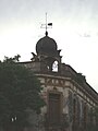
Located in the Gran Asunción Area, there are several historic buildings in the city of Villeta. The Church of the Virgin of the Rosary (Virgen del Rosario), built during the period of the Paraguayan War also served as a Hospital, and is one such edifice. The architecture of the church is an example of the distinctive characteristics of 19th-century art in Paraguay, especially in the murals painted by Adán Kunos.

Fishing can be enjoyed in Guyrati, Angostura and Itaipiru, near Argentina.

Notable people

Famous residents of Villeta include:

How to get to Villeta

Through the Southern Access Route. (Part of the Route 1). Villeta is 34 kilometers south of Asunción. The Villeta–AlberdiPilar Route also connects the city to the south of the country.

Related Research Articles

Paraguay's transportation system ranges from adequate to poor, largely depending on the region of the country. The country has a network of roads, railroads, rivers, and airports, but significant infrastructure and regulation improvements are needed.

<span class="mw-page-title-main">Amambay Department</span> Department of Paraguay

Amambay is a department in Paraguay. The capital is Pedro Juan Caballero.

<span class="mw-page-title-main">Caaguazú Department</span> Department of Paraguay

Caaguazú is a department in Paraguay. The capital is the city of Coronel Oviedo.

<span class="mw-page-title-main">Central Department</span> Department of Paraguay

Central is a department in Paraguay. The capital is Areguá. With 2,243,792 inhabitants, it is the most populated and the smallest of the 17 departments of Paraguay.

<span class="mw-page-title-main">Concepción Department, Paraguay</span> Department of Paraguay

Concepción is a department of Paraguay. The capital is the city of Concepción.

<span class="mw-page-title-main">Cordillera Department</span> Department of Paraguay

Cordillera is a department in Paraguay. The capital is the city of Caacupé.

<span class="mw-page-title-main">Humaitá</span> Place in Ñeembucú, Paraguay

Humaitá is a town and distrito on the Paraguay River in southern Paraguay. During the Paraguayan War, it served as the main Paraguayan stronghold from 1866 until its fall in August 1868. Up to 24,000 troops were housed there at one point. It served as the de facto residence of the Paraguayan government until March 1868.

Primero de Marzo is a small town and district in the marshy lowlands of the Cordillera Department in Paraguay. The area is located near the shallow meandering river Yhaguy which locals utilize primarily for fishing and recreation. Primero de Marzo's name is derived from the date March 1, 1870, when then Paraguayan President Francisco Solano López was killed by Brazilian troops at Cerro Corá, thereby ending the bloody War of the Triple Alliance.

<span class="mw-page-title-main">Yaguarón</span> City in Paraguarí, Paraguay

Yaguarón is a city in Paraguay, located at the base of Yaguarón Hill in the Yaguarón District of Paraguarí Department, 48 kilometres (30 mi) from the capital Asunción. The town began as a Franciscan reservation for the Guaraní Indians.

<span class="mw-page-title-main">Altos, Paraguay</span> City & District in Cordillera, Paraguay

Altos is a city and district of the Cordillera Department, Paraguay.

Carapeguá is a city and district of the Paraguarí Department, Paraguay, located 84 km from Asunción. It was founded in 1725.

<span class="mw-page-title-main">Alberdi, Paraguay</span> City in Ñeembucú, Paraguay

Alberdi is the city in the Ñeembucú Department of Paraguay. It is 144 km (89 mi) south of the capital city, Asunción.

Caraguatay, Guaraní: Karaguatay) is a distrito and town located in the Vapor Cué region of the Cordillera Department in Paraguay. The livelihood of most citizens includes farming, fishing, and local trading.

<span class="mw-page-title-main">Fernando de la Mora, Paraguay</span> City in Central, Paraguay

Fernando de la Mora is a city located in the Central Department, and is part of the metropolitan area of Asunción, in Paraguay. With an estimated of 183,390 inhabitants, the city is the seventh most populated of the country.

<span class="mw-page-title-main">Roman Catholic Archdiocese of Asunción</span> Roman Catholic archdiocese in Paraguay

The Roman Catholic Archdiocese of Asunción is an ecclesiastical territory or diocese of the Roman Catholic Church in Paraguay.

<span class="mw-page-title-main">Villa Florida</span> Place in Misiones, Paraguay

Villa Florida is a city in southern Paraguay located on the Tebicuary River at the entrance of Misiones Region. Initially, when it was established by the Jesuits in 1632, it was called Paso Santa María. It was officially founded as a city on September 6, 1880 during Bernardino Caballero's government.

Curuguaty is a city and a district in the Canindeyú Department of Paraguay, that was the 4th and last capital of Paraguay during the Paraguayan War in 1869–1870.

Horqueta is a city of Paraguay, in the department of Concepción, located 50 kilometers from Concepción City and 428 kilometers from Asunción. It is established in a hill.

Ñumí is a district of the Guairá Department, Paraguay.

San Salvador is a district of the Guairá Department, Paraguay.

References

  1. "Caacupe-mí Port – Caacupe-mí Port".