
Interstate 10 (I-10) is the southernmost transcontinental highway in the Interstate Highway System. I-10 is the fourth-longest Interstate in the United States at 2,460.34 miles (3,959.53 km), following I-90, I-80, and I-40. This freeway is part of the originally planned network that was laid out in 1956, and its last section was completed in 1990.
U.S. Highway 175 (US 175) is a 111.0-mile (178.6 km) east-west United States Numbered Highway located completely within the state of Texas. It comes very close to meeting its parent route, US 75, but decommissioning and rerouting in Downtown Dallas leaves it short a couple of miles. Before the decommissioning of US 75 south of downtown Dallas in favor of Interstate 45 (I-45), US 175 met US 75. US 175's western terminus is in Dallas at I-45. The highway's eastern terminus is in Jacksonville at an intersection with US 69.

U.S. Route 340 is a spur route of US 40, and runs from Greenville, Virginia, to Frederick, Maryland. In Virginia, it runs north–south, parallel and east of US 11, from US 11 north of Greenville via Waynesboro, Grottoes, Elkton, Luray, Front Royal, and Berryville to the West Virginia state line. A short separate piece crosses northern Loudoun County on its way from West Virginia to Maryland.

State Route 620 in Fairfax and Loudoun Counties, Virginia is a secondary state highway. The entire length of SR 620 is also known as Braddock Road. SR 620 also has a short concurrency with SR 659 / Union Mill Road in Centreville.

Virginia State Route 7 (VA 7) is a major primary state highway and busy commuter route in northern Virginia, United States. It travels southeast from downtown Winchester to SR 400 in downtown Alexandria. Its route largely parallels those of the Washington & Old Dominion Trail and the Potomac River. Between its western terminus and Interstate 395 (I-395), SR 7 is part of the National Highway System. In 1968, the Virginia State Highway Commission designated the road as the "Harry Flood Byrd Highway" between Alexandria and Winchester to commemorate Harry F. Byrd Sr. (1887–1966).
State Route 7 (SR 7), formerly known as Inter-county Highway 7 until 1921 and State Highway 7 in 1922, is a north–south state highway in the southern and eastern portions of the U.S. state of Ohio. At about 336 miles (541 km) in length, it is the longest state route in Ohio. Its southern terminus is an interchange with U.S. Route 52 (US 52) just west of Chesapeake. Its northern terminus also serves as the eastern terminus of SR 531 in Conneaut. The path of SR 7 stays within five miles (8.0 km) of the Ohio River for the southern portion, with the river being visible from much of the route. The road also remains within 10 miles (16 km) of the Pennsylvania state line for the northern portion.

State Route 28 in the U.S. state of Virginia is a primary state highway that traverses the counties of Loudoun, Fairfax, Prince William, and Fauquier in the U.S. state of Virginia. The route serves as a major artery in the Northern Virginia region, with it being an important two-lane highway in rural Fauquier and Prince William Counties, the main thoroughfare through Manassas and Manassas Park, and a high-capacity freeway through Fairfax and Loudoun Counties.
Arcola is a census-designated place in Loudoun County, Virginia, United States. The population as of the 2010 United States Census was 233.
Stone Ridge is a census-designated place in Loudoun County, Virginia, United States. Residences use Aldie mailing addresses, and it is near Washington Dulles International Airport. The population as of the 2020 census was 15,039. Stone Ridge is a Van Metre Homes planned, mixed-use community.

U.S. Route 50 is a transcontinental highway which stretches from Ocean City, Maryland to West Sacramento, California. In the U.S. state of Virginia, US 50 extends 86 miles (138 km) from the border with Washington, D.C. at a Potomac River crossing at Rosslyn in Arlington County to the West Virginia state line near Gore in Frederick County.
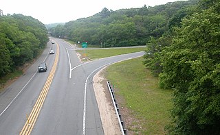
A two-lane expressway or two-lane freeway is an expressway or freeway with only one lane in each direction, and usually no median barrier. It may be built that way because of constraints, or may be intended for expansion once traffic volumes rise. The term super two is often used by roadgeeks for this type of road, but traffic engineers use that term for a high-quality surface road. Most of these roads are not tolled.

State Route 388 (SR 388) is a 4.5-mile-long (7.2 km) state highway that travels south-to-north in a backward L-shape, completely within Columbia County, in the east-central part of the state of Georgia. It connects Grovetown to Lewiston.

Virginia State Route 9 is a primary state highway in the U.S. state of Virginia. Known as Charles Town Pike, the state highway runs 13.08 miles (21.05 km) from the West Virginia state line near Mechanicsville, where the highway continues west as West Virginia Route 9, east to SR 7 and SR 7 Business in Paeonian Springs. SR 9 is the main east–west highway of northwestern Loudoun County, connecting Leesburg with Hillsboro and the West Virginia cities of Charles Town and Martinsburg. As a result, the state highway and its West Virginia continuation are a major, overburdened commuter route between the Eastern Panhandle of West Virginia and Washington, D.C.

Virginia State Route 234 is a primary state highway in the U.S. state of Virginia. It runs from U.S. Route 1 near Dumfries via Independent Hill as Dumfries Road, bypasses Manassas as Prince William Parkway, and has a brief concurrency with Interstate 66 for 2.27 miles (3.65 km) between exits 44 and 47 before continuing northwest via Catharpin to U.S. Route 15 near Woolsey as Sudley Road.
The Prince William Parkway is a road in Prince William County, Virginia. The road carries two designations. Starting in the east at the intersection with U.S. Route 1 (US 1) in Woodbridge to the west until intersecting with Dumfries Road south of Manassas, it carries State Route 294. At Dumfries Road, the Prince William Parkway assumes the SR 234 designation until ending at Interstate 66 (I-66) near Gainesville.
State Highway 83 (SH 83) is a state highway that is located along the Front Range in the U.S. State of Colorado. Spanning about 56.2 miles (90.4 km) from the SH 21 interchange in northern Colorado Springs and SH 2 in Denver, the highway follows a south–north route, paralleling Interstate 25 to the east and serving rural areas. Along with I-25, it is one of the only two routes in the Colorado State Highway System that directly connects Denver and Colorado Springs.

State Route 606 in Fairfax and Loudoun Counties, Virginia is a secondary state highway traversing the communities of Reston, Herndon, Sterling, Arcola, and South Riding. The road is important not only because it is an inter-county connector, but it goes around the back of Dulles Airport, is part of the Loudoun County Parkway, and it provides a shortcut between the Reston / Herndon area and U.S. Route 50. Although the Herndon streets are not technically part of SR 606, they are signed as SR 606, and they connect to streets that are part of SR 606, thus providing a continuous route.

U.S. Route 231 in Kentucky runs 114 miles (183 km) from the Tennessee state line near Adolphus to the William H. Natcher Bridge on the Ohio River near Rockport, Indiana. It crosses the state mainly in the west-central region, traversing Allen, Warren, Butler, Ohio, and Daviess Counties.
Virginia HOT lanes refers to seven separate projects in the U.S. state of Virginia.

U.S. Highway 63 (US 63) is a part of the United States Numbered Highway System that spans 1,286 miles (2,070 km) from Ruston, Louisiana to a point southwest of Ashland, Wisconsin. Within the state of Louisiana, the highway travels 35.40 miles (56.97 km) from the national southern terminus at the junction of Interstate 20 (I-20), US 167, and Louisiana Highway 146 (LA 146) in Ruston to the Arkansas state line at Junction City.
