Arcola, Virginia

Last updated

Arcola, Virginia
USA Virginia Northern location map.svg
Red pog.svg
Arcola
USA Virginia location map.svg
Red pog.svg
Arcola
Usa edcp location map.svg
Red pog.svg
Arcola
Coordinates: 38°57′6″N77°32′3″W / 38.95167°N 77.53417°W / 38.95167; -77.53417
CountryFlag of the United States.svg  United States
State Flag of Virginia.svg  Virginia
County Loudoun
Area
[1]
  Total2.31 sq mi (5.98 km2)
  Land2.29 sq mi (5.92 km2)
  Water0.02 sq mi (0.06 km2)
Elevation
285 ft (87 m)
Population
 (2010) [2]
  Total233
  Density102/sq mi (39.4/km2)
Time zone UTC−5 (Eastern (EST))
  Summer (DST) UTC−4 (EDT)
ZIP code
20166
FIPS code 51-02248
GNIS feature ID1492481

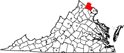
Arcola is a census-designated place in Loudoun County, Virginia, United States. The population as of the 2010 United States Census was 233. [2]

Contents

Geography

Arcola is in southeastern Loudoun County, on the north side of U.S. Route 50, which leads east 31 miles (50 km) to Washington, D.C., and northwest 42 miles (68 km) to Winchester. Leesburg, the Loudoun county seat, is 14 miles (23 km) north of Arcola, and the southwest runway of Washington Dulles International Airport is less than 3 miles (5 km) to the east.

According to the U.S. Census Bureau, the Arcola CDP has a total area of 2.3 square miles (6.0 km2), of which 0.02 square miles (0.06 km2), or 0.97%, are water. [1] Arcola village is in the northern part of the CDP, along the South Fork of Broad Run, a north-flowing tributary of the Potomac River.

History

The genesis of Arcola was a small spring next to a gum tree that fed into the south fork of Broad Run, suitably called "Gum Springs". During the colonial era a distillery, kiln and small church were established at the spring.

When Cameron Parish was established from Truro Parish, its glebe, the area reserved to support the parish priest, was established just northwest of the spring. The glebelands were sold off in 1802 when the Virginia General Assembly divested all Anglican glebes.

In 1801 the United States Post Office established a branch at the village, naming it "Springfield". The branch closed in 1819. Thirteen years later the Post Office once again saw fit to locate a branch in the vicinity, but the success of the Little River Turnpike (present day U.S. Route 50) dictated that it would be located on that road south of the village and known on local maps as simply "Arcola P.O." (situated near the present-day intersection of US 50 and Hwy 616/Fleetwood Rd). The branch was named "Arcola" in honor of the Arcola Farm on which it was built. That branch stayed open until 1868, when the office was located back within the confines of the village. The village itself, however, remained identified on local maps as "Gum Spring" during most of the 19th century.

In the 1850s Arcola had a brush with the big time when the construction of the Loudoun Branch of the Manassas Gap Railroad was completed on the northern border of the village. Unfortunately the Panic of 1857 and Civil War stopped the railroad from ever being used. During the Gettysburg Campaign of June–July 1863, troops from the Union Army of the Potomac's 11th and 1st Corps marched and camped in and around the town of "Gum Spring" according to dispatches (present-day Arcola), as they meandered north toward Leesburg and into Maryland.

Unlike many other Loudoun villages, Arcola continued to grow well into the twentieth century. In 1876 the population was 30, in 1911 it was 90 and by 1976 it was 135.

John Franklin Ryan (18481936), former representative in the Virginia House of Delegates, is buried in the Darnes Cemetery in Arcola.

The Arcola Elementary School, Arcola Slave Quarters, and Fleetwood Farm are listed on the National Register of Historic Places. [3] [4]

Related Research Articles

<span class="mw-page-title-main">Leesburg, Virginia</span> Town in Virginia, United States

Leesburg is a town in and the county seat of Loudoun County, Virginia, United States. Settlement in the area began around 1740, which is named for the Lee family, early leaders of the town. Located in the far northeast of the state, in the War of 1812 it was a refuge for important federal documents evacuated from Washington, DC, and in the Civil War, it changed hands several times.

<span class="mw-page-title-main">Lovettsville, Virginia</span> Town in Virginia

Lovettsville is a town in Loudoun County, located near the very northern tip of the Commonwealth of Virginia, United States. Settled primarily by German immigrants, the town was originally established in 1836.

<span class="mw-page-title-main">Purcellville, Virginia</span> Small Town in Virginia

Purcellville is a town in Loudoun County, Virginia. The population was 8,929 according to the 2020 Census. Purcellville is the major population center for Western Loudoun and the Loudoun Valley. Many of the older structures remaining in Purcellville reflect the Victorian architecture popular during the early twentieth century.

<span class="mw-page-title-main">Round Hill, Loudoun County, Virginia</span> Town in Virginia

Round Hill is a town in Loudoun County, Virginia, United States. Its population was 539 at the 2010 census and an estimated 656 in 2019. The town is located at the crossroads of Virginia Routes 7 and 719, approximately 50 miles (80 km) northwest of Washington, D.C. The town's name refers a hill two miles northeast of a 910-foot (280 m) hill used during the American Civil War as a signal post by both Confederate and Union troops. House of Round Hill was built in 2004. Patsy Cline went to Round Hill Elementary School.

<span class="mw-page-title-main">Sterling, Virginia</span> Census-designated place in Virginia

Sterling, Virginia, refers most specifically to a census-designated place (CDP) in Loudoun County, Virginia, United States. The population of the CDP as of the 2020 United States Census was 30,337 The CDP boundaries are confined to a relatively small area between Virginia State Route 28 on the west and Virginia State Route 7 on the northeast, excluding areas near SR 606 and the Dulles Town Center.

<span class="mw-page-title-main">South Riding, Virginia</span> Census-designated place in Virginia

South Riding is a census-designated place and planned community in Loudoun County, Virginia, United States. The South Riding homeowner association was founded in January 1995 to provide services to the community. Neighboring U.S. Route 50 and State Route 28 provide access to the Dulles/Reston/Tysons Corner technology corridor and other major employment centers in Northern Virginia and Washington, D.C.

<span class="mw-page-title-main">Brambleton, Virginia</span> Census-designated place in Virginia

Brambleton is a census-designated place (CDP) in Loudoun County, Virginia, United States, south of the Dulles Greenway. The population as of the 2010 United States Census was 9,845. In 2017, Brambleton had an estimated population of 19,900, with a median age of 34.3 and a median household income of $173,690. Between 2016 and 2017 the population of Brambleton, VA grew from 17,063 to 19,876, a 16.5% increase and its median household income grew from $164,321 to $173,690, a 5.7% increase. Construction started on the Brambleton community in 2001.

Stone Ridge is a census-designated place in Loudoun County, Virginia, United States. Residences use Aldie mailing addresses, and it is near Washington Dulles International Airport. The population as of the 2020 census was 15,039. Stone Ridge is a Van Metre Homes planned, mixed-use community.

Lansdowne is a census-designated place and planned community located near Leesburg, Virginia in Loudoun County, Virginia. The population as of the 2010 United States Census was 11,253. It is north of State Route 7 and south of the Potomac River. Before the Revolutionary War, the Lee family established Coton Manor here. A section of the Potomac Heritage Trail runs through Lansdowne. It is the home of Inova Loudoun Hospital, the Jack Kent Cooke Foundation, Lansdowne Resort, Prison Fellowship, and Lansdowne Woods of Virginia, a gated, age-restricted community.

Belmont is a census-designated place (CDP) in Loudoun County, Virginia, United States. The population as of the 2010 United States Census was 5,966. It is 5 miles (8 km) southeast of Leesburg, the Loudoun county seat, and 31 miles (50 km) northwest of Washington, D.C. The Belmont Manor House, built between 1799 and 1802 by a son of Richard Henry Lee, is in the northeast part of the CDP and is now the clubhouse for a gated golf community.

<span class="mw-page-title-main">Goose Creek (Potomac River tributary)</span> River in Virginia, United States

Goose Creek is a 53.9-mile-long (86.7 km) tributary of the Potomac River in Fauquier and Loudoun counties in northern Virginia. It comprises the principal drainage system for the Loudoun Valley.

<span class="mw-page-title-main">Broadlands, Virginia</span> Census-designated place in Virginia

Broadlands is a census-designated place (CDP) in Loudoun County, Virginia, United States. It is a 1,500-acre (610 ha) master-planned community started and developed by Van Metre Homes in the 1990s. It is built on wetlands and is certified as a Community Wildlife Habitat by the National Wildlife Federation.

<span class="mw-page-title-main">Countryside, Virginia</span> Census-designated place in Virginia

Countryside is a census-designated place in Loudoun County, Virginia, United States. The population as of the 2010 census was 10,072. It is located about 27 miles (43 km) northwest of Washington and is bounded by the Potomac River to the north, and by Route 7 to the south. Located in eastern Loudoun County, it is about 9 miles (14 km) north of Washington Dulles International Airport. It is bordered by the community of Cascades to the east and by Dulles Town Center to the south, across Route 7.

<span class="mw-page-title-main">Virginia State Route 659 (Loudoun and Prince William Counties)</span>

State Route 659 in Loudoun and Prince William Counties, Virginia is a secondary state highway. Otherwise known as Belmont Ridge Road north of Arcola, and Gum Spring Road to the south, the road is heavily used by commuters in the suburbs and bedroom communities of Loudoun County.

<span class="mw-page-title-main">Broad Run (Loudoun County, Virginia)</span> River in Virginia, United States

Broad Run is a tributary of the Potomac River in Loudoun County, Virginia. The creek, located between Goose Creek and Sugarland Run, principally drains portions of eastern Loudoun County, as well as a small portion of western Fairfax County.

<span class="mw-page-title-main">Dulles Town Center, Virginia</span> Census-designated place in Virginia

Dulles Town Center is a census-designated place (CDP) in Loudoun County, Virginia, United States. It is located about 7 miles (11 km) north of Washington Dulles International Airport. The CDP is the location of the Dulles Town Center shopping mall, for which it is named. The United States Postal Service considers Dulles Town Center to be a subsection of Dulles, which is itself a subsection of Sterling; none of these locations is an incorporated municipality.

Lowes Island is a census-designated place (CDP) in Loudoun County, Virginia, United States. The population as of the 2010 United States Census was 10,756. Along with nearby Countryside and Cascades, it is considered one of the three main components of the Potomac Falls community.

<span class="mw-page-title-main">Moorefield, Virginia</span> Census-designated place in Virginia

Moorefield is a census-designated place (CDP) in Loudoun County, Virginia, United States. As of the 2010 census, the CDP was named Moorefield Station, and the population was 77. As of 2019, the estimated population was 1,976. Moorefield is a mixed-use development currently in progress, located at the Ashburn station at the western terminus of the Metrorail Silver Line.

University Center is a census-designated place (CDP) in Loudoun County, Virginia, United States. The population as of the 2010 United States Census was 3,586. Mailing addresses in the community are for Ashburn.

Goose Creek Village is a census-designated place (CDP) in Loudoun County, Virginia, United States. It was first drawn as a CDP prior to the 2020 census.

References

  1. 1 2 "2020 U.S. Gazetteer Files –Virginia". United States Census Bureau. Retrieved February 19, 2021.
  2. 1 2 "Total Population: 2010 Census DEC Summary File 1 (P1), Arcola CDP, Virginia". data.census.gov. U.S. Census Bureau. Retrieved February 19, 2021.
  3. "National Register Information System". National Register of Historic Places . National Park Service. July 9, 2010.
  4. "National Register of Historic Places Listings". Weekly List of Actions Taken on Properties: 6/03/13 through 6/07/13. National Park Service. June 14, 2013.