Lucketts, Virginia | |
---|---|
Coordinates: 39°12′56″N77°32′4″W / 39.21556°N 77.53444°W | |
Country | United States |
State | Virginia |
County | Loudoun |
Time zone | UTC−5 (Eastern (EST)) |
• Summer (DST) | UTC−4 (EDT) |
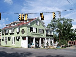
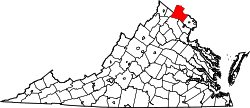
Lucketts is an unincorporated historic hamlet in Loudoun County, Virginia, along U.S. Route 15 north of Leesburg. It was originally known as "Black Swamp" due to the large number of black oak trees growing in the area at the time of its settlement. From the late 18th century until the mid-19th century, it was known as "Goresville" after the name of prominent local landowner, Thomas Gore. The name was finally changed to "Lucketts" in 1865. The town's Lucketts School is listed on the National Register of Historic Places.
Lucketts is approximately 7 miles (11 km) north of Leesburg and 18 miles (29 km) south of Frederick, Maryland. The Potomac River is between Lucketts and Frederick, approximately 4 miles (6 km) north on Route 15. The MARC commuter train makes frequent stops on the Maryland side in Point of Rocks. Train whistles of the freight trains at night and dawn are frequently heard throughout Lucketts.
The village of Lucketts is visually cued by the traffic light at the intersection of Route 15, Lucketts Road, and Stumptown Road. Located there are antique stores, a gas station, a few residential homes and trailer parks, fire house, Lucketts Elementary School, and a cell phone tower. The Lucketts School, now the Lucketts Community Center, is listed on the National Register of Historic Places. Traffic going through Lucketts on Route 15 was approximately 18,000 to 21,000 vehicles per day as of 2005. [1]
Lucketts is known for its annual fair in August, with crafts, food and hand-churned ice cream sold by the Lucketts Elementary School PTA. The Lucketts Community Center, located in the original wooden Lucketts School has a day care service, pre-school, adult activities, and since 1974, bluegrass concerts every Saturday night at 7:00 PM from October through April. [2]
The National Road was the first major improved highway in the United States built by the federal government. Built between 1811 and 1837, the 620-mile (1,000 km) road connected the Potomac and Ohio Rivers and was a main transport path to the West for thousands of settlers. When improved in the 1830s, it became the second U.S. road surfaced with the macadam process pioneered by Scotsman John Loudon McAdam.
Interstate 68 (I-68) is a 112.9-mile (181.7 km) Interstate Highway in the US states of West Virginia and Maryland, connecting I-79 in Morgantown, West Virginia, east to I-70 in Hancock, Maryland. I-68 is also Corridor E of the Appalachian Development Highway System. From 1965 until the freeway's construction was completed in 1991, it was designated as U.S. Route 48 (US 48). In Maryland, the highway is known as the National Freeway, an homage to the historic National Road, which I-68 parallels between Keysers Ridge and Hancock. The freeway mainly spans rural areas and crosses numerous mountain ridges along its route. A road cut at Sideling Hill exposed geological features of the mountain and has become a tourist attraction.
Cumberland is a city in and the county seat of Allegany County, Maryland, United States. At the 2020 census, the city had a population of 19,076. Located on the Potomac River, Cumberland is a regional business and commercial center for Western Maryland and the Potomac Highlands of West Virginia. It is the primary city of the Cumberland metropolitan area, which had 95,044 residents in 2020.
Odenton is a census-designated place (CDP) in Anne Arundel County, Maryland, United States, located approximately 10–20 minutes from the state capital, Annapolis. The population was 37,132 at the 2010 census, up from 20,534 at the 2000 census. The town's population growth rate of 80.8% between 2000 and 2010 was the greatest of any town in western Anne Arundel County. Odenton is located west of Annapolis, south of Baltimore, and northeast of Washington.
Warrenton is a town in Fauquier County, Virginia, of which it is the seat of government. The population was 10,057 as of the 2020 census, an increase from 9,611 at the 2010 census and 6,670 at the 2000 census. The estimated population in July 2021 was 10,109. It is at the junction of U.S. Route 15, U.S. Route 17, U.S. Route 29, and U.S. Route 211. The town is in the Piedmont region of Virginia just east of the Blue Ridge Mountains. The well-known Airlie Conference Center is 3 miles (5 km) north of Warrenton, and the historic Vint Hill Farms military facility is 9 miles (14 km) east. Fauquier Hospital is located in the town. Surrounded by Virginia wine and horse country, Warrenton is a popular destination outside Washington, D.C.
Hillsboro is a rural town in Loudoun County, Virginia, United States. The population was 80 at the 2010 census and an estimated 169 as of 2019.
Leesburg is a town in and the county seat of Loudoun County, Virginia, United States. Settlement in the area began around 1740, which is named for the Lee family, early leaders of the town. Located in the far northeast of the state, in the War of 1812 it was a refuge for important federal documents evacuated from Washington, DC, and in the Civil War, it changed hands several times.
Purcellville is a town in Loudoun County, Virginia. The population was 8,929 according to the 2020 Census. Purcellville is the major population center for Western Loudoun and the Loudoun Valley. Many of the older structures remaining in Purcellville reflect the Victorian architecture popular during the early twentieth century.
Round Hill is a town in Loudoun County, Virginia, United States. Its population was 539 at the 2010 census and an estimated 656 in 2019. The town is located at the crossroads of Virginia Routes 7 and 719, approximately 50 miles (80 km) northwest of Washington, D.C. The town's name refers a hill two miles northeast of a 910-foot (280 m) hill used during the American Civil War as a signal post by both Confederate and Union troops. House of Round Hill was built in 2004. Patsy Cline went to Round Hill Elementary School.
U.S. Route 340 is a spur route of US 40, and runs from Greenville, Virginia, to Frederick, Maryland. In Virginia, it runs north–south, parallel and east of US 11, from US 11 north of Greenville via Waynesboro, Grottoes, Elkton, Luray, Front Royal, and Berryville to the West Virginia state line. A short separate piece crosses northern Loudoun County on its way from West Virginia to Maryland.
The Capital Beltway is a 64-mile (103 km) auxiliary Interstate Highway in the Washington metropolitan area that surrounds Washington, D.C., the capital of the United States, and its inner suburbs in adjacent Maryland and Virginia. It is the basis of the phrase "inside the Beltway", used when referring to issues dealing with US federal government and politics. The highway is signed as Interstate 495 (I-495) for its entire length, and its southern and eastern half runs concurrently with I-95.
State Route 193 is a primary state highway in the U.S. state of Virginia. Known as Georgetown Pike, the state highway runs 11.79 mi (18.97 km) from SR 7 in Dranesville east to SR 123 in Langley. SR 193 passes through Great Falls and meets Interstate 495 (I-495) in McLean. The state highway was designated the first Virginia Byway for its scenic value in 1974.
Taylorstown is a small community in Loudoun County, Virginia, built on the banks of Catoctin Creek and the surrounding hillside, about two miles (3 km) south of the Potomac River. First settled in 1734, it holds two of the oldest standing houses in Loudoun County, "Hunting Hill" and "Foxton Cottage", directly across the Catoctin Creek from each other.
Arcola is a census-designated place in Loudoun County, Virginia, United States. The population as of the 2010 United States Census was 233.
The Battle of Mile Hill was a cavalry skirmish during the American Civil War, that took place just north of Leesburg, Virginia, on September 2, 1862. It preceded the occupation of the town by the Army of Northern Virginia just prior to its crossing of the Potomac River starting the Maryland Campaign.
U.S. Route 15 (US 15) is a part of the United States Numbered Highway System that runs from Walterboro, South Carolina, to Painted Post, New York. In Virginia, the U.S. Highway runs 230.37 miles (370.74 km) from the North Carolina state line near Clarksville north to the Maryland state line at the Potomac River near Lucketts. US 15 is a major north–south highway through the Piedmont of Virginia, connecting Clarksville and Farmville in Southside with Culpeper, Warrenton, and Leesburg in Northern Virginia.
Nolands Ferry I Archeological Site is an archaeological site near the historic Noland's Ferry boat landing at mile 44.58 on the C&O Canal and Tuscarora. The Archeological Site is a prehistoric occupation site located in the Monocacy region of southern Frederick County, Maryland. Diagnostic artifacts at the site indicate that the site was almost continuously inhabited from the Paleo-Indian period to the early 19th century, with the most substantial inhabitation occurring during the Late Woodland period.
Hagerstown is a city in and the county seat of Washington County, Maryland, United States. The population was 43,527 at the 2020 census. Hagerstown ranks as Maryland's sixth-largest incorporated city and is the largest city in the Maryland Panhandle.
Several special routes of U.S. Route 15 (US 15) exist. In order from south to north, they are as follows.
The Carolina Road or the "Old Carolina Road" are names for various sections of the Great Wagon Road and other routes in colonial America. "The 'Old Carolina Road', extending from Lancaster, Pennsylvania to the Yadkin Valley, was one of the most heavily traveled roads in eighteenth century America." Parts of the 180-mile-long (290 km) Journey Through Hallowed Ground National Heritage Area scenic byway follow the Old Carolina Road through Pennsylvania, Maryland and Virginia.