Cascades, Virginia

Last updated

Cascades, Virginia
CascadesMarketCenter.jpg
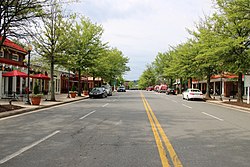
The Cascades Marketplace, designed with a "main street" aesthetic
USA Virginia Northern location map.svg
Red pog.svg
Cascades
USA Virginia location map.svg
Red pog.svg
Cascades
Usa edcp location map.svg
Red pog.svg
Cascades
Coordinates: 39°2′54″N77°23′1″W / 39.04833°N 77.38361°W / 39.04833; -77.38361
CountryFlag of the United States.svg  United States
State Flag of Virginia.svg  Virginia
County Flag of Loudoun County, Virginia.svg Loudoun
Area
[1]
  Total3.75 sq mi (9.71 km2)
  Land3.69 sq mi (9.55 km2)
  Water0.06 sq mi (0.16 km2)
Elevation
270 ft (80 m)
Population
 (2010) [2]
  Total11,912
  Density3,232/sq mi (1,247.8/km2)
Time zone UTC−5 (Eastern (EST))
  Summer (DST) UTC−4 (EDT)
ZIP code
20165
Area code(s) 703 and 571
FIPS code 51-13403
GNIS feature ID2584825

Cascades is a census-designated place (CDP) in Loudoun County, Virginia, United States. The population as of the 2010 United States Census was 11,912. [2] Along with nearby Countryside and Lowes Island, it is considered one of the three main components of the Potomac Falls community (ZIP code 20165) within Sterling, Virginia.

Contents

Cascades is a planned community of 2,500 acres (1,000 ha) with approximately 6,500 homes. The corresponding homeowners association was incorporated on November 8, 1990. [3] [4] As in nearby Sterling Park, prior to the establishment of the Cascades community in 1990 the area was made up of a few very large farms. The homeowners association maintains five community centers, five swimming pools, 15 tennis courts, and other amenities including extensive paved walking trails. The Lowes Island at Cascades community (commonly referred to as Lowes Island) is an advertised portion of the legal subdivision of Cascades, but is not a legal subdivision itself. The Lowes Island community is centered on Trump National Golf Club Washington, D.C., formerly Lowes Island Country Club. [5] The Cascades development is bordered on the north by the Potomack Lake Sportsplex [6] and Algonkian Regional Park (which abuts the Potomac River); both facilities are included in the Cascades census-designated place. The name "Cascades" alludes to the rapidly descending flow along the Potomac River starting at Lowes Island and leading to Great Falls.

The commercial core of Cascades is Cascades Marketplace, [7] a 318,000-square-foot (29,500 m2) retail center [8] adjacent to the Cascades Public Library [9] and very near the Loudoun campus of Northern Virginia Community College. [10] Great Falls Plaza is a second, smaller retail center located just outside Lowes Island. [11] Area public schools include Potomac Falls High School, River Bend Middle School, Potowmack Elementary School, Horizon Elementary School, and Lowes Island Elementary School. [12] The Cascades area encompasses the gated campus of the Falcons Landing retirement community for retired U.S. military officers. [13] Cascades is served by Loudoun County Sheriff's Office, the Sterling Volunteer Fire Department, and the Potomac Falls post office. [14]

Neighboring communities

The Potomack Lakes Sportsplex and Algonkian Regional Park are north of the Cascades development but are included in the Cascades census-designated place. The northern boundary of the CDP is the Potomac River. Neighboring communities to the CDP are:

Related Research Articles

<span class="mw-page-title-main">Loudoun County, Virginia</span> County in Virginia, United States

Loudoun County is in the northern part of the Commonwealth of Virginia in the United States. In 2020, the census returned a population of 420,959, making it Virginia's third-most populous county. Loudoun County's seat is Leesburg. Loudoun County is part of the Washington–Arlington–Alexandria, DC–VA–MD–WV Metropolitan Statistical Area. As of 2020, Loudoun County had a median household income of $147,111. Since 2008, the county has been ranked first in the U.S. in median household income among jurisdictions with a population of 65,000 or more.

<span class="mw-page-title-main">Great Falls, Virginia</span> Census-designated place in Virginia, United States

Great Falls is a census-designated place in Fairfax County, Virginia, United States. The population as of the 2010 census was 15,427, an increase of 80.5% from the 2000 census.

<span class="mw-page-title-main">Leesburg, Virginia</span> Town in Virginia, United States

Leesburg is a town in and the county seat of Loudoun County, Virginia, United States. Settlement in the area began around 1740, which is named for the Lee family, early leaders of the town. Located in the far northeast of the state, in the War of 1812 it was a refuge for important federal documents evacuated from Washington, DC, and in the Civil War, it changed hands several times.

<span class="mw-page-title-main">Sterling, Virginia</span> Census-designated place in Virginia

Sterling, Virginia, refers most specifically to a census-designated place (CDP) in Loudoun County, Virginia, United States. The population of the CDP as of the 2020 United States Census was 30,337 The CDP boundaries are confined to a relatively small area between Virginia State Route 28 on the west and Virginia State Route 7 on the northeast, excluding areas near SR 606 and the Dulles Town Center.

The Potomac Heritage Trail, also known as the Potomac Heritage National Scenic Trail or the PHT, is a designated National Scenic Trail corridor spanning parts of the mid-Atlantic region of the United States that will connect various trails and historic sites in Virginia, Maryland, Pennsylvania, and the District of Columbia. The trail network includes 710 miles (1,140 km) of existing and planned sections, tracing the natural, historical, and cultural features of the Potomac River corridor, the upper Ohio River watershed in Pennsylvania and western Maryland, and a portion of the Rappahannock River watershed in Virginia. The trail is managed by the National Park Service and is one of three National Trails that are official NPS units.

<span class="mw-page-title-main">Ashburn, Virginia</span> Census-designated place in Virginia

Ashburn is a census-designated place (CDP) in Loudoun County, Virginia, United States. At the 2010 United States Census, its population was 43,511, up from 3,393 twenty years earlier. It is 30 miles (48 km) northwest of Washington, D.C., and part of the Washington metropolitan area.

<span class="mw-page-title-main">South Riding, Virginia</span> Census-designated place in Virginia

South Riding is a census-designated place and planned community in Loudoun County, Virginia, United States. The South Riding homeowner association was founded in January 1995 to provide services to the community. Neighboring U.S. Route 50 and State Route 28 provide access to the Dulles/Reston/Tysons Corner technology corridor and other major employment centers in Northern Virginia and Washington, D.C.

NOVA Parks is an inter-jurisdictional organization that owns and operates more than 10,000 acres of woodlands, streams, parks, trails, nature reserves, countryside and historic sites in Northern Virginia in the United States. The Authority was organized in 1959. NOVA Parks presently operates 34 regional parks.

<span class="mw-page-title-main">Brambleton, Virginia</span> Census-designated place in Virginia

Brambleton is a census-designated place (CDP) in Loudoun County, Virginia, United States, south of the Dulles Greenway. The population as of the 2010 United States Census was 9,845. In 2017, Brambleton had an estimated population of 19,900, with a median age of 34.3 and a median household income of $173,690. Between 2016 and 2017 the population of Brambleton, VA grew from 17,063 to 19,876, a 16.5% increase and its median household income grew from $164,321 to $173,690, a 5.7% increase. Construction started on the Brambleton community in 2001.

Stone Ridge is a census-designated place in Loudoun County, Virginia, United States. Residences use Aldie mailing addresses, and it is near Washington Dulles International Airport. The population as of the 2020 census was 15,039. Stone Ridge is a Van Metre Homes planned, mixed-use community.

Lansdowne is a census-designated place and planned community located near Leesburg, Virginia in Loudoun County, Virginia. The population as of the 2010 United States Census was 11,253. It is north of State Route 7 and south of the Potomac River. Before the Revolutionary War, the Lee family established Coton Manor here. A section of the Potomac Heritage Trail runs through Lansdowne. It is the home of Inova Loudoun Hospital, the Jack Kent Cooke Foundation, Lansdowne Resort, Prison Fellowship, and Lansdowne Woods of Virginia, a gated, age-restricted community.

<span class="mw-page-title-main">Broadlands, Virginia</span> Census-designated place in Virginia

Broadlands is a census-designated place (CDP) in Loudoun County, Virginia, United States. It is a 1,500-acre (610 ha) master-planned community started and developed by Van Metre Homes in the 1990s. It is built on wetlands and is certified as a Community Wildlife Habitat by the National Wildlife Federation.

<span class="mw-page-title-main">Countryside, Virginia</span> Census-designated place in Virginia

Countryside is a census-designated place in Loudoun County, Virginia, United States. The population as of the 2010 census was 10,072. It is located about 27 miles (43 km) northwest of Washington and is bounded by the Potomac River to the north, and by Route 7 to the south. Located in eastern Loudoun County, it is about 9 miles (14 km) north of Washington Dulles International Airport. It is bordered by the community of Cascades to the east and by Dulles Town Center to the south, across Route 7.

Loudoun County Transit is a public-transportation service provided by the Loudoun County, Virginia government. Loudoun County Transit provides fixed routes and on-demand/paratransit bus service.

<span class="mw-page-title-main">Cherry Hill, Prince William County, Virginia</span> Census-designated place in Virginia, United States

Cherry Hill is a census-designated place (CDP) in Prince William County, Virginia, United States. The population was 16,000 according to the 2010 Census. As of the 2020 census, it was estimated to be 23,683. The CDP is made up of the Cherry Hill peninsula, to the northeast of the town of Dumfries.

<span class="mw-page-title-main">Dulles Town Center, Virginia</span> Census-designated place in Virginia

Dulles Town Center is a census-designated place (CDP) in Loudoun County, Virginia, United States. It is located about 7 miles (11 km) north of Washington Dulles International Airport. The CDP is the location of the Dulles Town Center shopping mall, for which it is named. The United States Postal Service considers Dulles Town Center to be a subsection of Dulles, which is itself a subsection of Sterling; none of these locations is an incorporated municipality.

<span class="mw-page-title-main">Loudoun Valley Estates, Virginia</span> Census-designated place in Virginia

Loudoun Valley Estates is a census-designated place (CDP) in Loudoun County, Virginia, United States. The population as of the 2010 United States Census was 3,656. It is a Toll Brothers community located near the planned Ashburn Metro station complex and Moorefield Station town center in the southern part of Ashburn, Virginia. Loudoun Valley Estates is governed by a homeowners' association.

Lowes Island is a census-designated place (CDP) in Loudoun County, Virginia, United States. The population as of the 2010 United States Census was 10,756. Along with nearby Countryside and Cascades, it is considered one of the three main components of the Potomac Falls community.

Sugarland Run is a planned community and census-designated place in Loudoun County, Virginia, United States. The population at the 2010 census was 11,799. In 2020, it was estimated to be 12,956. Sugarland Run is part of the Washington metropolitan area and is 26 miles (42 km) by road northwest of Washington, D.C.

Algonkian Regional Park is located on the Potomac River in Sterling, Virginia at Cascades, Virginia. The 838-acre park is owned and operated by the Northern Virginia Regional Park Authority and contains open fields, picnic shelters, rental cottages, an event center for weddings and meetings, a boat launch with access to the Potomac River, the Volcano Island water park open from May to September, and an 18-hole golf course. The park is bisected by the Potomac Heritage Trail.

References

  1. "2020 U.S. Gazetteer Files –Virginia". United States Census Bureau. Retrieved February 23, 2021.
  2. 1 2 "Total Population: 2010 Census DEC Summary File 1 (P1), Cascades CDP, Virginia". data.census.gov. U.S. Census Bureau. Retrieved February 23, 2021.
  3. "Cascades Community Association". www.cascadesva.com. Retrieved June 23, 2015.
  4. "Cascades Community Association". Facebook. Retrieved June 23, 2015.
  5. "Home - Trump National Golf Club Washington DC". www.trumpnationaldc.com. Archived from the original on February 26, 2017. Retrieved June 23, 2015.
  6. "Loudoun County, VA - Official Website - Potomack Lakes Sportsplex". www.loudoun.gov. Retrieved June 23, 2015.
  7. "Loudoun VA Homes - Loudoun Times-Mirror Classifieds". www.loudountimes.com. Retrieved June 24, 2015.
  8. "Cascades Marketplace Retail Center in the Sterling, VA Area | EDENS". edens.com. Retrieved June 23, 2015.
  9. "Loudoun County Public Library > Locations & Hours > Cascades". library.loudoun.gov. Retrieved June 23, 2015.
  10. "Loudoun Campus :: Northern Virginia Community College". www.nvcc.edu. Retrieved June 23, 2015.
  11. "Sterling VA: Great Falls Plaza - Retail Space For Lease - KLNB Retail". klnbretail.propertycapsule.com. Retrieved July 1, 2015.
  12. "Loudoun County Public Schools / Overview". www.loudoun.k12.va.us. Retrieved June 23, 2015.
  13. "Military Retirement Community Washington DC | Falcons Landing". www.falconslanding.org. Retrieved June 23, 2015.
  14. "Post Office in Sterling, VA - Potomac Falls Location". www.uspspostoffices.com. Retrieved June 24, 2015.