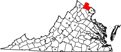
Unison, Virginia

Last updated

Unison, Virginia
USA Virginia Northern location map.svg
Red pog.svg
Unison
USA Virginia location map.svg
Red pog.svg
Unison
Usa edcp location map.svg
Red pog.svg
Unison
Coordinates: 39°2′6″N77°47′26″W / 39.03500°N 77.79056°W / 39.03500; -77.79056
CountryFlag of the United States.svg  United States
State Flag of Virginia.svg  Virginia
County Flag of Loudoun County, Virginia.svg Loudoun
Elevation
482 ft (147 m)
Time zone UTC−5 (Eastern (EST))
  Summer (DST) UTC−4 (EDT)
GNIS feature ID1477830 [1]

Unison is an unincorporated community village in Loudoun County, Virginia. [1] It is located approximately five miles from Middleburg in the Loudoun Valley close to the Fauquier County border.

Contents

History

Founded in about 1740 by Quakers who had migrated down from Pennsylvania, via Maryland and across the Potomac to the fertile farmlands of Northern Virginia, the village and its surrounds - later to become known as Union, and then Unison - was referred to as "Greenland" or "Butterland" in early 1800s deeds. The name "Butterland" was said to have come about as a nod to the Royal taxes at the time being collected in pounds of butter, rather than coin. [2]

In 1813 Virginia's General Assembly chartered the village as the Town of Union. That same year the federal government established the Union Post Office, discontinued twice in its early years, from 1820-1824, and in 1828. The post office was reestablished in 1829 under Union's new name of Unison which was forced on the town largely because Monroe Court House in Monroe County, Virginia had taken the name Union a few years prior, even though its own post office had been established 4 years after Loudoun's Union post office. Unfortunately for Loudoun's Union, Monroe County got preferred treatment because their courthouse was situated in their town of Union. [3]

By the 1830s Unison was the 4th largest town in Loudoun County. Yardley Taylor, writing for Joseph Martin's Gazetteer of Virginia in 1835, used the old name "Union" to identify Unison and counted 25 dwellings, 3 houses of worship, a school, 2 general stores, a blacksmith, and a tavern. Among the 135 inhabitants there were a number of professionals including a lawyer and 3 physicians. [3]

As the prospect of a civil war loomed on the horizon at the opening of the 1860s, the last vote of the Unison Precinct on May 23, 1861 - a count to affirm Virginia's secession from the Federal Union - was 150-0, the largest shutout vote for secession in the county. All the Quaker pacifists had remained home during the voting, so their voices against secession remained silent.

Between October 31 and November 2, 1862, the village was the scene of several skirmishes between Confederate cavalry under J.E.B. Stuart and Union cavalry, infantry and artillery in what is now known as the Battle of Unison. Because Stuart's delaying tactics at Unison cost the Federals time, a major portion of Lee's force had crossed the Blue Ridge, reached Culpeper and now had time to regroup and prepare for the next major encounter between the two sides at Fredericksburg. Lee's army and his capital were saved. On November 5, 1862, the New York Times correspondent reported "Stuart . . . balked what might have been a splendid success".

After the war Unison remained Loudoun County's 4th largest town for only a few more years. By the late 1870s towns along the railroad line running through western Loudoun County, which missed Unison by 8 miles, saw their populations boom, and soon outstripped Unison in both commercial and population importance. Unison's post office remained until 1919 when the mails were discontinued to the town, the post office was closed, and mail delivery moved to the post office in nearby town of Round Hill which was served by the Washington and Old Dominion Railroad. [3] However, even into the middle of the 20th century, Unison maintained itself as a viable town with its own churches, general store, and a saddle shop, and even a baseball team that played in the Loudoun baseball leagues. By the 1980s the town had been in decline, too far away from the new highways that now carried the bulk of Loudoun's commerce and population. By the 1990s the town had become little more than a sleepy residential enclave with only 50 permanent residences and 14 or so houses. The last retail enterprise, the Unison Store, a general store that had been in continuous business since 1880, closed in August 1996. [4]

In 2001 the vacant Unison Store building was being considered by a buyer as a tear down. This news prompted a local gathering of residents to attempt to save the building. They formed a 501[c]3 non-profit group, incorporated as "The Unison Preservation Society", their stated goal to help protect and preserve the historic village and surrounding countryside of Unison. As a result of their efforts Unison was placed on the Virginia Landmarks Register in 2002 as the Unison Historic District, and on the National Register of Historic Places in 2003. The store was purchased at highest bid by a local business at a public auction in 2001, and the building subsequently renovated. It was used as an office business until April 2013 when the building was again sold. It was purchased this time by a local philanthropist, Dr. Betsee Parker, owner of Huntlands, who then gifted the building to the Unison Preservation Society. [4] The old Unison Store is now a community center, serving the village and the surrounding area. [5]

On Sept. 22, 2011, due to the successful efforts of the Unison Preservation Society's research and documentation into the important historical significance of the battles and skirmishes that took place in and around the Unison area, Virginia added further buildings and acreage to the Virginia Landmarks register and nominated the 8,000-acre Unison Battlefield Historic District for inclusion on the National Register of Historic Places. [6]

The population count of Unison is now about 30, greatly outnumbered by the horses in the surrounding farms. The village contains a single United Methodist Church, and a number of private home businesses.

Related Research Articles

<span class="mw-page-title-main">Loudoun County, Virginia</span> County in Virginia, United States

Loudoun County is in the northern part of the Commonwealth of Virginia in the United States. In 2020, the census returned a population of 420,959, making it Virginia's third-most populous county. Loudoun County's seat is Leesburg. Loudoun County is part of the Washington–Arlington–Alexandria, DC–VA–MD–WV Metropolitan Statistical Area. As of 2020, Loudoun County had a median household income of $147,111. Since 2008, the county has been ranked first in the U.S. in median household income among jurisdictions with a population of 65,000 or more.

<span class="mw-page-title-main">Hamilton, Virginia</span> Town in Virginia

Hamilton is a town in the Loudoun Valley of Loudoun County, Virginia, United States. The population was 506 as of the 2010 census.

<span class="mw-page-title-main">Middleburg, Virginia</span> Town in Virginia

Middleburg is a town in Loudoun County, Virginia, United States, with a population of 673 as of the 2010 census. It is the southernmost town along Loudoun County's shared border with Fauquier County.

<span class="mw-page-title-main">Purcellville, Virginia</span> Small Town in Virginia

Purcellville is a town in Loudoun County, Virginia. The population was 8,929 according to the 2020 Census. Purcellville is the major population center for Western Loudoun and the Loudoun Valley. Many of the older structures remaining in Purcellville reflect the Victorian architecture popular during the early twentieth century.

<span class="mw-page-title-main">Point of Rocks, Maryland</span> Census-designated place in Maryland, United States

Point of Rocks is an unincorporated community and census-designated place (CDP) in Frederick County, Maryland. As of the 2010 census, it had a population of 1,466.

<span class="mw-page-title-main">Bluemont, Virginia</span> Unincorporated community in Virginia, United States

Bluemont is an unincorporated village in Loudoun County, Virginia located at the eastern base of Snickers Gap in the Blue Ridge Mountains. The village's center is located along Snickersville Turnpike, 4 miles (6.4 km) west of the incorporated town of Round Hill. The village borders Virginia's fox hunting country and is within 1 mile (1.6 km) of the Appalachian Trail and the Bears Den and Raven Rocks formations in the Blue Ridge.

<span class="mw-page-title-main">Waterford, Virginia</span> Unincorporated community in Virginia, United States

Waterford is an unincorporated village and census-designated place (CDP) in the Catoctin Valley of Loudoun County, Virginia, located along Catoctin Creek. Waterford is 47 miles (76 km) northwest of Washington, D.C., and 7 miles (11 km) northwest of Leesburg. The entire village and surrounding countryside is a National Historic Landmark District, noted for its well-preserved 18th and 19th-century character.

<span class="mw-page-title-main">Aldie, Virginia</span> Unincorporated community in Virginia, United States

Aldie is an unincorporated community and census-designated place (CDP) located between Chantilly and Middleburg in Loudoun County, Virginia, United States. The historic village of Aldie is located on the John Mosby Highway in a gap between the Catoctin Mountains and Bull Run Mountains, through which the Little River flows. Aldie traditionally serves as the gateway to the Loudoun Valley and beyond.

Taylorstown is a small community in Loudoun County, Virginia, built on the banks of Catoctin Creek and the surrounding hillside, about two miles (3 km) south of the Potomac River. First settled in 1734, it holds two of the oldest standing houses in Loudoun County, "Hunting Hill" and "Foxton Cottage", directly across the Catoctin Creek from each other.

<span class="mw-page-title-main">Fairlington, Arlington, Virginia</span> United States historic place

Fairlington is an unincorporated neighborhood in Arlington County, Virginia, United States, located adjacent to Shirlington in the southernmost part of the county on the boundary with the City of Alexandria. The main thoroughfares are Interstate 395 which divides the neighborhood into North and South Fairlington, State Route 7 and State Route 402.

<span class="mw-page-title-main">Loudoun Valley</span> Valley in northern Virginia

The Loudoun Valley is a small, but historically significant valley in the Blue Ridge Mountains located in Loudoun County in Northern Virginia in the United States.

Bloomfield is an unincorporated community in Loudoun County, Virginia. It is situated at the intersection of Airmont and Bloomfield Roads.

Loudoun County, Virginia, was destined to be an area of significant military activity during the American Civil War. Located on Virginia's northern frontier, the Potomac River, Loudoun County became a borderland after Virginia's secession from the Union in early 1861. Loudoun County's numerous Potomac bridges, ferries and fords made it an ideal location for the Union and Confederate armies to cross into and out of Virginia. Likewise, the county's several gaps in the Blue Ridge Mountains that connected the Piedmont to the Shenandoah Valley and Winchester were of considerable strategic importance. The opposing armies would traverse the county several times throughout the war leading to several small battles, most notably the Battle of Ball's Bluff.

<span class="mw-page-title-main">Battle of Unison</span> Battle of the American Civil War

The Battle of Unison or Battle of Union refers to a series of American Civil War cavalry skirmishes in Loudoun County, Virginia, between October 31 – November 2, 1862, between the Confederate forces of J.E.B. Stuart and various units of the Union Army of the Potomac. Although driven from the field in individual engagements, Stuart accomplished his mission to delay the enemy and screen the movements of the retreating Army of Northern Virginia.

Mountville is an unincorporated community in the Loudoun Valley of Loudoun County, Virginia. The village is situated on Snickersville Turnpike halfway between Aldie and Philomont at the intersection of Mountville Road.

<span class="mw-page-title-main">Ercildoun, Pennsylvania</span> United States historic place

Ercildoun, population about 100, is an unincorporated community in East Fallowfield Township, Chester County, Pennsylvania, United States. The hamlet was founded by Quakers and was an early center of the abolitionist movement. In 1985 the entire hamlet, including 31 properties, was listed as a historic district on the National Register of Historic Places. Of these properties two were vacant land, 14 were significant buildings, ten were contributing buildings, and five buildings, built in the 1950s, were non-contributing. The Lukens Pierce House, an octagon house listed separately on the U.S. National Register of Historic Places, is located about half a mile northwest of the hamlet. Ercildoun is one of about ten hamlets in the township, which has no cities or towns, but has 31 sites listed on the National Register. It is one of the larger hamlets, located near the center of the township, and historically among the best known. The city of Coatesville is about 3 miles north.

<span class="mw-page-title-main">Freeman Store and Museum (Vienna, Virginia)</span> Historic commercial building in Virginia, United States

The Freeman House Store, formerly the Lydecker Store, is a historic general store located in the Town of Vienna in Fairfax County, Virginia. The house lies in Northern Virginia near the District of Columbia. Built in 1859 for Abram Lydecker, both Confederate and Union Army troops occupied the house during the American Civil War. The house has been restored in accordance with historical records. Civil War paraphernalia are sold in a restored general store on the first floor of the house. A museum on the second floor of the house displays Civil War artifacts.

<span class="mw-page-title-main">Unison Historic District</span> Historic district in Virginia, United States

Unison Historic District is a national historic district located at Unison, near Middleburg, Loudoun County, Virginia. It encompasses 41 contributing buildings and 3 contributing structures in the village of Unison. It is primarily residential, but also includes a church, former school, store, and saddle-maker's shop. The oldest buildings are "Butterland" and "Elton." Other notable buildings include the Thornton Walker House, Mary Phillips House, Henry Evans House, Glatton Folly, and Unison United Methodist Church.

<span class="mw-page-title-main">Yardley Taylor</span>

Yardley Taylor was an American arborist and surveyor who was active in the abolition movement in Virginia.

References

  1. 1 2 "Unison". Geographic Names Information System . United States Geological Survey, United States Department of the Interior.
  2. Unison Preservation Society - History of Unison - website: unisonva.org/history.html
  3. 1 2 3 Eugene Scheel, Loudoun Times Mirror, "Unison Name Change Confused", published 10/8/1989
  4. 1 2 Linda Wheeler, Washington Post, "In Unison Lies Strength of History", published 12/8/2002
  5. "National Register Information System". National Register of Historic Places . National Park Service. July 9, 2010.
  6. "Archived copy" (PDF). Archived from the original (PDF) on January 26, 2017. Retrieved April 24, 2018.{{cite web}}: CS1 maint: archived copy as title (link)