
Waterford is a unique place of historic significance. The entire village and surrounding countryside is a National Historic Landmark District, noted for its well-preserved 18th and 19th-century character. It is an unincorporated village and census-designated place (CDP) in the Catoctin Valley of Loudoun County, Virginia, located along Catoctin Creek. Waterford is 47 miles (76 km) northwest of Washington, D.C., and 7 miles (11 km) northwest of Leesburg.
Taylorstown is a small community in Loudoun County, Virginia, built on the banks of Catoctin Creek and the surrounding hillside, about two miles (3 km) south of the Potomac River. First settled in 1734, it holds two of the oldest standing houses in Loudoun County, "Hunting Hill" and "Foxton Cottage", directly across the Catoctin Creek from each other.

Green Springs National Historic Landmark District is a national historic district in Louisa County, Virginia noted for its concentration of fine rural manor houses and related buildings in an intact agricultural landscape. The district comprises 14,000 acres (5,700 ha) of fertile land, contrasting with the more typical poor soil and scrub pinelands surrounding it.

The Glebe House, built in 1854–1857, is a historic house with an octagon-shaped wing in Arlington County, Virginia. The Northern Virginia Conservation Trust holds a conservation easement to help protect and preserve it. The name of the house comes from the property's history as a glebe, an area of land within an ecclesiastical parish used to support a parish priest. In this case, the glebe was established by the Church of England before the American Revolutionary War.

The South River Friends Meetinghouse, or Quaker Meeting House, is a historic Friends meeting house located at Lynchburg, Virginia. It was completed in 1798. It is a rubble stone structure, approximately 30 by 51 feet, with walls 16 inches thick, and 12 feet high. The building ceased as a Quaker meeting house in the 1840s and stands on the grounds of the Quaker Memorial Presbyterian Church. Adjacent to the structure is a historic graveyard. Buried there are Sarah Lynch and her son John, the founder of the city whose final resting place is marked by a plain Quaker stone and a modern plaque.

This is a list of the National Register of Historic Places listings in Henrico County, Virginia.

This is a list of the National Register of Historic Places listings in Loudoun County, Virginia.

Glebe Church is a historic Anglican church in Driver, Virginia and its surrounding glebe. The church was built in 1737–1738, and is a rectangular, gable-roofed, brick church measuring 48 feet, 6 inches, by 25 feet, 4 inches. It was added to the National Register of Historic Places in 1973.

St. John's Church, also known as Chuckatuck Church is a historic Episcopal church located near Chuckatuck. Constructed in 1755, St. John's is the third church to occupy the site in a parish which was established in 1642. St. John's Church preserves an important role in the religious history of seventeenth century Virginia and as an architectural example of the evolving preferences of the Episcopal Church in the nineteenth century.

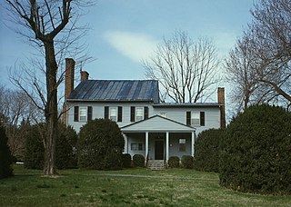
The Glebe of Shelburne Parish is a house built as a glebe in rural Loudoun County, Virginia around 1775 to attract a cleric to preach in the Shelburne Parish of the Anglican Church. Shelburne Parish, named for the Earls of Shelburne, desired in 1771 that a minister preach at Leesburg, Virginia every three months. The absence of a glebe and glebe lands detracted from efforts to recruit a parson, so in 1773 the parish purchased 473 acres (191 ha) and built a house on the property.

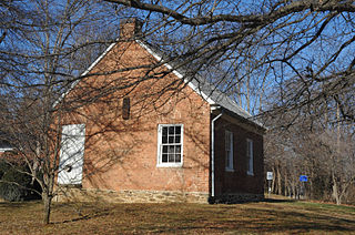
The Goose Creek Meeting House Complex is a Quaker worship center, with an original 1765 Meeting House, an 1817 meeting house, a burying ground, and the Oakdale schoolhouse in the village of Lincoln, Virginia. The complex is on the site of the original log meeting house, built about 1750. The 1765 meeting house is a one-story stone building, and was converted to a residence after the construction of the 1817 meeting house.
The Goose Creek Historic District is a rural landscape in the Goose Creek valley of Loudoun County, Virginia. The district covers about 10,000 acres (4,000 ha) south of Hamilton and Purcellville and includes the village of Lincoln. The majority of the district is farmland, with areas of forest along Hogback Mountain. The area was settled by Quakers in the mid-18th century, represented by simple houses and the Goose Creek Meetinghouse Complex in Lincoln, separately listed on the National Register of Historic Places. About 270 buildings lie within the district. The district includes 44 stone buildings, reflecting the popularity of this material in the 18th and 19th centuries in this area. Many houses have outbuildings and barns built in a manner complementary to the dwellings. By the mid-19th century, materials turned to brick, with the Glebe of Shelburne Parish an NRHP-listed example of a brick Federal style house, as well as the Israel Janney House.

The Goose Creek Stone Bridge crosses Goose Creek in Loudoun County, Virginia. The 200-foot (61 m) long stone arch bridge spans the creek in four arches. Built about 1810, it is the largest stone turnpike bridge in northern Virginia, designed to carry the Ashby's Gap Turnpike across the creek. The turnpike was replaced by U.S. Route 50, which crosses the creek a short distance to the south. The bridge is no longer used for vehicular traffic. The bridge was a center of fighting in the American Civil War on June 21, 1863, during the Battle of Upperville.
Boswell's Tavern is an excellent example of a complete 18th century tavern in Virginia. Located near Gordonsville, Virginia, the tavern is located at the intersection of present-day U.S. Route 15 and Virginia State Route 22, the centerpiece of a village named after the tavern. The tavern was built in the mid-18th century, probably by Colonel John Boswell. The tavern was the site of a 1781 encampment by American forces during the American Revolutionary War under the Marquis de Lafayette. The tavern was a frequent meeting place for notable Virginia figures, including Thomas Jefferson, James Madison and Patrick Henry. A few colonial troops were captured at the tavern in March 1781 by British colonel Banastre Tarleton in an attempt to capture Jefferson and to disrupt meetings of the Virginia legislature.

Abingdon Church is a historic Episcopal church located near White Marsh, Gloucester County, Virginia. It and its glebe house are among the oldest buildings in Virginia and were added to the National Register of Historic Places in 1970.

Abingdon Glebe House is a historic home located near Gloucester, Gloucester County, Virginia. It was built around 1700, and is T-shaped brick structure with one-story hipped roof end pavilions flanking the central portion of the house. The central portion and rear ell are topped by steep gable roofs. It was extensively renovated about 1954. The house and surrounding glebe lands were owned by Abingdon Parish until they were confiscated by legislative act in 1802 as part of the Disestablishment. It was acquired by William Riddick of Gloucester in the 1980s, and was bequeathed to St. James On-the-Glebe Anglican Church, a parish of the Anglican Province of America, after Riddick's death in 2006.

Glebe of Westover Parish is a historic home located near Ruthville, Charles City County, Virginia. It built about 1745, as a 1+1⁄2-story, five-bay brick building, with an early 19th-century rear ell. It reflects Colonial and Federal style design elements. It also has an early 20th-century, one-story, frame wing. It was built as a glebe house for Westover Parish. The house was sold into private hands after the 1807 act of the General Assembly requiring the sale of all Virginia glebes.

Glebe House of St. Anne's Parish is a historic Episcopal glebe house located near Champlain, Essex County, Virginia. It was built about 1730, and is a two-story, three-bay, brick building with a gable roof. It measures about 50 feet long by 20 feet wide and features interior end chimneys.

Glebe of Hungar's Parish is a historic glebe house located at Franktown, Northampton County, Virginia. It was built sometime between 1643 and 1745, and is a 1 1/2-story, brick, structure with gable roof, dormers, and two interior end chimneys. It was the official residence of the ministers of Hungar's Parish from 1745 until 1850. The Glebe is not actually in Franktown but about 10 miles southwest on the shores of Chesapeake Bay.

Glebe House of Southwark Parish, also known as The Old Glebe, is a historic glebe house located near Spring Grove, Surry County, Virginia. It was built about 1724, and is a 1+1⁄2-story, three-bay, single pile, central-hall plan brick dwelling. It has a gambrel roof with dormers, added in the 19th century, has exterior end chimneys, and sits on a brick basement. Also on the property is a contributing frame smokehouse. The glebe house was sold, as required by the legislature during the Disestablishment of 1802. It was subsequently remodeled and used as a private dwelling.It sits on the site of Indian Spring Plantation patented by Nicholas Merriweather in 1666. The property is currently owned by the Perkins family.


