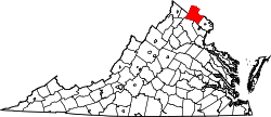
Saint Louis, Virginia | |
---|---|
Coordinates: 39°00′14″N77°47′25″W / 39.003965°N 77.790176°W | |
Country | United States |
State | Virginia |
County | Loudoun |
Time zone | UTC−5 (Eastern (EST)) |
• Summer (DST) | UTC−4 (EDT) |
Saint Louis is an unincorporated community in southwestern Loudoun County, Virginia. Saint Louis is located near the intersection of Saint Louis Road (Virginia State Route 611) and Snake Hill Road (Virginia State Route 744), six miles west of Middleburg. It is a historic African American community dating from 1891 or earlier, with many African Americans still living there today. Banneker Elementary School is located in Saint Louis. [1]
.... the school board decided to purchase 19 acres of land in St. Louis, which is located six miles west of Middleburg. A fireproof building consisting of six classrooms, a multi-purpose room, a clinic, and a kitchen, was built on this property. On March 31, 1948, the children and faculty of the Middleburg, St. Louis, and Mountville schools, with an approximate enrollment of 185 students, entered the beautiful brick building for the first time. .... The school was named for the famous Benjamin Banneker who constructed the first clock made entirely in America in 1753, and who was part of the surveying team who laid out the city of Washington, DC, in 1791.Archived November 27, 2020, at the Wayback Machine .
A six room school was built in 1948, and named after Benjamin Banneker, a famous African American scientist, inventor, surveyor & anti slavery publicist.Archived January 3, 2021, at the Wayback Machine .
Five years ago, Banneker was designated the home school for Middleburg, when Middleburg Elementary became a charter school.
Loudoun County is in the northern part of the Commonwealth of Virginia in the United States. In 2020, the census returned a population of 420,959, making it Virginia's third-most populous county. Loudoun County's seat is Leesburg. Loudoun County is part of the Washington–Arlington–Alexandria, DC–VA–MD–WV Metropolitan Statistical Area. As of 2020, Loudoun County had a median household income of $147,111. Since 2008, the county has been ranked first in the U.S. in median household income among jurisdictions with a population of 65,000 or more.
Catonsville is a census-designated place (CDP) in Baltimore County, Maryland. The population was 41,567 at the 2010 census. The community lies to the west of Baltimore along the city's border. Catonsville contains the majority of the University of Maryland, Baltimore County (UMBC), a major public research university with close to 14,000 students.
Ellisville is a city in St. Louis County, Missouri, United States within Greater St. Louis. It is a western outer-ring suburb of St. Louis. The population was 9,985 at the 2020 census.
Centreville is a census-designated place (CDP) in Fairfax County, Virginia, United States and a suburb of Washington, D.C. The population was 73,518 as of the 2020 census. Centreville is approximately 20 miles (32 km) west of Washington, D.C.
Chantilly is a census-designated place (CDP) in western Fairfax County, Virginia. The population was 24,301 as of the 2020 census. Chantilly is named after an early-19th-century mansion and farm, which in turn took the name of an 18th-century plantation that was located in Westmoreland County, Virginia. The name "Chantilly" originated in France with the Château de Chantilly, about 28 miles north of Paris.
Leesburg is a town in and the county seat of Loudoun County, Virginia, United States. Settlement in the area began around 1740, which is named for the Lee family, early leaders of the town. Located in the far northeast of the state, in the War of 1812 it was a refuge for important federal documents evacuated from Washington, DC, and in the Civil War, it changed hands several times.
Middleburg is a town in Loudoun County, Virginia, United States, with a population of 673 as of the 2010 census. It is the southernmost town along Loudoun County's shared border with Fauquier County.
Purcellville is a town in Loudoun County, Virginia. The population was 8,929 according to the 2020 Census. Purcellville is the major population center for Western Loudoun and the Loudoun Valley. Many of the older structures remaining in Purcellville reflect the Victorian architecture popular during the early twentieth century.
Round Hill is a town in Loudoun County, Virginia, United States. Its population was 539 at the 2010 census and an estimated 656 in 2019. The town is located at the crossroads of Virginia Routes 7 and 719, approximately 50 miles (80 km) northwest of Washington, D.C. The town's name refers a hill two miles northeast of a 910-foot (280 m) hill used during the American Civil War as a signal post by both Confederate and Union troops. House of Round Hill was built in 2004. Patsy Cline went to Round Hill Elementary School.
Sterling, Virginia, refers most specifically to a census-designated place (CDP) in Loudoun County, Virginia, United States. The population of the CDP as of the 2010 United States Census was 27,822. The CDP boundaries are confined to a relatively small area between Virginia State Route 28 on the west and Virginia State Route 7 on the northeast, excluding areas near SR 606 and the Dulles Town Center.
Ashburn is a census-designated place (CDP) in Loudoun County, Virginia, United States. At the 2010 United States Census, its population was 43,511, up from 3,393 twenty years earlier. It is 30 miles (48 km) northwest of Washington, D.C., and part of the Washington metropolitan area.
South Riding is a census-designated place and planned community in Loudoun County, Virginia, United States. The South Riding homeowner association was founded in January 1995 to provide services to the community. Neighboring U.S. Route 50 and State Route 28 provide access to the Dulles/Reston/Tysons Corner technology corridor and other major employment centers in Northern Virginia and Washington, D.C.
Bluemont is an unincorporated village in Loudoun County, Virginia located at the eastern base of Snickers Gap in the Blue Ridge Mountains. The village's center is located along Snickersville Turnpike, 4 miles (6.4 km) west of the incorporated town of Round Hill. The village borders Virginia's fox hunting country and is within 1 mile (1.6 km) of the Appalachian Trail and the Bears Den and Raven Rocks formations in the Blue Ridge.
Aldie is an unincorporated community and census-designated place (CDP) located between Chantilly and Middleburg in Loudoun County, Virginia, United States. The historic village of Aldie is located on the John Mosby Highway in a gap between the Catoctin Mountains and Bull Run Mountains, through which the Little River flows. Aldie traditionally serves as the gateway to the Loudoun Valley and beyond.
Loudoun County Public Schools (LCPS) is a branch of the Loudoun County, Virginia, United States government, and administers public schools in the county. LCPS's headquarters is located at 21000 Education Court in Ashburn, an unincorporated section of the county.
Stone Ridge is a census-designated place in Loudoun County, Virginia, United States. Residences use Aldie mailing addresses, and it is near Washington Dulles International Airport. The population as of the 2020 census was 15,039. Stone Ridge is a Van Metre Homes planned, mixed-use community.
Dover is an unincorporated community in Loudoun County, Virginia, United States. Dover is located east of Middleburg at the intersection of U.S. Route 50, Champe Ford Road, and Cobb House Road. The Little River begins following Route 50 at this point.
Benjamin Banneker: SW 9 Intermediate Boundary Stone, also known as an Intermediate Stone of the District of Columbia, is a surveyors' boundary marker stone. The stone is located on the original boundary of the District of Columbia The stone is now on the boundary of Arlington County, Virginia and the City of Falls Church. It is within the two jurisdiction's Benjamin Banneker Park at 6620 18th Street North, Arlington.
According to accounts that began to appear during the 1960s or earlier, a substantial mythology has exaggerated the accomplishments of Benjamin Banneker (1731–1806), an African-American naturalist, mathematician, astronomer and almanac author who also worked as a surveyor and farmer.
A United States postage stamp and the names of a number of recreational and cultural facilities, schools, streets and other facilities and institutions throughout the United States have commemorated Benjamin Banneker's documented and mythical accomplishments throughout the years since he lived (1731–1806). Among such memorializations of this free African American almanac author, surveyor, landowner and farmer who had knowledge of mathematics, astronomy and natural history was a biographical verse that Rita Dove, a future Poet Laureate of the United States, wrote in 1983 while on the faculty of Arizona State University.