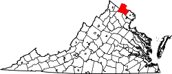
Telegraph Spring, Virginia | |
---|---|
Coordinates: 39°6′18″N77°42′30″W / 39.10500°N 77.70833°W | |
Country | United States |
State | Virginia |
County | Loudoun |
Time zone | UTC−5 (Eastern (EST)) |
• Summer (DST) | UTC−4 (EDT) |
Telegraph Spring is an unincorporated community in Loudoun County, Virginia. Telegraph Spring lies to the south of Hamilton.
Telegraph Spring is named for a naturally occurring spring that still flows today. A small metal pipe protrudes from the east side of Telegraph Springs Road (Route 611) just south of the intersection with Chappelle Hill Road. The water that flows continuously from the pipe is the spring. During the 2007 drought the spring has ceased to flow.
Telegraph Springs Road runs from Purcellville to Philomont. It is also known as State Route 611 and is paved for approximately half the length with the southern half gravel and dirt.
Horsham is a census place in Horsham Township, Montgomery County, Pennsylvania, United States. The population was 15,193 at the 2020 census. It is home to the Horsham Air Guard Station at the former site of Naval Air Station Joint Reserve Base Willow Grove.
The Mill Creek is a stream in southwest Ohio. It flows 28.4 miles (45.7 km) southwest and south from its headwaters in Liberty Township of Butler County through central Hamilton County and the heart of Cincinnati into the Ohio River just west of downtown. The section of Interstate 75 through Cincinnati is known as the Mill Creek Expressway.
State Route 241 is a primary state highway in the U.S. state of Virginia. The state highway runs 1.88 miles (3.03 km) from U.S. Route 1 in Huntington north to SR 236 in Alexandria. SR 241 connects US 1 and SR 236, bypass Old Town Alexandria to the southwest. The state highway connects those highways with Interstate 95 and I-495, Huntington Avenue, and Eisenhower Avenue in a series of interchanges along the boundary of Fairfax County and the independent city of Alexandria. SR 241 also connects the above highways to the Huntington station of the Washington Metro, for which the portion of the highway from US 1 to the station is part of the National Highway System.
A continuous flow intersection (CFI), also called a crossover displaced left-turn, is an alternative design for an at-grade road junction. Vehicles attempting to turn across the opposing direction of traffic cross before they enter the intersection. No left turn signal in the intersection is then necessary. Instead, vehicles traveling in both directions can proceed, including through vehicles and those turning right or left, when a generic traffic signal/stop sign permits.
Pennsylvania Route 611 is a state highway in eastern Pennsylvania running 109.7 mi (176.5 km) from Interstate 95 (I-95) in the southern part of the city of Philadelphia north to I-380 in Coolbaugh Township in the Pocono Mountains. Through most of Philadelphia, PA 611 follows Broad Street, the main north-south street in the city. The route continues north through the northern suburbs of Philadelphia and serves Jenkintown, Willow Grove, and Doylestown, the latter of which it bypasses on a freeway. North of Doylestown, PA 611 heads through rural areas and runs along the west bank of the Delaware River to the city of Easton in the Lehigh Valley. The route continues back into rural land and passes through the Delaware Water Gap, at which point it enters the Pocono Mountains region. Here, PA 611 heads northwest through Stroudsburg and Mount Pocono toward its northern terminus.
Pipe Mania is a puzzle video game developed by The Assembly Line for the Amiga and published in 1989. It was ported to several other platforms by Lucasfilm Games as Pipe Dream; the company distributed the game in the US. The player must connect randomly appearing pieces of pipe on a grid to a given length within a limited time.
Fallen Leaf Lake is a mountain lake located in El Dorado County, California, near the California–Nevada state border, about one mile south west of the much larger Lake Tahoe. It is approximately aligned north-to-south and oval in shape, measuring approximately 2.9 miles (4.6 km) on the long axis and 0.9 miles (1.4 km) on the short axis. The lake was created by at least two glaciers that traveled northward down the Glen Alpine Valley. If the glacier had continued instead of stopping, Fallen Leaf Lake would be a bay of Lake Tahoe, similar to nearby Emerald Bay. A terminal moraine is visible at the north end of the lake on the northeast edge.
State Route 613 in Fairfax County, Virginia is a secondary state highway. The designation includes several distinct suburban surface routes within the county. These routes were once mostly connected, but changes in road alignment, new road construction, and annexations by the independent city of Alexandria have separated them. These routes are signed only sporadically as 613 and local residents usually refer to these routes by their names.
Louisiana Highway 611 is a collection of three current and ten former state-maintained streets in Jefferson, Metairie, and New Orleans. All thirteen routes were established with the 1955 Louisiana Highway renumbering.
Pennsylvania Route 413 is a 31-mile-long (50 km), north–south state highway in Bucks County, Pennsylvania. The route runs from the New Jersey state line on the Burlington–Bristol Bridge over the Delaware River outside Bristol, where the road continues as Route 413 into New Jersey, north to PA 611 in Bedminster Township. The route passes through the lower and central portions of Bucks County, serving Bristol, Levittown, Langhorne, Newtown, and Buckingham. The route intersects U.S. Route 13 and Interstate 95 (I-95) near Bristol, I-295 near Penndel, US 1 in Langhorne Manor, and US 202 in Buckingham.
In 1955, Louisiana passed a law that undertook a comprehensive revision to the state highway classification and numbering system. The new system designated roads by importance to travel patterns and rectified the previous numbering system under new unified designations.
Pennsylvania Route 690 (PA 690) is a 12.53-mile-long (20.17 km) state highway located in Lackawanna and Wayne counties in Pennsylvania. The western terminus is at PA 502 in Spring Brook Township. The eastern terminus is at PA 590 in Salem Township. The route is a two-lane undivided road running through rural and some developed areas southeast of Scranton. From the western terminus, the route crosses PA 307 and has a partial interchange with Interstate 380 (I-380) before reaching Moscow, where it forms a brief concurrency with PA 435. From Moscow, PA 690 continues northeast to its terminus at PA 590 in Hollisterville. PA 690 was designated in 1928 between U.S. Route 611 in Moscow and PA 590 in Hollisterville. The route was extended west to PA 502 in the 1930s.
Kuttolsheim is a commune in the Bas-Rhin department in Grand Est in north-eastern France.
A wind instrument is a musical instrument that contains some type of resonator in which a column of air is set into vibration by the player blowing into a mouthpiece set at or near the end of the resonator. The pitch of the vibration is determined by the length of the tube and by manual modifications of the effective length of the vibrating column of air. In the case of some wind instruments, sound is produced by blowing through a reed; others require buzzing into a metal mouthpiece, while yet others require the player to blow into a hole at an edge, which splits the air column and creates the sound.
The South Negril River is a river in Westmoreland, Jamaica.
State Route 611 in Fairfax County, Virginia is a secondary state highway which traverses the eastern portion of the county. SR 611 provides a major artery for commuters, connecting the Eisenhower Valley section of Alexandria with Lorton and points south along US 1. SR 611 is known by three names: Telegraph Road, Old Colchester Road, and Furnace Road.
The Petersham Hole was a sink hole caused by subsidence of a sewer which forced the total closure of the A307 road in Petersham in the London Borough of Richmond upon Thames in 1979–80. It caused long-term disruption to traffic in the surrounding area and significant direct and indirect costs.
The Eckbach is a small river in the northeastern Palatinate and the southeastern Rhenish Hesse. It is slightly over 39 kilometres (24 mi) long.
The Verkeerder Kill, sometimes Verkeerderkill and locally shortened to Kaidy Kill is an 8-mile-long (13 km) stream in Ulster County, New York, United States. It rises on the Shawangunk Ridge, in the town of Wawarsing, and flows southwards through the town of Shawangunk, toward the Shawangunk Kill, itself a major tributary of the Wallkill River. Ultimately it is a part of the Hudson River's watershed.