Georges Mill, Virginia

Last updated

Georges Mill, Virginia
USA Virginia Northern location map.svg
Red pog.svg
Georges
Mill
USA Virginia location map.svg
Red pog.svg
Georges
Mill
Usa edcp location map.svg
Red pog.svg
Georges
Mill
Coordinates: 39°17′16″N77°39′46″W / 39.28778°N 77.66278°W / 39.28778; -77.66278
CountryFlag of the United States.svg  United States
State Flag of Virginia.svg  Virginia
County Flag of Loudoun County, Virginia.svg Loudoun
Time zone UTC−5 (Eastern (EST))
  Summer (DST) UTC−4 (EDT)

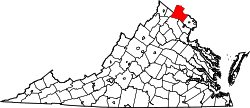
Georges Mill is an unincorporated village in northern Loudoun County, Virginia. The community takes its name from the mill that once operated there on Dutchman Creek to the north of Elvan. Georges Mill is located at the crossroads of Irish Corner Road (VA 673) and Georges Mill Road (VA 852).


Related Research Articles

<span class="mw-page-title-main">Roanoke, Virginia</span> Independent city in Virginia, United States

Roanoke is an independent city in the U.S. state of Virginia. It is located in Southwest Virginia along the Roanoke River, in the Blue Ridge range of the greater Appalachian Mountains, approximately 50 miles (80 km) north of the Virginia–North Carolina border and 250 miles (400 km) southwest of Washington, D.C., along Interstate 81. At the 2020 census, Roanoke's population was 100,011, making it the largest city in Virginia west of the state capital Richmond. It is the principal municipality of the Roanoke metropolitan area, which had a 2020 population of 315,251.

<span class="mw-page-title-main">Prince George County, Virginia</span> County in Virginia, United States

Prince George County is a county located in the Commonwealth of Virginia. As of the 2020 census, the population was 43,010. Its county seat is Prince George.

<span class="mw-page-title-main">Springfield, Virginia</span> Census-designated place in Virginia, United States

Springfield is a census-designated place (CDP) in Fairfax County, Virginia, United States. The Springfield CDP is recognized by the U.S. Census Bureau with a population of 30,484 as of the 2010 census. Homes and businesses in bordering CDPs including North Springfield, West Springfield, and Newington are usually given a Springfield mailing address. The population of the collective areas with Springfield addresses is estimated to exceed 100,000. The CDP is a part of Northern Virginia, the most populous region of the Washington Metropolitan Area.

<span class="mw-page-title-main">Shenandoah River</span> River in Virginia and West Virginia, United States

The Shenandoah River is the principal tributary of the Potomac River, 55.6 miles (89.5 km) long with two forks approximately 100 miles (160 km) long each, in the U.S. states of Virginia and West Virginia. The river and its tributaries drain the central and lower Shenandoah Valley and the Page Valley in the Appalachians on the west side of the Blue Ridge Mountains, in northwestern Virginia and the Eastern Panhandle of West Virginia. There is a hydroelectric plant along the Shenandoah river constructed in 2014 by Dominion.

<span class="mw-page-title-main">Virginia State Route 620 (Fairfax and Loudoun Counties)</span> Highway in Virginia

State Route 620 in Fairfax and Loudoun Counties, Virginia is a secondary state highway. The entire length of SR 620 is also known as Braddock Road. SR 620 also has a short concurrency with SR 659 / Union Mill Road in Centreville.

<span class="mw-page-title-main">Colonial Parkway</span> Scenic parkway in Virginia

Colonial Parkway is a 23-mile (37 km) scenic parkway linking the three points of Virginia's Historic Triangle, Jamestown, Williamsburg, and Yorktown. It is part of the National Park Service's Colonial National Historical Park. Virginia's official state classification for the parkway is State Route 90003. With portions built between 1930 and 1957, it links the three communities via a roadway shielded from views of commercial development. The roadway is toll-free, is free of semi trucks, and has speed limits of around 35 to 45 mph. As a National Scenic Byway and All-American Road, it is also popular with tourists due to the James River and York River ends of the parkway.

<span class="mw-page-title-main">George Washington Memorial Parkway</span> 7,142-acre parkway maintained by the National Park Service

The George Washington Memorial Parkway, colloquially the G.W. Parkway, is a 25-mile-long (40 km) parkway that runs along the south bank of the Potomac River from Mount Vernon, Virginia, northwest to McLean, Virginia, and is maintained by the National Park Service (NPS). It is located almost entirely within Virginia, except for a short portion of the parkway northwest of the Arlington Memorial Bridge that passes over Columbia Island within the District of Columbia.

<span class="mw-page-title-main">James River and Kanawha Canal</span> United States historic place

The James River and Kanawha Canal was a partially built canal in Virginia intended to facilitate shipments of passengers and freight by water between the western counties of Virginia and the coast. Ultimately its towpath became the roadbed for a rail line following the same course.

<span class="mw-page-title-main">Richmond Main Street Station</span> Railway station in Richmond VA

Richmond Main Street Station, officially the Main Street Station and Trainshed, is a historic railroad station and office building in Richmond, Virginia. It was built in 1901, and is served by Amtrak. It is also an intermodal station with Richmond's city transit bus services, which are performed by Greater Richmond Transit Company (GRTC). It is colloquially known by people from the city as The Clock Tower. It is a U.S. National Historic Landmark. Main Street Station serves as a secondary train station for Richmond providing limited Amtrak service directly to downtown Richmond. Several Amtrak trains serving the Richmond metropolitan area only stop at the area's primary rail station, Staples Mill Road which is located five miles to the north in Henrico County.

<span class="mw-page-title-main">Brucetown, Virginia</span> Unincorporated community in Virginia, United States

Brucetown is an unincorporated community and census-designated place (CDP) in northern Frederick County, Virginia, United States. It was first listed as a CDP in the 2020 census with a population of 274. Brucetown lies at the intersection of Brucetown and Sir John Roads. A post office was established in the community in 1819. Brucetown also had its own school in operation from 1871 to 1941.

<span class="mw-page-title-main">Virginia State Route 45</span>

State Route 45 is a primary state highway in the U.S. state of Virginia. The state highway runs 39.72 miles (63.92 km) from the junction of U.S. Route 15 Business and US 460 Business in Farmville north to SR 6 at Georges Tavern. SR 45 is the primary north–south highway of Cumberland County, where the highway meets US 60 near the county seat, Cumberland.

<span class="mw-page-title-main">Virginia State Route 204</span>

State Route 204 is a primary state highway in the U.S. state of Virginia. Known as Popes Creek Road, the state highway runs 1.73 miles (2.78 km) from SR 3 near Potomac Mills east to George Washington Birthplace National Monument in northwestern Westmoreland County.

<span class="mw-page-title-main">Virginia State Route 206</span>

State Route 206 is a primary state highway in the U.S. state of Virginia. Known as Dahlgren Road, the state highway runs 11.04 miles (17.77 km) from SR 3 at Arnolds Corner east to SR 604 at the entrance to the Naval Surface Warfare Center Dahlgren Division in Dahlgren in eastern King George County.

<span class="mw-page-title-main">Virginia State Route 235</span>

State Route 235 is a primary state highway in the U.S. state of Virginia. The state highway runs 5.05 miles (8.13 km) between intersections with U.S. Route 1 in Fort Belvoir and Hybla Valley. SR 235 forms a southeast loop off of US 1 through the community of Mount Vernon in southeastern Fairfax County, connecting US 1 with Mount Vernon, the plantation home of George Washington, and the southern end of the George Washington Memorial Parkway.

<span class="mw-page-title-main">Virginia State Route 253</span> State highway in Virginia, United States

State Route 253 is a primary state highway in the U.S. state of Virginia. Known as Port Republic Road, the state highway runs 12.18 miles (19.60 km) from U.S. Route 11 in Harrisonburg east to US 340 near Port Republic. SR 253 is a northwest–southeast highway that connects Harrisonburg with Cross Keys and Port Republic in southeastern Rockingham County. The state highway also provides access to portions of James Madison University on either side of Interstate 81 (I-81). SR 253 is maintained by the Virginia Department of Transportation except for the portion in the independent city of Harrisonburg, which is municipally maintained.

<span class="mw-page-title-main">Clarke's Gap</span>

Clarke's Gap, also known as Clarks Gap, is a pass through Catoctin Mountain west of Leesburg, Virginia. The gap has an elevation of 643 feet (196 m). The gap is not a true wind gap, but rather a man-made railroad cut through a local saddle point between two ridges to the southeast and northwest created by the drainage of Dry Mill Branch of Tuscarora Creek to the east and an unnamed tributary of Catoctin Creek to the west.

Hope Park was an 18th and 19th-century plantation in Fairfax County in the U.S. state of Virginia, where Dr. David Stuart (1753–1814), an old friend of and correspondent with George Washington lived with his wife, Eleanor Calvert Custis (1758–1811), and family. It was approximately 5 miles (8.0 km) southwest of Fairfax Court House.

<span class="mw-page-title-main">1965 Virginia gubernatorial election</span> Election for the governorship of the U.S. state of Virginia

In the 1965 Virginia gubernatorial election, incumbent Governor Albertis Harrison, a Democrat, was unable to seek re-election due to term limits. Linwood Holton, an attorney from Roanoke, was nominated by the Republican Party to run against Democratic Lieutenant Governor of Virginia Mills Godwin.

Lake Matoaka is a mill pond on the campus of the College of William & Mary in Williamsburg, Virginia, located in the College Woods. Originally known both as Rich Neck Pond for the surrounding Rich Neck Plantation and Ludwell's Mill Pond for Philip Ludwell who owned it, Lake Matoaka was constructed around 1700 to power a gristmill. The pond was renamed after acquisition by the college to bear the Powhatan name for Pocahontas. Construction projects by the Civilian Conservation Corps, college, and others have contributed to the lake becoming a site for outdoor entertainment and recreation.