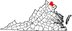
Goose Creek Village, Virginia

Last updated
Goose Creek Village, Virginia
USA Virginia Northern location map.svg
Red pog.svg
Goose Creek Village
USA Virginia location map.svg
Red pog.svg
Goose Creek Village
Usa edcp location map.svg
Red pog.svg
Goose Creek Village
Coordinates: 39°2′40″N77°31′21″W / 39.04444°N 77.52250°W / 39.04444; -77.52250 Coordinates: 39°2′40″N77°31′21″W / 39.04444°N 77.52250°W / 39.04444; -77.52250
Country United States
State Virginia
County Loudoun
Area
[1]
  Total0.38 sq mi (0.98 km2)
  Land0.38 sq mi (0.98 km2)
  Water0.0 sq mi (0.0 km2)
Elevation
405 ft (123 m)
Time zone UTC−5 (Eastern (EST))
  Summer (DST) UTC−4 (EDT)
FIPS code 51-31912
GNIS feature ID2804163

Goose Creek Village is a census-designated place (CDP) in Loudoun County, Virginia, United States. It was first drawn as a CDP prior to the 2020 census.

Geography

Goose Creek Village is east of the center of Loudoun County, on the west side of Belmont Ridge Road. The Dulles Greenway (Virginia Route 267) runs through the southern part of the CDP, leading northwest 7 miles (11 km) to Leesburg, the county seat, and southeast 10 miles (16 km) to Washington Dulles International Airport. The community is bordered to the east by Ashburn.

According to the U.S. Census Bureau, the Goose Creek Village CDP has a total area of 0.38 square miles (0.98 km2), all land. [1] The community sits on the west side of a ridge above Goose Creek, a north-flowing tributary of the Potomac River.

Related Research Articles

Chantilly, Virginia CDP in Virginia, United States

Chantilly is a census-designated place (CDP) in western Fairfax County, Virginia, United States. The population was 23,039 at the 2010 census. Chantilly is named after an early-19th-century mansion and farm, which in turn took the name of an 18th-century plantation that was located in Westmoreland County, Virginia. The name "Chantilly" originated in France with the Château de Chantilly, about 28 miles north of Paris.

Rose Hill, Lee County, Virginia Census-designated place in Virginia, United States

Rose Hill is an unincorporated community and census-designated place (CDP) in Lee County, Virginia, United States. The population was 799 at the 2010 census, up from 714 at the 2000 census.

Hillsboro, Loudoun County, Virginia Town in Virginia

Hillsboro is a rural town in Loudoun County, Virginia, United States. The population was 80 at the 2010 census and an estimated 169 as of 2019.

Leesburg, Virginia Town in Virginia

Leesburg is the county seat of Loudoun County, Virginia. It was built in 1740 and is named for the Lee family, early leaders of the town and ancestors of Robert E. Lee. In the War of 1812, it became the temporary seat of the United States government, and in the Civil War, it changed hands several times.

Lovettsville, Virginia Town in Virginia

Lovettsville is a town in Loudoun County, located near the very northern tip of the Commonwealth of Virginia, United States. Settled primarily by German immigrants, the town was originally established in 1836.

Round Hill, Loudoun County, Virginia Town in Virginia

Round Hill is a town in Loudoun County, Virginia, United States. Its population was 539 at the 2010 census and an estimated 656 in 2019. The town is located at the crossroads of Virginia routes 7 and 719, approximately 50 miles (80 km) northwest of Washington, D.C. It was named "Round Hill" for being two miles northeast of a 910-foot (280 m) hill used during the American Civil War as a signal post by both Confederate and Union troops.

Leola, Pennsylvania Census-designated place in Pennsylvania, United States

Leola is a census-designated place (CDP) in Lancaster County, Pennsylvania, United States. It includes the unincorporated communities of Leola, Leacock, and Bareville, and prior to 2010 was known as the Leacock-Leola-Bareville census-designated place. Originally named "Mechanicsburg", its present name is a portmanteau of "Leacock" and the "Glenola" train station that once served the town. As of the 2010 census, the population of the CDP was 7,214.

Ashburn, Virginia Census-designated place in Virginia

Ashburn is a census-designated place (CDP) in Loudoun County, Virginia, United States. As of the 2010 United States Census, its population was 43,511, up from 3,393 twenty years earlier. It is 30 miles (48 km) northwest of Washington, D.C., and part of the Washington metropolitan area.

South Riding, Virginia Census-designated place in Virginia

South Riding is a census-designated place and planned community in Loudoun County, Virginia. South Riding was founded as a homeowner association in January 1995 to provide services to the community. Neighboring U.S. Route 50 and State Route 28 provide access to the Dulles/Reston/Tysons Corner technology corridor and other major employment centers in Northern Virginia and Washington, D.C.

New Tripoli, Pennsylvania Census-designated place in Pennsylvania, United States

New Tripoli is an unincorporated community and census-designated place (CDP) in Lynn Township, Lehigh County, Pennsylvania, in the United States. As of the 2010 census the population was 898. New Tripoli is ZIP code 18066 in area code 610, exchange 298.

Walnut Creek, Ohio Census-designated place in Ohio, United States

Walnut Creek is an unincorporated community and census-designated place (CDP) in central Walnut Creek Township, Holmes County, Ohio, United States. As of the 2010 census it had a population of 878.

Arcola, Virginia Census-designated place in Virginia

Arcola is a census-designated place in Loudoun County, Virginia, United States. The population as of the 2010 United States Census was 233.

Shawnee Land, Virginia Census-designated place in Virginia, United States

Shawnee Land is a residential community in Frederick County, Virginia, United States. Shawnee Land is located on the eastern slopes of Great North Mountain. The U.S. Census Bureau defines it as a census-designated place, with a population of 1,873 as of 2010. In its past, Shawnee Land was a ski resort, with a number of slopes located on the eastern side of Great North Mountain. Shawnee Land thrived for a few years, but eventually the investors abandoned the project and the ski slopes were closed.

Georgetown, Lancaster County, Pennsylvania Census-designated place in Pennsylvania, United States

Georgetown is an unincorporated community and census-designated place (CDP) in Bart Township, Lancaster County, Pennsylvania, United States. As of the 2010 census the population was 1,022. Georgetown has a post office for P.O. boxes that is called Bart and has the ZIP code of 17503. Otherwise, the CDP is divided into three ZIP code areas for more distant communities.

Wakefield, Pennsylvania Census-designated place in Pennsylvania, United States

Wakefield is an unincorporated community and census-designated place (CDP) within Fulton Township, Lancaster County, Pennsylvania, United States. As of the 2010 census the population was 609. It is the largest community within the "Peach Bottom" ZIP code, with the area post office on Pennsylvania Route 272 just north of town.

Lampeter, Pennsylvania Census-designated place in Pennsylvania, United States

Lampeter is an unincorporated community and census-designated place (CDP) in West Lampeter Township, Lancaster County, Pennsylvania, United States. As of the 2010 census it had a population of 1,669. It is a suburb of Lancaster and has a ZIP code of 17537. The community was named after Lampeter, in Wales.

Sugarland Run is a planned community and census-designated place in Loudoun County, Virginia. The population as of the 2010 United States Census was 11,799. In 2020, it was estimated to be 12,956. Sugarland Run is part of the Washington metropolitan area and is 22 miles west of Washington, D.C.

McNair, Virginia Census-designated place in Virginia, United States

McNair is a census-designated place located in the Oak Hill section of Fairfax County, Virginia, United States. It is directly to the east of Washington Dulles International Airport. The population as of the 2010 census was 17,513. Much of the population resides in the McNair Farms planned community. The community has a school called McNair Elementary.

Swartzville, Pennsylvania Census-designated place in Pennsylvania, United States

Swartzville is an unincorporated community and census-designated place (CDP) in East Cocalico Township, Lancaster County, Pennsylvania, United States. As of the 2010 census the population was 2,283.

Kincora, Virginia Census-designated place in Virginia, United States

Kincora is a census-designated place in Loudoun County, Virginia, United States. The CDP was first drawn prior to the 2020 census.

References

  1. 1 2 "2020 U.S. Gazetteer Files –Virginia". United States Census Bureau. Retrieved February 19, 2021.