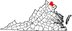
Watson, Virginia | |
---|---|
Coordinates: 38°59′36″N77°35′45″W / 38.99333°N 77.59583°W | |
Country | United States |
State | Virginia |
County | Loudoun |
Time zone | UTC−5 (Eastern (EST)) |
• Summer (DST) | UTC−4 (EDT) |
Watson is an unincorporated community in Loudoun County, Virginia.
Watson is a populated place located in Loudoun County at latitude 38.993 and longitude -77.596.
The elevation is 384 feet. Watson appears on the Arcola U.S. Geological Survey Map. Loudoun County is in the Eastern Time Zone (UTC -5 hours).
Loudoun County is in the northern part of the Commonwealth of Virginia in the United States. In 2020, the census returned a population of 420,959, making it Virginia's third-most populous county. Loudoun County's seat is Leesburg. Loudoun County is part of the Washington–Arlington–Alexandria, DC–VA–MD–WV Metropolitan Statistical Area. As of 2020, Loudoun County had a median household income of $147,111. Since 2008, the county has been ranked first in the U.S. in median household income among jurisdictions with a population of 65,000 or more.
Leesburg is a town in and the county seat of Loudoun County, Virginia, United States. Settlement in the area began around 1740, which is named for the Lee family, early leaders of the town. Located in the far northeast of the state, in the War of 1812 it was a refuge for important federal documents evacuated from Washington, DC, and in the Civil War, it changed hands several times.
Purcellville is a town in Loudoun County, Virginia. The population was 8,929 according to the 2020 Census. Purcellville is the major population center for Western Loudoun and the Loudoun Valley. Many of the older structures remaining in Purcellville reflect the Victorian architecture popular during the early twentieth century.
Northern Virginia, locally referred to as NOVA or NoVA, comprises several counties and independent cities in the Commonwealth of Virginia in the United States. The region radiates westward and southward from Washington, D.C. With 3,238,706 people according to 2022 Census estimates, it is the most populous region of Virginia and the Washington metropolitan area.
Ashburn is a census-designated place (CDP) in Loudoun County, Virginia, United States. At the 2010 United States Census, its population was 43,511, up from 3,393 twenty years earlier. It is 30 miles (48 km) northwest of Washington, D.C., and part of the Washington metropolitan area.
Virginia State Route 7 (VA 7) is a major primary state highway and busy commuter route in northern Virginia, United States. It travels southeast from downtown Winchester to SR 400 in downtown Alexandria. Its route largely parallels those of the Washington & Old Dominion Trail and the Potomac River. Between its western terminus and Interstate 395 (I-395), SR 7 is part of the National Highway System. In 1968, the Virginia State Highway Commission designated the road as the "Harry Flood Byrd Highway" between Alexandria and Winchester to commemorate Harry F. Byrd Sr. (1887–1966).
South Riding is a census-designated place and planned community in Loudoun County, Virginia, United States. The South Riding homeowner association was founded in January 1995 to provide services to the community. Neighboring U.S. Route 50 and State Route 28 provide access to the Dulles/Reston/Tysons Corner technology corridor and other major employment centers in Northern Virginia and Washington, D.C.
Loudoun County Public Schools (LCPS) is a branch of the Loudoun County, Virginia, United States government, and administers public schools in the county. LCPS's headquarters is located at 21000 Education Court in Ashburn, an unincorporated section of the county.
U.S. Route 50 is a transcontinental highway which stretches from Ocean City, Maryland to West Sacramento, California. In the U.S. state of Virginia, US 50 extends 86 miles (138 km) from the border with Washington, D.C. at a Potomac River crossing at Rosslyn in Arlington County to the West Virginia state line near Gore in Frederick County.
The Loudoun Rangers, also known as Mean's Rangers for their commander, Samuel C. Means, was a partisan cavalry unit raised in Loudoun County, Virginia, that fought for the Union during the American Civil War. The Rangers have the distinction of being the only unit raised in present-day Virginia to serve in the Union Army.
Broad Run is a tributary of the Potomac River in Loudoun County, Virginia. The creek, located between Goose Creek and Sugarland Run, principally drains portions of eastern Loudoun County, as well as a small portion of western Fairfax County.
The 8th Virginia Infantry Regiment was a Confederate infantry regiment raised by Colonel Eppa Hunton in Leesburg, Virginia on May 8, 1861. The unit comprised six companies from Loudoun, two companies from Fauquier, one company from Fairfax and one company from Prince William. Initial regimental officers included: Lt. Colonel Charles B. Tebbs, Major Norborne Berkeley, John M. Orr - Quartermaster, Dr. Richard H. Edwards - Surgeon, Charles F. Linthicum - Chaplain. After Eppa Hunton's promotion to brigadier general in August 1863, in part based on his valor during the Battle of Gettysburg, particularly during Pickett's Charge, Norborne Berkeley was promoted to command the 8th Virginia, and his brother Edmund became the Lieut. Colonel, his brother William Berkeley, Major, and Charles Berkeley became the senior Captain of what then became known as the "Berkeley Regiment." Nonetheless, Norborne, William and Charles Berkeley were all in Union prisoner of war camps and their brother Edmund still recovering from his Gettysburg wound on August 9.
Loudoun County Transit is a public-transportation service provided by the Loudoun County, Virginia government. Loudoun County Transit provides fixed routes and on-demand/paratransit bus service.
This is a list of the National Register of Historic Places listings in Loudoun County, Virginia.
The Loudoun County Sheriff's Office (LCSO) is the primary law enforcement agency within Loudoun County, Virginia and is the largest Sheriff's Office in the Commonwealth of Virginia. The agency is currently headed by Sheriff Michael L. Chapman who was last re-elected in 2019.
Dulles Town Center is a census-designated place (CDP) in Loudoun County, Virginia, United States. It is located about 7 miles (11 km) north of Washington Dulles International Airport. The CDP is the location of the Dulles Town Center shopping mall, for which it is named. The United States Postal Service considers Dulles Town Center to be a subsection of Dulles, which is itself a subsection of Sterling; none of these locations is an incorporated municipality.
One Loudoun is a census-designated place (CDP) in Loudoun County, Virginia, United States. It is a mixed-use development just south of Virginia State Route 7, 29 miles (47 km) northwest of Washington, D.C., and 7 miles (11 km) southeast of Leesburg. One Loudoun was developed since the 2010 census, so it was not recognized as a census-designated place until the 2020 census. The community has an Ashburn mailing address.
The 2017 Virginia lieutenant gubernatorial election was held on November 7, 2017. After the party primary elections were held, the major party nominees were Jill Vogel (Republican) and Justin Fairfax (Democrat). The incumbent Lieutenant Governor, Democrat Ralph Northam, declined to run for re-election in order to run for Governor. In the general election on November 7, 2017, Democratic nominee Justin Fairfax defeated Republican state Senator Jill Vogel to become the 41st Lieutenant Governor of Virginia.
John Joseph Bell is an American politician and a retired United States Air Force officer. A Democrat, he currently serves in the Virginia Senate by representing the 13th district. From 2016 to 2020 he served as a member of the Virginia House of Delegates, representing the 87th District. Both districts are located in Loudoun County and Prince William County.
John Carroll Leon Whitbeck Jr. is an American attorney and Republican Party official from Loudoun County, Virginia. Whitbeck was the chairman of the Republican Party of Virginia from 2015 to 2018.