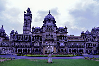
Vadodara, also known as Baroda, is the second-largest city in the Indian state of Gujarat. It serves as the administrative headquarters of the Vadodara district and is situated on the banks of the Vishwamitri River, 141 kilometres (88 mi) from the state capital of Gandhinagar. The railway line and National Highway 8, which connect Delhi with Mumbai, pass through Vadodara. The city is named for its abundance of Banyan (Vad) plants. Vadodara is also locally referred to as the Sanskari Nagari and Kala Nagari of India.

Kutch district is a district of Gujarat state in western India, with its headquarters (capital) at Bhuj. Covering an area of 45,674 km², it is the largest district of India. The area of Kutch District is larger than the entire area of states like Haryana (44,212 km2) and Kerala (38,863 km2) The population of Kutch is about 2,092,371. It has 10 Talukas, 939 villages and 7 Municipalities. The Kutch district is home to the Kutchi people who speak the Kutchi language.

Sabarkantha district is one of the 33 districts of Gujarat state of India and is located in the northeastern part of the state. The administrative headquarters of the district are located in Himmatnagar.

Mehsana, also spelled Mahesana, is a city and municipality in Mehsana district, in the Indian state of Gujarat. Established in 14th century, the city was under Gaekwads of Baroda State from 18th century to the independence of India in 1947. The municipality was established in 1919–20. The town has population of about 185,000. Dairy, oil and natural gas are major industries while there are several small and medium enterprises in the city.

Anand is the administrative centre of Anand District in the state of Gujarat, India. It is administered by Anand Municipality. It is part of the region known as Charotar, consisting of Anand and Kheda districts.

Amreli district is one of the 33 administrative districts of the state of Gujarat in western India. The district headquarters are located at Amreli. The district occupies an area of 6,760 km2 and has a population of 1,514,190 of which 22.45% were urban. Amreli is the land of Yogiji Maharaj, Danbapu, Sage Muldas, Sage Bhojalrambapa, Sage Muktanand Swami, Magician K.Lal, Zaverchand Megahani's place (Bagasara), Dr. Jivaraj Mehata etc. Amreli covers Gir National forest sanctuary area. Now it is developing as a Hub of Education.

Ahmedabad District comprises the city of Ahmedabad, in the central part of the state of Gujarat in western India. It is the seventh most populous district in India.

Gandhinagar district is an administrative division of Gujarat, India, whose headquarters are at Gandhinagar, the state capital. It was organized in 1964.
Dahod District is located in Gujarat state in western India, called after its administrative HQ. It has a population of 2,127,086, with a population density of 583 persons per km².
The administrative divisions of India are subnational administrative units of India; they are composed of a nested hierarchy of country subdivisions.

Tapi district is one of the 33 districts of Gujarat state in western India. It has seven talukas Vyara, Songadh, Nizar, Valod, Uchhal, Dolavan, Kukarmunda. Vyara town is the district headquarters. Tapi has 523 villages and two municipalitites. The district was formed in 2007 out of some talukas that were separated from Surat district. As of 2011, 90.15% of the district's population is rural and 84.2% of its population is Scheduled Tribes.
Vatadra (Vatadara) is one of the larger villages of Cambay county of Anand district in Gujarat state (India). It is a gram panchayat village. Because of its size, it is the only village in its gram panchayat. Prior to 1997, Vatadra was located in Kaira District.
Bhakha, also known as Bhakha (Gir) and Gir Bhakha, is a village / panchayat located in the Gir Gadhada Taluka of Gir Somnath district in Gujarat State, India. Earlier, until August 2013, Bhakha was part of Una Taluka and Junagadh district. The latitude 20.820009 and longitude 71.044327 are the geo-coordinate of the Village Thordi. Gandhinagar is the state capital of Thordi village which is located around 400 kilometres away from Thordi.
Dron is a village / panchayat, located in the Gir Gadhada Taluka of Gir Somnath district in Gujarat State, India. Earlier, until August 2013, Dron was part of Una Taluka and Junagadh district. The latitude 20.928161 and longitude 70.949985 are the geo-coordinate of the Village Dron. Gandhinagar is the state capital of Dron village which is located around 362 kilometres away from Dron.
Jhudvadli, Also spelled as Zudvadli or Judvadli, is a village / panchayat located in the Gir Gadhada Taluka of Gir Somnath district in Gujarat, India. Earlier, until August 2013, Jhudvadli was part of Una Taluka and Junagadh district. The latitude 20.889838 and longitude 70.992009 are the geo-coordinate of the Village Jhudvadli. Gandhinagar is the state capital of Jhudvadli village which is located around 400 kilometres away from Jhudvadli.
Jhanjhariya, also misspelled as Janjariya or Zanjariya, is a village / panchayat located in the Gir Gadhada Taluka of Gir Somnath district in Gujarat State, India. Until August 2013, Jhanjhariya was part of Una Taluka and Junagadh district. The latitude 20.857829 and longitude 70.87836 are the geo-coordinate of the Village Jhanjhariya. Gandhinagar is the state capital of Jhanjhariya village which is located around 400 kilometres away from Jhanjhariya.
Kaneri is a village / panchayat located in the Gir Gadhada Taluka of Gir Somnath district in Gujarat State, India. Earlier, until August 2013, Kaneri was part of Una Taluka and Junagadh district. The latitude 20.845802 and longitude 70.89972 are the geo-coordinate of the Village Kaneri. Gandhinagar is the state capital of Kaneri village which is located around 400 kilometres away from Kaneri.
Undari is a village / panchayat located in the Gir Gadhada Taluka of Gir Somnath district in Gujarat, India. Earlier, until August 2013, Undari was part of Una Taluka and Junagadh district. The latitude 20.851433 and longitude 70.959487 are the geo-coordinate of the Village Undari. Gandhinagar is the state capital of Undari village which is located around 400 kilometres away from Undari.
Ambavad is a village / panchayat located in the Gir Gadhada Taluka of Gir Somnath district in Gujarat State, India. Earlier, until August 2013, Ambavad was part of Una Taluka and Junagadh district. The latitude 20.837349 and longitude 70.923194 are the geo-coordinate of the Village Ambavad. Gandhinagar is the state capital of Ambavad village which is located around 400 kilometres away from Ambavad.
Kanakiya is a village / panchayat located in the Gir Gadhada Taluka of Gir Somnath district in Gujarat State, India. Earlier, until August 2013, Kanakiya was part of Una Taluka and Junagadh district. The latitude 20.832226 and longitude 70.896326 are the geo-coordinate of the Village Kanakiya. Gandhinagar is the state capital of Kanakiya village which is located around 400 kilometres away from Kanakiya.