
Maharashtra is a state in the western peninsular region of India occupying a substantial portion of the Deccan Plateau. It is bordered by the Arabian Sea to the west, the Indian states of Karnataka and Goa to the south, Telangana to the southeast and Chhattisgarh to the east, Gujarat and Madhya Pradesh to the north, and the Indian union territory of Dadra and Nagar Haveli and Daman and Diu to the northwest. Maharashtra is the second-most populous state in India.

Solapur is a city located in the south-western region of the Indian state of Maharashtra, close to its border with Karnataka. Solapur is located on major highway, rail routes between Mumbai, Pune, Bangalore and Hyderabad, with a branch line to the cities of Kalaburagi and Vijayapura in the neighbouring state of Karnataka. Solapur International Airport is under construction. It is classified as A1 Tier and B-1 class city by House Rent Allowance (HRA) classification by the Government of India. It is the seventh biggest Metropolis Urban Agglomeration and 11th most populated city in Maharashtra as well as 43rd largest urban agglomeration and 49th most populous city in India.
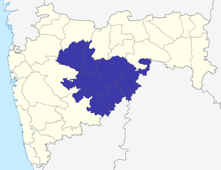
Marathwada is a proposed state and geographical region of the Indian state of Maharashtra. It was formed during the Nizam's rule and was part of the then Hyderabad State. The region coincides with the Aurangabad division of Maharashtra. It borders the states of Karnataka and Telangana, and it lies to the west of the Vidarbha and east of Uttar Maharashtra regions of Maharashtra. The largest city of Marathwada is Aurangabad. Its people speak Marathi and Deccani Urdu.
Satara is a city located in the Satara District of Maharashtra state of India, near the confluence of the river Krishna and its tributary, the Venna. The city was established in the 16th century and was the seat of the Chhatrapati of Maratha Empire, Shahu I.
Akola is a major city in the Vidarbha region of the Indian state of Maharashtra. The third largest city in Eastern Maharashtra after Nagpur and Amravati, it is located about 580 kilometres (360 mi) east of the state capital, Mumbai, and 250 kilometres (160 mi) west of the second capital, Nagpur. Akola is the administrative headquarters of the Akola district located in the Amravati division.

Yavatmal ( is a city and municipal council in the Indian state of Maharashtra. It is the administrative headquarters of Yavatmal District. Yavatmal is around 90 km away from divisional headquarters Amravati while it is 670 km away from the state capital Mumbai and 150 km south west of Nagpur.
Bhandara is a city located in the Bhandara district of Maharashtra State of India, near the bank of confluence of river Wainganga and its tributary Sur. It serves the administrative headquarters of eponymous Bhandara Taluka and Bhandara district. It is connected with NH-53 and NH-247.
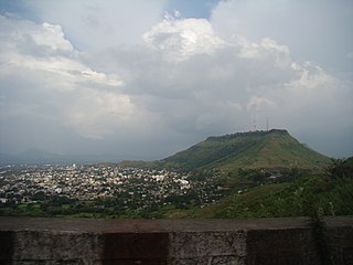
Puntamba is a market town situated on the banks of the Godavari River in Rahata taluka, Ahmednagar District in the state of Maharashtra in India. The village contains the 14th and the final resting place of the sage Changdev. The town is known for old temples and traditional schools that specialize in study of the Hindu scriptures or the Vedas.

Kalameshwar-Bramhani is a city and a municipal council also a major Industrial hub in Nagpur district in the Indian state of Maharashtra. It is connected to National Highways NH-353I, NH-353J & NH-547E.
Nilanga is a town with a municipal council in Latur District in the Indian state of Maharashtra. It is also the headquarters for Nilanga Taluka. It is the Taluka Headquarter.

Sausar (Saunsar) is a Municipal Council in the central India in the state of Madhya Pradesh. Sausar lies in Vidharbha region, Nagpur is the center for all the economic activities in this region which is just 72 km from Sausar. More than 90 per cent of farmers produce oranges. Cotton is grown in large quantities in the local area.
The Belagavi border dispute or Belgaon border dispute is a dispute between the Indian states of Karnataka and Maharashtra over the administration of Belagavi. Belagavi is now a district in Karnataka, but in British India, was part of the Bombay Presidency, together with present-day Gujarat, Maharashtra, and certain areas of Karnataka.
Sakri is a census town and a taluka in the Dhule District of the Nashik division, Maharashtra state, India. The town of Sakri is the administrative headquarters for Sakri Taluka. Another Sakri is in Bihar, which is now a railway junction.

Parner taluka is a taluka in Ahmednagar district in the state of Maharashtra in western India.

Maharashtra is a state in the western region of India. It is India's second-most populous state and third-largest state by area. The region that comprises the state has a long history dating back to approximately 1300–700 BCE, although the present-day state was not established until 1960 CE.
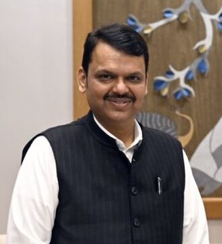
Devendra Gangadharrao Fadnavis is an Indian politician who is serving as the Deputy Chief Minister of Maharashtra from 30 June 2022 alongside Ajit Pawar who was sworn in as the Deputy Chief Minister of Maharashtra for the 5th time on 2 July 2023. He also served as the 18th Chief Minister of Maharashtra from 31 October 2014 to 12 November 2019, Leader of the Opposition, Maharashtra Legislative Assembly from 2019 to 2022 and the President of BJP, Maharashtra state unit from 2013 to 2015. Having been sworn in at the age of 44, he is the second-youngest Chief Minister in Maharashtra's history after Sharad Pawar. He served a 5-day long second term as Chief Minister during the 2019 Maharashtra political crisis, before resigning on 28 November 2019. A member of the Bharatiya Janata Party and the Rashtriya Swayamsevak Sangh, Fadnavis has represented the Nagpur South West constituency in the Maharashtra Legislative Assembly since 2009 and Nagpur West from 1999 to 2009. He was also Mayor of Nagpur from 1997 to 2001.
Kundal is a town in Palus Taluka within the Sangli District of southwestern Maharashtra, India. It has a population of 18,287 people - 9,432 males and 8,855 females according to the 2011 census. Kundal is located 40 kilometres north of the district capital, Sangli And 5km from palus
Mahiravani is a historical village in Nashik district of Maharashtra state of India. It is on the way from Nashik to Trimbakeshwar. The population of the village is around two thousand. Spoken language is Marathi.

The Maratha Kranti Morcha, loosely translated as "Maratha revolutionary demonstration" in the Marathi language, is a series of silent and pragmatic protests organized by the Maratha community in various cities across India as well as overseas. Other groups, such as religious minorities including Muslims, have also supported the Morcha. The impetus for the rallies was the rape and murder of a 15-year-old girl in Kopardi village, Maharashtra, on 13 July 2016. The protesters have demanded the death sentence for the rapists. Maratha caste dominate the power and cultural structure in Maharashtra owing to their numerical strength.
National Highway 752G, commonly referred to as NH 752G is a national highway in India. It is a spur road of National Highway 52. NH-752G traverses the states of Madhya Pradesh and Maharashtra in India.
