
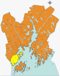
Vågsbygd is a borough and district in the city of Kristiansand in Vest-Agder county, Norway. It is the largest borough and district in Kristiansand. Until 1965, Vågsbygd was a part of Oddernes municipality. The borough includes the districts of Flekkerøy, Voiebyen, Vågsbygd/Augland, and Slettheia. The Kristiansand Cannon Museum on Kroodden is an authentic fortress from World War II.
Voiebyen is a district in the city of Kristiansand in Vest-Agder county, Norway. The district has a population of about 6,000 people in 2014 and it is a part of the borough of Vågsbygd in the southwestern part of the city. The district of Vågsbygd lies to the north, and the district of Flekkerøy lies to the south on the island of Flekkerøya.
Hannevika or Hannevig / Hannevik is a neighbourhood in the city of Kristiansand in Vest-Agder county, Norway. It is located in the borough of Grim and in the district of Tinnheia. The neighborhood is located along the European route E39 highway and the start of Norwegian County Road 456. Hannevika is a large industrial area. Glencore and Hennig-Olsen Iskremfabrikk are the two largest industries located there. Hannevika is located southeast of Eigevannskollen, northeast of Kartheia, and south of Kolsberg.

Møvik or Møvig is a neighbourhood in the city of Kristiansand in Vest-Agder county, Norway. The neighborhood is located in the borough of Vågsbygd and in the district of Voiebyen. It's located in the southeast part of the borough along the shore. It lies north of Spinneren and Krooden, southwest of Ternevig, and south of Voie.

Koboltveien is a neighbourhood in the city of Kristiansand in Vest-Agder county, Norway. It is located in the borough of Grim and in the district of Tinnheia. It mostly consists of apartments and it is close to the lake Eigevann. The Tinnheia torv neighborhood lies next to Kolboltveien.

Tømmerstø is a neighbourhood in the city of Kristiansand in Vest-Agder county, Norway. It's located in the borough of Oddernes and in the district of Randesund. The neighborhood of Odderhei lies to the northwest, Holte and Frikstad lie to the northeast, and Kongshavn lies to the southeast.
Ternevig is a neighbourhood in the city of Kristiansand in Vest-Agder county, Norway. The neighborhood is located in the borough of Vågsbygd and in the district of Voiebyen. Ternevig is northeast of Møvik, southeast of Voie, east of Møviklia, and west of the ocean and the island of Andøya. There is a small hospital located in Ternevig serving the borough of Vågsbygd. There is also a marina located in this neighborhood.

Kartheia is a neighbourhood in the city of Kristiansand in Vest-Agder county, Norway. It is located in the northern part of the borough of Vågsbygd and in the district of Slettheia. The neighborhood lies southwest of the junction of the European route E39 highway and the County Road 456. The district of Hellemyr lies to the north. Kartheia contains residential areas as well as a large industrial area. Gislemyr lies to the south, Trane lies to the west, and Hannevika lies to the east.

Hannevikåsen is a neighbourhood in the city of Kristiansand in Vest-Agder county, Norway. It is located in the borough of Grim and in the district of Tinnheia. It lies up the hill from Hannevika and Kolsdalen. The European route E39 highway runs underneath the south end of the neighborhood.
Kongshavn is a neighbourhood in the city of Kristiansand in Vest-Agder county, Norway. It's located in the borough of Oddernes and in the district of Randesund. The neighborhood of Frikstad lies to the north and Tømmerstø lies to the northwest. Kongshavn Pier is a large harbor with connections to islands outside of Randesund.
Holte is a neighbourhood in the city of Kristiansand in Vest-Agder county, Norway. It's located in the borough of Oddernes and in the district of Randesund. The neighborhood of Tømmerstø lies to the south and Frikstad lies to the east. Holte Junior High is the only junior high in Randesund.
Kroodden is a neighbourhood in the city of Kristiansand in Vest-Agder county, Norway. The neighborhood is located in the borough of Vågsbygd and in the district of Voiebyen. The Kristiansand Cannon Museum is located to the west of Kroodden. Kroodden is south of Spinneren along the coast. From Kroodden, the Flekkerøy Tunnel leads across the strait to the island of Flekkerøy.
Spinneren is a neighbourhood in the city of Kristiansand in Vest-Agder county, Norway. The neighborhood is located in the borough of Vågsbygd and in the district of Voiebyen. Spinneren is located along the coast, south of Møvik and north of Kroodden.
Steindalen is a neighbourhood in the city of Kristiansand in Vest-Agder county, Norway. The neighborhood is located in the borough of Vågsbygd and in the district of Voiebyen. Steindalen is north of Kroodden, south of Voieåsen, east of Voietun, and west of Møviklia.
Voieåsen is a neighbourhood in the city of Kristiansand in Vest-Agder county, Norway. The neighborhood is located in the borough of Vågsbygd and in the district of Voiebyen. Voieåsen is north of Møviklia, south of Voie, east of Voielia, and west of Møvik.
Voielia is a neighbourhood in the city of Kristiansand in Vest-Agder county, Norway. The neighborhood is located in the borough of Vågsbygd and in the district of Voiebyen. Voielia is north of Voietun, south of Rådyr, east of Bråvann, and west of Voieåsen.
Voietun is a neighbourhood in the city of Kristiansand in Vest-Agder county, Norway. The neighborhood is located in the borough of Vågsbygd and in the district of Voiebyen. Voietun is south of Voielia and west of Steindalen.
Rådyr is a neighbourhood in the city of Kristiansand in Vest-Agder county, Norway. The neighborhood is located in the borough of Vågsbygd and in the district of Voiebyen. The neighborhood of Rådyr is north of Voielia, south of Kjos Haveby, east of Bråvann, and west of Kjosbukta.
Åsane is a neighbourhood in the city of Kristiansand in Vest-Agder county, Norway. The neighborhood is located in the borough of Vågsbygd and in the district of Vågsbygd. The Åsane Elementary School serves the neighborhood. Åsane is north of Bråvann, south of Nordtjønnåsen, and west of Bjørklia.

Voie Church is a parish church in Kristiansand municipality in Vest-Agder county, Norway. It is located in the Møvik neighborhood in the district of Voiebyen in the borough of Vågsbygd in the city of Kristiansand. The church is part of the Voie parish in the Kristiansand arch-deanery in the Diocese of Agder og Telemark. The brick church was built in 1990 using plans by the architect Arild Lauvland. The fan-shaped church seats about 300 people, but it can be expanded to about 500 people.


