Volcanism of Indonesia

Last updated

Map of volcanoes in Indonesia Map indonesia volcanoes.gif
Map of volcanoes in Indonesia

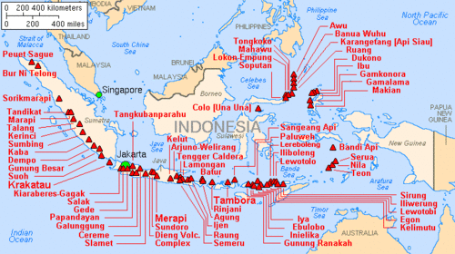
Indonesia is a volcanically active country, containing numerous major volcanoes. It has the most volcanoes of any country in the world, with 76 volcanoes that have erupted at least 1,171 times in total within historical times. [1] [2] [3] The Smithsonian Institution has 141 Indonesian entries in its volcano database. [4] Indonesia has around 130 active volcanoes that are part of the Pacific Ring of Fire, and it has suffered the highest numbers of eruptions resulting in fatalities, damage to arable land, debris flows, tsunamis, lava domes, and pyroclastic flows. Indonesia's most active volcanoes are Kelut and Mount Merapi on the island of Java. The majority of Indonesia's volcano are located on a 3,000 km long chain called the Sunda Arc. Here, the subduction of the Indian Ocean crust underneath the Asian Plate produced most of these volcanoes. [5]

Contents

History

Volcanic eruptions

The most severe eruptions on Earth in historical times took place in Indonesia. In 1815, the giant eruption of Mount Tambora, a stratovolcano, became the largest known eruption in the world during historical times, and it had such a large effect on the climate that the following year, 1816, in Europe was known as the year without summer. 40 km3 of ash were produced as a result of the eruption combined with the collapse of the caldera. About 90,000 people were killed as a result of Mt. Tambora's 1815 eruption, about 10,000 directly from the eruption and about 80,000 from crop loss and famine. [6] In 1883, the catastrophic eruption of Krakatoa, a volcanic island in Lampung, which registered as a 6 on the Volcanic Explosivity Index (VEI), and the tsunamis that ensued killed about 36,000 people, and approximately two-thirds of the original island was destroyed as well. [7] The 2010 the eruption of Mount Merapi, a stratovolcano, began in late October and continued into November. This eruption had a VEI of 4, and it also released a sulfur dioxide cloud between 12,000 and 15,000 m into the upper troposphere. [8]

Preparation

In 1920, the Volcanological Survey of Indonesia was created in order to investigate, record, and warn people about volcanoes within the Indonesian region. This group has helped aid in the evacuation of people living near Indonesian volcanoes since it was formed. For example, during the 1982 eruption of Galunggung, which had a Volcanic Explosivity Index of 4, 75,000 people were evacuated and 68 people died, and in 1988, 15,000 people were evacuated and there were no fatalities during the eruption of Makian. [9]

See also

Related Research Articles

<span class="mw-page-title-main">Mount Tambora</span> Active stratovolcano in Sumbawa in Indonesia

Mount Tambora, or Tomboro, is an active stratovolcano in West Nusa Tenggara, Indonesia. Located on Sumbawa in the Lesser Sunda Islands, it was formed by the active subduction zones beneath it. Before 1815, its elevation reached more than 4,300 metres high, making it one of the tallest peaks in the Indonesian archipelago.

<span class="mw-page-title-main">Stratovolcano</span> Type of conical volcano composed of layers of lava and tephra

A stratovolcano, also known as a composite volcano, is a conical volcano built up by many layers (strata) of hardened lava and tephra. Unlike shield volcanoes, stratovolcanoes are characterized by a steep profile with a summit crater and periodic intervals of explosive eruptions and effusive eruptions, although some have collapsed summit craters called calderas. The lava flowing from stratovolcanoes typically cools and solidifies before spreading far, due to high viscosity. The magma forming this lava is often felsic, having high to intermediate levels of silica, with lesser amounts of less viscous mafic magma. Extensive felsic lava flows are uncommon, but have traveled as far as 15 km (9 mi).

<span class="mw-page-title-main">Ring of Fire</span> Region around the rim of the Pacific Ocean where many volcanic eruptions and earthquakes occur

The Ring of Fire is a tectonic belt of volcanoes and earthquakes.

<span class="mw-page-title-main">Mount Merapi</span> Active stratovolcano in Central Java, Indonesia

Mount Merapi is an active stratovolcano located on the border between the province of Central Java and the Special Region of Yogyakarta, Indonesia. It is the most active volcano in Indonesia and has erupted regularly since 1548. It is located approximately 28 km (17 mi) north of Yogyakarta city which has a population of 2.4 million, and thousands of people live on the flanks of the volcano, with villages as high as 1,700 m (5,577 ft) above sea level.

<span class="mw-page-title-main">Cerro Negro</span> Active volcano in Nicaragua

Cerro Negro is an active volcano in the Cordillera de los Maribios mountain range in Nicaragua, about 10 km (6.2 mi) from the village of Malpaisillo. It is a very new volcano, the youngest in Central America, having first appeared in April 1850. It consists of a gravelly basaltic cinder cone, which contrasts greatly with the surrounding verdant hillsides, and gives rise to its name, which means Black Hill. Cerro Negro has erupted frequently since its first eruption. One unusual aspect of several eruptions has been the emission of ash from the top of the cone, while lava erupts from fractures at the base.

<span class="mw-page-title-main">Sunda Arc</span> Volcanic island arc in Indonesia

The Sunda Arc is a volcanic arc that produced the volcanoes that form the topographic spine of the islands of Sumatra, Nusa Tenggara, Java, the Sunda Strait, and the Lesser Sunda Islands. The Sunda Arc begins at Sumatra and ends at Flores, and is adjacent to the Banda Arc. The Sunda Arc is formed via the subduction of the Indo-Australian Plate beneath the Sunda and Burma plates at a velocity of 63–70 mm/year.

<span class="mw-page-title-main">Mount Rinjani</span> Volcano in Lombok, Indonesia

Mount Rinjani is an active volcano in Indonesia on the island of Lombok. Administratively the mountain is in the Regency of North Lombok, West Nusa Tenggara. It rises to 3,726 metres (12,224 ft), making it the second highest volcano in Indonesia. It is also the highest point in the Indonesian province of West Nusa Tenggara.

<span class="mw-page-title-main">Paluweh</span>

Paluweh, also known as Rokatenda, is a stratovolcano that forms the small island of Palu'e, north of Flores Island in Sikka Regency in the province of East Nusa Tenggara, Indonesia. While the volcano rises about 3,000 m (9,840 ft) above the sea floor, its cone rises just 875 metres (2,871 ft) above sea level and is the highest point on the island.

The Decade Volcanoes are 16 volcanoes identified by the International Association of Volcanology and Chemistry of the Earth's Interior (IAVCEI) as being worthy of particular study in light of their history of large, destructive eruptions and proximity to densely populated areas. The Decade Volcanoes project encourages studies and public-awareness activities at these volcanoes, with the aim of achieving a better understanding of the volcanoes and the dangers they present, and thus being able to reduce the severity of natural disasters.

<span class="mw-page-title-main">Mount Talang</span> Active stratovolcano in west Sumatra, Indonesia

Mount Talang (2,597 m [8,520 ft]) is an active stratovolcano in West Sumatra, Indonesia. Talang has two crater lakes on its flanks, the largest of which is 1 by 2 kilometres wide and is called Lake Talang.

<span class="mw-page-title-main">Semeru</span> Stratovolcano in Indonesia

The Semeru, or Mount Semeru is an active volcano located in East Java, Indonesia. It is located in a subduction zone, where the Indo-Australian plate subducts under the Eurasia plate. It is the highest mountain on the island of Java. The name "Semeru" is derived from Meru, the central world mountain in Hinduism, or Sumeru, the abode of gods. This stratovolcano is Mahameru, meaning "The Great Mountain" in Sanskrit. It is one of the more popular hiking destinations in Indonesia.

<span class="mw-page-title-main">Mount Merbabu</span> Stratovolcano in Central Java, Indonesia

Mount Merbabu is a dormant stratovolcano in Central Java province on the Indonesian island of Java. The name Merbabu could be loosely translated as 'Mountain of Ash' from the Javanese combined words; Meru means "mountain" and awu or abu means "ash".

<span class="mw-page-title-main">Mount Colo</span> Stratovolcano in Indonesia

Colo is a stratovolcano in Indonesia. It forms the small island of Una-Una at the middle of the Gulf of Tomini, the northern part of Sulawesi. The volcano is broad and has a low profile with only 507 metres (1,663 ft) above the sea level. It contains a 2 kilometres (1.2 mi) wide caldera with a small volcanic cone inside. Only three eruptions have been recorded in the history with two of them causing damage.

<span class="mw-page-title-main">Mount Gamkonora</span>

Mount Gamkonora is a stratovolcano on Halmahera island, Indonesia. With an elevation of 1,560 metres (5,118 ft), it is the highest peak on the island. It has produced an elongated series of craters along the north–south rift.

<span class="mw-page-title-main">1815 eruption of Mount Tambora</span> Catastrophic volcanic eruption in Indonesia in 1815

Mount Tambora is a volcano on the island of Sumbawa in present-day Indonesia, then part of the Dutch East Indies, and its 1815 eruption was the most powerful volcanic eruption in recorded human history. This volcanic explosivity index (VEI) 7 eruption ejected 37–45 km3 of dense-rock equivalent (DRE) material into the atmosphere, and was the most recent confirmed VEI-7 eruption.

<span class="mw-page-title-main">2010 eruptions of Mount Merapi</span> Volcanic eruption of Mount Merapi in Indonesia

In late October 2010, Mount Merapi in border of Central Java and Special Region of Yogyakarta, Indonesia began an increasingly violent series of eruptions that continued into November. Seismic activity around the volcano increased from mid-September onwards, culminating in repeated outbursts of lava and volcanic ash. Large eruption columns formed, causing numerous pyroclastic flows down the heavily populated slopes of the volcano. The 2010 eruption of Merapi was the volcano's largest since 1872.

References

  1. Sample, Ian (1 March 2006). "Scientists find lost civilisation buried by volcano". The Guardian. ISSN   0261-3077. Archived from the original on 10 January 2024. Retrieved 10 January 2024.
  2. Evita, Maria; et al. (12 March 2021). "Photogrammetry Using Intelligent-Battery UAV in Different Weather for Volcano Early Warning System Application". Journal of Physics: Conference Series. 1772 (012017): 2. doi:10.1088/1742-6596/1772/1/012017/pdf.
  3. antaranews.com (16 July 2011). "News Focus: Mt Lokon eruption forces mass evacuation". Antara News. Retrieved 12 January 2024.
  4. "What country has the most volcanoes?". ask.com.
  5. "The Indonesia Region". Smithsonian Institution. 2013. Retrieved 23 October 2016.
  6. "How do volcanoes affect people?". oregonstate.edu. Oregon State University. Retrieved 23 October 2016.
  7. "KRAKATAU, INDONESIA (1883)". sdsu.edu. Retrieved 23 October 2016.
  8. "Eruption at Mount Merapi, Indonesia". NASA Earth Observatory. 2010. Retrieved 23 October 2016.
  9. "Tectonics of Indonesia". oregonstate.edu. Oregon State University. Retrieved 23 October 2016.