Vrčice

Last updated
Vrčice
Vrcice Slovenia 2.jpg
Slovenia location map.svg
Red pog.svg
Vrčice
Location in Slovenia
Coordinates: 45°38′50.83″N15°8′33.07″E / 45.6474528°N 15.1425194°E / 45.6474528; 15.1425194 Coordinates: 45°38′50.83″N15°8′33.07″E / 45.6474528°N 15.1425194°E / 45.6474528; 15.1425194
Country Flag of Slovenia.svg Slovenia
Traditional region Lower Carniola
Statistical region Southeast Slovenia
Municipality Semič
Area
  Total 0.75 km2 (0.29 sq mi)
Elevation 481.3 m (1,579.1 ft)
Population (2002)
  Total 48
[1]

Vrčice (pronounced  [ʋəɾˈtʃiːtsɛ] ; in older sources also Brčice, [2] German : Wertschitz or Wertschitsch [2] [3] ) is a small settlement in the Municipality of Semič in Slovenia. The area is part of the historical region of Lower Carniola. The municipality is now included in the Southeast Slovenia Statistical Region. [4]

German language West Germanic language

German is a West Germanic language that is mainly spoken in Central Europe. It is the most widely spoken and official or co-official language in Germany, Austria, Switzerland, South Tyrol (Italy), the German-speaking Community of Belgium, and Liechtenstein. It is also one of the three official languages of Luxembourg and a co-official language in the Opole Voivodeship in Poland. The languages which are most similar to German are the other members of the West Germanic language branch: Afrikaans, Dutch, English, the Frisian languages, Low German/Low Saxon, Luxembourgish, and Yiddish. There are also strong similarities in vocabulary with Danish, Norwegian and Swedish, although those belong to the North Germanic group. German is the second most widely spoken Germanic language, after English.

Municipality of Semič Municipality in Slovenia

The Municipality of Semič is a municipality in Slovenia in the traditional region of White Carniola in southeastern Slovenia. The municipality is included in the Southeast Slovenia Statistical Region. Its seat is the settlement Semič.

Slovenia republic in Central Europe

Slovenia, officially the Republic of Slovenia, is a sovereign state located in southern Central Europe at a crossroads of important European cultural and trade routes. It is bordered by Italy to the west, Austria to the north, Hungary to the northeast, Croatia to the southeast, and the Adriatic Sea to the southwest. It covers 20,273 square kilometers (7,827 sq mi) and has a population of 2.07 million. One of the successor states of the former Yugoslavia, Slovenia is a parliamentary republic and a member of the United Nations, of the European Union, and of NATO. The capital and largest city is Ljubljana.

Contents

Name

The Slovene name Vrčice is believed to be derived from the German name Wertschitz and that, in turn, from the Slavic prepositional phrase *vъ rěčicě 'in/at the creek'. [5] Vrčica Creek flows through the village.

Church

Assumption Church Vrcice Slovenia - church.jpg
Assumption Church

The local church is dedicated to the Assumption of Mary and belongs to the Parish of Semič. It dates to the mid-18th century. [6]

Church (building) building constructed for Christian worship

A church building or church house, often simply called a church, is a building used for Christian religious activities, particularly for Christian worship services. The term is often used by Christians to refer to the physical buildings where they worship, but it is sometimes used to refer to buildings of other religions. In traditional Christian architecture, the church is often arranged in the shape of a Christian cross. When viewed from plan view the longest part of a cross is represented by the aisle and the junction of the cross is located at the altar area.

Assumption of Mary the bodily taking up of the Virgin Mary into Heaven at the end of her earthly life

The Assumption of Mary into Heaven is, according to the beliefs of the Catholic Church, Eastern and Oriental Orthodoxy, the bodily taking up of the Virgin Mary into Heaven at the end of her earthly life.

A parish is a territorial entity in many Christian denominations, constituting a division within a diocese. A parish is under the pastoral care and clerical jurisdiction of a parish priest, who might be assisted by one or more curates, and who operates from a parish church. Historically, a parish often covered the same geographical area as a manor. Its association with the parish church remains paramount.

Related Research Articles

Semič Settlement in Lower Carniola, Slovenia

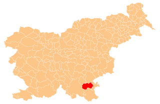
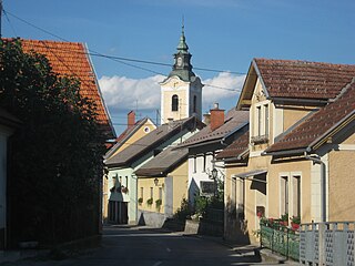
Semič is a settlement in southeastern Slovenia. It is the administrative centre of the Municipality of Semič.

Blatnik pri Črmošnjicah Place in Lower Carniola, Slovenia

Blatnik pri Črmošnjicah is a small settlement in the Municipality of Semič in Slovenia. It was inhabited by Gottschee Germans that were mostly expelled in 1941 during the Second World War. The area is part of the historical region of Lower Carniola. The municipality is now included in the Southeast Slovenia Statistical Region.

Štrekljevec Place in Lower Carniola, Slovenia

Štrekljevec is a village in the Municipality of Semič in Slovenia. The area is part of the historical region of Lower Carniola. The municipality is now included in the Southeast Slovenia Statistical Region.

Brezje pri Rožnem Dolu in Lower Carniola, Slovenia

Brezje pri Rožnem Dolu is a small settlement in the Municipality of Semič in Slovenia. The municipality is included in the Southeast Slovenia Statistical Region. The entire area is part of the historical region of Lower Carniola.

Brezje pri Vinjem Vrhu Place in Lower Carniola, Slovenia

Brezje pri Vinjem Vrhu is a settlement in the hills south of Semič in southeastern Slovenia. The area is part of the historical region of Lower Carniola. The Municipality of Semič is now included in the Southeast Slovenia Statistical Region.

Brstovec in Lower Carniola, Slovenia

Brstovec is settlement in the Municipality of Semič in Slovenia. It lies south of Semič in the historical region of Lower Carniola. The municipality is now included in the Southeast Slovenia Statistical Region.

Črešnjevec pri Semiču in Lower Carniola, Slovenia

Črešnjevec pri Semiču is a small village east of Semič in southeastern Slovenia. The Municipality of Semič is part of the historical region of Lower Carniola. The municipality is now included in the Southeast Slovenia Statistical Region.

Črmošnjice, Semič Place in Lower Carniola, Slovenia

Črmošnjice is a village in the Municipality of Semič in Slovenia. It lies on the eastern edge of the Gottschee region that used to be inhabited by Gottschee Germans expelled in 1941 during the Second World War. The area is part of the historical region of Lower Carniola. The municipality is now included in the Southeast Slovenia Statistical Region.

Gornje Laze in Lower Carniola, Slovenia

Gornje Laze is a small settlement in the Municipality of Semič in southeastern Slovenia. The municipality is included in the Southeast Slovenia Statistical Region. The area is part of the historical region of Lower Carniola.

Hrib pri Rožnem Dolu in Lower Carniola, Slovenia

Hrib pri Rožnem Dolu is a small settlement in the hills west of Rožni Dol in the Municipality of Semič in Slovenia. The area is part of the historical region of Lower Carniola. The municipality is now included in the Southeast Slovenia Statistical Region.

Komarna Vas Place in Lower Carniola, Slovenia

Komarna Vas is a village on the eastern edge of Kočevski Rog in the Municipality of Semič in Slovenia. The area is part of the historical region of Lower Carniola. The municipality is now included in the Southeast Slovenia Statistical Region.

Krupa, Semič Place in White Carniola, Slovenia

Krupa is a small village in the Municipality of Semič in Slovenia. It lies at the source of the Krupa River, a left tributary of the Lahinja River. The area is part of the historical region of White Carniola. The municipality is now included in the Southeast Slovenia Statistical Region.

Krvavčji Vrh in Lower Carniola, Slovenia

Krvavčji Vrh is a village in the Municipality of Semič in Slovenia. It lies on the local road leading east out of Semič to Metlika. The area is part of the historical region of Lower Carniola. The municipality is now included in the Southeast Slovenia Statistical Region.

Planina, Semič Place in Lower Carniola, Slovenia

Planina is a village in the Municipality of Semič in Slovenia. It lies on the southern slopes of Mount Mirna in the southern part of Kočevje Rog. It was inhabited by Gottschee Germans that were expelled in 1941 during the Second World War. The area is part of the historical region of Lower Carniola. The municipality is now included in the Southeast Slovenia Statistical Region.

Pribišje in Lower Carniola, Slovenia

Pribišje is a small settlement in the hills north of Semič in Slovenia. The Municipality of Semič is included in the Southeast Slovenia Statistical Region. The area is also part of the historical region of Lower Carniola.

Rožni Dol in Lower Carniola, Slovenia

Rožni Dol is a village in the Municipality of Semič in Slovenia. The area is part of the historical region of Lower Carniola. The municipality is now included in the Southeast Slovenia Statistical Region.

Stranska Vas pri Semiču Place in Lower Carniola, Slovenia

Stranska Vas pri Semiču is a village on the right bank of the Krupa River in the Municipality of Semič in Slovenia. The area is part of the historical region of Lower Carniola. The municipality is now included in the Southeast Slovenia Statistical Region.

Trebnji Vrh Village in Lower Carniola, Slovenia

Trebnji Vrh is a small settlement in the Municipality of Semič in Slovenia. It lies in the hills south of Semič in the historical region of Lower Carniola. The municipality is now included in the Southeast Slovenia Statistical Region.

Vinji Vrh pri Semiču Village in Lower Carniola, Slovenia

Vinji Vrh pri Semiču is a village in the Municipality of Semič in southeastern Slovenia. The area is part of the historical region of Lower Carniola. The municipality is now included in the Southeast Slovenia Statistical Region.

Travnik, Semič in Lower Carniola, Slovenia

Travnik is a remote abandoned settlement in the Municipality of Semič in southern Slovenia. The area is part of the traditional region of Lower Carniola and is now included in the Southeast Slovenia Statistical Region. Its territory is now part of the village of Komarna Vas.

References

  1. Statistical Office of the Republic of Slovenia
  2. 1 2 Leksikon občin kraljestev in dežel zastopanih v državnem zboru, vol. 6: Kranjsko. 1906. Vienna: C. Kr. Dvorna in Državna Tiskarna, p. 14.
  3. Statistische Zentralkommission. 1919. Spezialortsrepertorium von Krain: Bearbeitet auf Grund der Ergebnisse der Volkszählung vom 31. Dezember 1910. Vienna: Verlag der K. K. Hof- und Staatsdruckerei, p. 101.
  4. Semič municipal site
  5. Bezlaj, France (ed.). 1995. Etimološki slovar slovenskega jezika, vol. 3. Ljubljana: SAZU, pp. 168–169.
  6. "EŠD 2259". Registry of Immovable Cultural Heritage (in Slovenian). Ministry of Culture of the Republic of Slovenia. Retrieved 14 March 2011.