Related Research Articles

Daviess County ( "Davis"), is a county in Kentucky. As of the 2020 census, the population was 103,312. Its county seat is Owensboro. The county was formed from part of Ohio County on January 14, 1815.

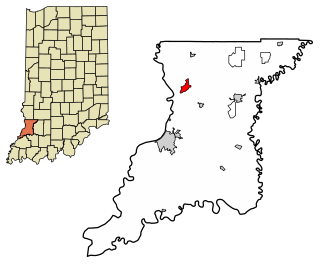
Daviess County is a county in the U.S. state of Indiana. As of the 2020 United States Census, the population was 33,381. The county seat is Washington. About 15% of the county's population is Amish of Swiss origin, as of 2017.

The White River is an American two-forked river that flows through central and southern Indiana and is the main tributary to the Wabash River. Via the west fork, considered to be the main stem of the river by the U.S. Board on Geographic Names, the White River is 362 miles (583 km) long. Indiana's capital, Indianapolis, is located on the river. The two forks meet just north of Petersburg and empty into the Wabash River at Mount Carmel, Illinois.

The Wabash Valley is a region located in sections of both Illinois and Indiana. It is named for the Wabash River and, as the name is typically used, spans the middle to the middle-lower portion of the river's valley and is centered at Terre Haute, Indiana. The term Wabash Valley is frequently used in local media in Clinton, Lafayette, Mount Carmel, Princeton, Terre Haute, and Vincennes all of which are either on or near the Lower Wabash River.

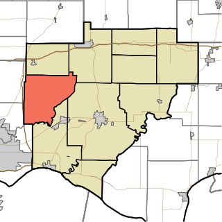
Harrison Township is one of ten townships in Daviess County, Indiana. As of the 2020 census, its population was 689 and it contained 308 housing units.
Campbell Township is one of ten townships in Warrick County, Indiana, United States. As of the 2010 census, its population was 906 and it contained 353 housing units.

Hart Township is one of ten townships in Warrick County, Indiana, United States. As of the 2010 census, its population was 1,626 and it contained 691 housing units.

Southwestern Indiana is an 11-county region of southern Indiana, United States located at the southernmost and westernmost part of the state. As of the 2010 census, the region's combined population is 474,251. Evansville, Indiana's third-largest city, is the primary hub for the region, as well as the primary regional hub for a tri-state area that includes Kentucky and Illinois. Other regional hubs include Jasper, Vincennes, and Washington. Although part of a Midwestern state, this region's culture and language, like much of the rest of Southern Indiana, is somewhat more aligned with that of the Upland South rather than the Midwest; the area is Midwest with a Southern influence, rather than Southern with a Midwest influence.

Raglesville is an unincorporated community and census-designated place (CDP) in Van Buren Township, Daviess County, Indiana, United States. As of the 2010 census it had a population of 141.
Busseron is an unincorporated community in Busseron Township, Knox County, Indiana, United States.
Emison is an unincorporated community and census-designated place (CDP) in Busseron Township, Knox County, Indiana. Its population was 154 at the 2010 census.

Westphalia is an unincorporated community and census-designated place (CDP) in Vigo Township, Knox County, Indiana. As of the 2010 census it had a population of 202.

The Warrick County School Corporation (WCSC) is the second largest public school-governing body in Southwestern Indiana, and the 27th largest in the state. It is responsible for providing education to the second largest county in the area, Warrick County; its boundaries are that of the county.

The Illinois–Indiana–Kentucky tri-state area is a tri-state area where the U.S. states of Illinois, Indiana, and Kentucky intersect. The area is defined mainly by the television viewing area and consists of ten Illinois counties, eleven Indiana counties, and nine Kentucky counties, centered upon the Ohio and Wabash Rivers.

Becks Mill is an unincorporated community in Howard Township, Washington County, in the U.S. state of Indiana.
Cumback is an unincorporated community in Daviess County, Indiana, in the United States.
Thomas is an unincorporated community in Daviess County, Indiana, in the United States.
Lettsville is an unincorporated community in Daviess County, Indiana, in the United States.
Sandy Hook is an unincorporated community in Daviess County, Indiana, in the United States.
Turpin Hill is an unincorporated community in Hart Township, Warrick County, in the U.S. state of Indiana. The counties that adjoin and form the boundaries of Warrick County: Dubois, Gibson, Pike, Spencer, Vanderburgh, Daviess (KY) & Henderson (KY).
References
- ↑ U.S. Geological Survey Geographic Names Information System: Waco, Indiana
- ↑ "Daviess County". Jim Forte Postal History. Retrieved August 31, 2014.
- ↑ Baker, Ronald L. (October 1995). From Needmore to Prosperity: Hoosier Place Names in Folklore and History . Indiana University Press. p. 336. ISBN 978-0-253-32866-3.
...named for the Texas city...
Municipalities and communities of Daviess County, Indiana, United States | ||
|---|---|---|
| City |  | |
| Towns | ||
| Townships | ||
| CDP | ||
| Other unincorporated communities | ||
38°32′07″N87°02′25″W / 38.53528°N 87.04028°W
| | This Daviess County, Indiana location article is a stub. You can help Wikipedia by expanding it. |