Ratnagiri district is a district in the state of Maharashtra, India. The administrative headquarter of the district is located in the town of Ratnagiri. The district is 11.33% urban. The district is bounded by the Arabian Sea to the west, Sindhudurg district to the south, Raigad district to the north and Satara, Sangli and Kolhapur districts to the east. This district is part of Konkan division.
Satara is a city located in the Satara District of Maharashtra state of India, near the confluence of the river Krishna and its tributary, the Venna. The city was established in the 16th century and was the seat of the Chhatrapati of the Maratha Kingdom, Shahu I.

Wai is a town in Satara district of Maharashtra state in India. Located on the Krishna River, Wai was a prominent town during the Peshwa era. Two important Marathi Brahmin from ruling families had their origins here: Rani Lakshmibai of Jhansi and Gopikabai, wife of Nanasaheb Peshwa.

Pune district is a district in Western Maharashtra with Administrative Headquarters in Pune city. Pune district is the most populous district in the Indian state of Maharashtra. It is one of the most industrialised districts in India.
Shirur is an administrative subdivision of the Pune district in the Indian state of Maharashtra. It is located on the eastern boundary of the district, on the banks of the Ghod River. The town is also called Ghodnadi to distinguish it from other locations that have the same name. Ghodnadi in Marathi Language means Ghod River.
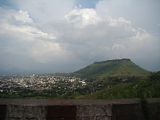
Koregaon is a census town and headquarters for the surrounding Koregaon Taluka in the Satara subdivision of Satara district in the Indian state of Maharashtra. It is situated on the NH-548C Satara-Baitul National Highway about 18 km east of Satara city, about 120 km from Pune and 267 km from Mumbai. The Koregaon railway station, situated on the Pune - Miraj line, is 2 kilometers outside the town. Koregaon Bus Station is conveniently located just a stone's throw away from the railway station.
Bhoite is a surname found amongst the Maratha caste, mainly in the state of Maharashtra in India but it also appears in Indian states bordering Maharashtra.
Tadawale Sammat Wagholi is a small town and gram panchayat in Koregaon taluka, Satara district, in the Indian province of Maharashtra.
Ranoji Bhoite was a Maratha chieftain of the Bhoite clan who lived in the 18th century. The Commander in Chief of the Maratha army from satara He was a contemporary of Ranoji Shinde, Dattaji Shinde, and others. Bhoite was an active Commander in Maratha's North India Campaign. Some Maratha leaders survived after the Panipat battle and created their own kingdoms, but Bhoite did not. He served under King Shahu in the Satara Kingdom.
Hingangaon is a small town and Gram panchayat in Phaltan Tehsil, District Satara of the Indian state of Maharashtra. It is situated in a mountainous region, 6–8 km from the Pune-Pandharpur Highway and Phaltan-Satara Roads mounted on Deccan Plateau.
Walwa is a taluka in Sangli district in the Indian state of Maharashtra. It is also known as Walwa-Islampur Taluka. There are ninety-five panchayat villages in Walwa Taluka.
Khandala is a town and taluka in the Satara district in the Indian state of Maharashtra.
Kudal is a village in the Satara district, Maharashtra, India. It is surrounded by a river called Niranjana or Kudali. There is a big temple of 'Pimpleshwar & Wakadeshwar' at the river coast. Agriculture is the main land use in the village, with more than 75% of the total area being used for agricultural activities. The village has a close view to the historic Vairatgad Fort. It is central for 15 villages situated nearby Kudal Village.
Ratoji Bhoite inamdaar was a Maratha sardar who served Bahamani Sultanates of Deccan. He then joined Chhatrapati Shivaji Bhosales Swarajya Campaign in the 17th century. He was an ancestor of Bhoite families of Tadawale. Ratoji was inamdar of Tadawale and surrounding areas concluding villages of current North Koregaon area. He also had command over Fort Nandgiri (Kalyangad). He started his career as shiledar of Sultanates as his forefathers were. His descendants were to play an important part in Marathas' subsequent history.

Maharashtra is a state in the western region of India. It is India's second-most populous state and third-largest state by area. The region that comprises the state has a long history dating back to approximately 1300–700 BCE, although the present-day state was not established until 1960 CE.
Banawadi is a census village of Satara district in the Indian state of Maharashtra. It is situated near to the Satara Phaltan state highway, about 21 km north of Satara, about 108 km from Pune and 220 km from Mumbai.

Vaduj is a major town in Satara district of Maharashtra, India. It is the headquarters of Khatav Taluka. It is located on the banks of the Yerala River, and is around 58 kilometres (36 mi) away from the district capital Satara, and 165 kilometres (103 mi) away from Pune. It is the biggest town in Khatav Taluka, with a population of around 17,636 people. Recently, its status was changed to Nagar Panchayat.
Garavadi (Ramnagar) is a census village in the Satara district, located in the India state of Maharashtra. There are a total of approximately 240 families residing within its borders. The village is located in the Khatav Tehsil of Satara district in Maharashtra, India. It is 32 km away from the sub-district headquarters of Vaduj, and 54 km away from the district headquarters of Satara. Research from 2009 shows that Garavadi village is also classified as a gram panchayat. According to the India Census in 2011, the village was recorded to have a population of 997, 478 of which were males, and the other 519 females.

Lalgun is a village in Khatav taluka of Satara district in the Indian state of Maharashtra. It is located on Pusegaon-Phaltan State Highway (SH-147) and comes under Koregaon Assembly constituency and Satara Lok Sabha constituency. Lalgun has a population of about 2930.

Wathar also known as Wathar Station is a town in Koregaon taluka of Satara district in the Indian state of Maharashtra. It is located on NH-965D and Pune-Miraj-Londa Railway Line. This town comes under Phaltan Assembly constituency and Madha Lok Sabha constituency. Wathar has a population of about 5393.