Waikaia River

Last updated

Waikaia River
Waikaia in 1955.jpg
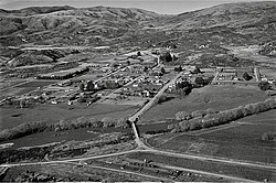
Waikaia and Waikaia River in 1955
Location
Country New Zealand
Physical characteristics
Source 
  locationOld Woman Range
  elevation1,749 metres (5,738 ft)
Mouth  
  location
Mataura River
  elevation
120 metres (390 ft)
Length95 kilometres (59 mi) including Waikaia East River branch
Basin size1,830 square kilometres (710 sq mi)
Discharge 
  average24.41 cubic metres per second (862 cu ft/s)

The Waikaia River [1] is a river in New Zealand, a tributary of the Mataura River. The name is probably a corruption of Wai-o-Whakaea. [2]

The moderate sized Waikaia River rises in swamps and tussock land in the Umbrella Mountains to the east of the headwaters of the Pomahaka River and then flows south for 50 kilometres (31 mi) through rugged native bush-clad hills and then from Piano Flat through farmed areas until it joins the Mataura River at Riversdale. Much of the upper valley is in beech forest. Below Piano Flat the river meanders across a floodplain, much of it irrigated for dairy farming. [3] Total nitrogen concentration in the lower river is 0.47g/m3. [4]

Its tributaries include Gow Burn, Steeple Burn, Dome Burn, Winding Creek and Argyle Burn with the Dome Burn and Steeple Burn being brown trout spawning streams for the Mataura River system.

Nokomai patterned mire, in the upper catchment, is part of a relatively unmodified wetland on several square kilometres of the southern Garvie Mountains. [5] It is possibly the largest such area in Australasia and is dominated by grasses, sedges and mosses, with shallow pools, small islands and clumps of low vegetation. The mire drains south via Dome Burn to the Waikaia and north via Roaring Lion Creek to the Nevis River. [6] A small part of the mire is in the Nokomai catchment. [7]

Highly regarded as a brown trout fishery the quality of the water in its lower reaches deteriorated in the early 21st century due to the conversion of much of the surrounding farmland to intensive dairy farming. [8]

Gold was dredged from beside the river at Freshford (south of Waikaia) [9] until 2019. [10] An application to mine at Winding Creek (east of Waikaia and scene of an 1863 gold rush) [11] was made in 2021. [12] Other mines, mostly also to the east of Waikaia, have worked gold derived from Cretaceous orogenic deposits in Mesozoic Otago Schist. It was eroded out of the Old Man Range / Kopuwai, after it started rising in the Miocene period, and was then washed out to the alluvial flats. [13] By 1909 the area had 16 dredges working. [14]

See also

Related Research Articles

<span class="mw-page-title-main">Ahaura River</span> River in the South Island of New Zealand

The Ahaura River is in the South Island of New Zealand. This river drains the western flanks of the Southern Alps and flows into the Grey River.

<span class="mw-page-title-main">Awarau River</span> River in New Zealand

The Awarau River, usually known as Larry's Creek is located within the South Island of New Zealand. The river is about 27 kilometres (17 mi) long and runs northwest from its headwaters in the Victoria Range to its confluence with the Inangahua River north of Reefton. It also drains part of the Brunner Range and there was a track along that range linking to Lyell by 1901, though none existed in 1874. A track also ran south over Kirwan Hill to the Montgomerie River.

<span class="mw-page-title-main">Buller River</span> River in New Zealand

The Buller River is a river in the South Island of New Zealand. The Buller has the highest flow of any river in the country during floods, though it is only the 13th longest river; it runs for 177 km (110 mi) from Lake Rotoiti through the Buller Gorge and into the Tasman Sea near the town of Westport. A saddle at 710 m (2,330 ft) separates the Buller from the Motupiko River and that is divided from the Wairau River by a 695 m (2,280 ft) saddle, both aligned along the Alpine Fault, as is the top of the Buller valley.

<span class="mw-page-title-main">Nevis River</span> River in New Zealand

The Nevis River is in Otago, New Zealand. It flows north for 40 kilometres (25 mi) through rough country before meeting the Kawarau River, of which it is a tributary. A prominent rock outcrop close to this junction is known as the Nevis Bluff.

<span class="mw-page-title-main">Ohikanui River</span> River in New Zealand

The Ōhikanui River is a tributary of the Buller River in New Zealand's South Island. It flows north for 30 km (19 mi), joining the Buller 20 km (12 mi) from its outflow into the Tasman Sea. It and its smaller neighbour the Ohikaiti River are often called the Big Ohika River and Little Ohika River respectively. Another variation is Ohika-nui. Ōhikanui River has been the official name since 21 June 2019.

<span class="mw-page-title-main">Waihou River</span> River in Waikato, New Zealand

The Waihou River is located in the northern North Island of New Zealand. Its former name, Thames River, was bestowed by Captain James Cook in November 1769, when he explored 14 mi (23 km) of the river from the mouth. An older Māori name was "Wai Kahou Rounga". A 1947 Geographic Board enquiry ruled that the official name would be Waihou.

<span class="mw-page-title-main">Whakapapa River</span> River in Manawatū-Whanganui, New Zealand

The Whakapapa River in New Zealand forms from streams which trickle off the Whakapapa skifield of Mount Ruapehu and down the western slopes of the mountain. The river passes near Ōwhango, before finally merging with the Whanganui River just east of Kakahi, about 40 km (25 mi) from where it starts, which is in a 100 m (330 ft) deep gorge, at the confluence of the Whakapapaiti and Whakapapanui Streams.

<span class="mw-page-title-main">Waikaia Branch</span> Closed South Island railway branch line

The Waikaia Branch, also known as the Switzers Branch, was a branch line railway in Southland, New Zealand. Proposed as early as the 1870s, it was not opened until 1909 and was operated by the New Zealand Railways Department for half a century until its closure in 1959.

<span class="mw-page-title-main">Stillwater–Ngākawau Line</span> Railway line in New Zealand

The Stillwater Ngākawau Line (SNL), formerly the Stillwater–Westport Line (SWL) and the Ngakawau Branch, is a secondary main line, part of New Zealand's national rail network. It runs between Stillwater and Ngakawau via Westport on the West Coast of the South Island. It was one of the longest construction projects in New Zealand's history, with its first section, at the south end, opened in 1889, and the beginnings of the Ngākawau Branch, at its Westport end, in 1875. The full line was completed in 1942. The only slower railway projects were Palmerston North to Gisborne, 1872 to 1942, and the Main North Line to Picton, 1872 to 1945.

<span class="mw-page-title-main">Athol, New Zealand</span> Place in South Island, New Zealand

Athol is a small town in Southland, New Zealand. It is located on State Highway 6, 55 km south of Queenstown, halfway between Lumsden and Kingston on the Southern Scenic Route. Farming has always been very important in the district, though in earlier times gold mining, centred on nearby Nokomai, was also significant. In recent decades tourist numbers have grown. The Mataura River is well known for the quality of its brown trout fishing, and the Around the Mountains Cycle Trail, opened in November 2014, has further boosted visitor figures.

<span class="mw-page-title-main">Seddonville</span> Place in West Coast, New Zealand

Seddonville is a lightly populated locality on the West Coast of New Zealand's South Island. It is most famous for the historical role it played in New Zealand's coal mining industry.

Fortification is a locality in the western part of the Catlins region of Southland in New Zealand's South Island. Nearby settlements include Quarry Hills and Waikawa to the southeast, Tokanui to the southwest, and Waimahaka to the west. It is over 50 km east of Southland's main centre, Invercargill.

<span class="mw-page-title-main">Big River (Southland)</span> River in New Zealand

The Big River has also been known by several other names, Windsor River and Māori name Okopowa, Patu-po, or Patupō, though that last name, meaning kill by night, might refer to a place near Long Point and Waitutu. It is a river of southern Fiordland, New Zealand, and is one of three rivers of that name in the South Island. It is the main source of Lake Hakapoua and a lower stretch is the lake's 2-kilometre (1.2 mi) outflow to the sea. The river rises on the 1,123 m (3,684 ft) high Arnett Peak, in the Cameron Mountains, runs about 23 km (14 mi) to the lake. At about the mid point of the river it runs through a narrow gorge. Elsewhere it is generally very shallow. The river is in the Fiordland National Park.

<span class="mw-page-title-main">Manaia River</span> River in New Zealand

The Manaia River is a river of the Coromandel Peninsula in New Zealand's North Island. It flows north from its sources in the Coromandel Range, reaching the Hauraki Gulf at Manaia Harbour, 10 kilometres (6 mi) southwest of Coromandel.

<span class="mw-page-title-main">Tapu River</span> River in New Zealand

The Tapu River is a river of the Coromandel Peninsula in New Zealand's North Island. It flows west from the Coromandel Range, reaching the Firth of Thames at the settlement of Tapu, approximately halfway between Thames and Coromandel.

<span class="mw-page-title-main">Te Mata River</span> River in New Zealand

The Te Mata River is a river of the Coromandel Peninsula in New Zealand's North Island. It flows west to reach the Firth of Thames at the small settlement of Te Mata, 25 kilometres (16 mi) south of Coromandel.

<span class="mw-page-title-main">Otautau</span> Place in Southland region, New Zealand

Otautau is a small farming, forestry and milling town located inland on the western edge of the Southland Plains of New Zealand on the banks of the Aparima River. Otautau is located approximately 40 kilometres (25 mi) north west of Invercargill. The average elevation of Otautau is 60 meters.

The Mangatangi River, or Mangatangi Stream, originates on the eastern slopes of the Hunua Ranges in New Zealand and flows roughly southwards until it is joined by the Ruaotehuia Stream just north of State Highway 2 between Mangatawhiri and Maramarua, where it becomes the Maramarua River. Mangatangi can be translated as manga tangi to stream of weeping, or as rippling stream, or babbling brook.

<span class="mw-page-title-main">Lake Hakanoa</span> Riverine in North Island

Lake Hakanoa is located within the eastern side of the Huntly township, in the Waikato Region of New Zealand. Lake Hakanoa is a riverine lake with links to the Waikato River, which lies 300 m (330 yd) to the west. A smaller lake lies within wetland near the southeastern edge of Hakanoa.

<span class="mw-page-title-main">Newton River (Buller River tributary)</span> River in New Zealand

Newton River in the Tasman District ), flows west and then south for about 20 km (12 mi) from Mount Newton to the Buller River, 17 km (11 mi) west of Murchison. Near its mouth it is crossed by SH6 on a steel truss bridge with a 120 ft (37 m) main span and two 30 ft (9.1 m) side spans.

References

  1. "Place name detail: Waikaia River". New Zealand Gazetteer. New Zealand Geographic Board . Retrieved 12 July 2009.
  2. "Waikaia River". gazetteer.linz.govt.nz. Retrieved 24 July 2023.
  3. "Waikaia Surface Water Zone Water Quantity Data". Land, Air, Water Aotearoa (LAWA). Retrieved 24 July 2023.
  4. "Mataura Catchment Strategic Water Study" (PDF). Environment Southland. May 2011.
  5. "DOC wants to seek international recognition for Taieri Scroll Plain". www.doc.govt.nz. 6 August 2013. Retrieved 23 July 2023.
  6. A. F. Mark , P. N. Johnson , K. J. M. Dickinson & M. S. McGlone (March 1995). "Southern hemisphere patterned mires, with emphasis on southern New Zealand".{{cite web}}: CS1 maint: multiple names: authors list (link)
  7. "Mount Tennyson, Southland". NZ Topo Map. Retrieved 23 July 2023.
  8. Kent, John: “South Island Trout Fishing Guide”. Page 346. Penguin Books, Auckland (2009). ISBN   978-0-14-320268-4.
  9. "Freshford, Southland". NZ Topo Map. Retrieved 24 July 2023.
  10. Kelly, Rachael (2 April 2019). "Waikaia Gold finishes mining operations at Freshford in Northern Southland". Stuff. Retrieved 24 July 2023.
  11. "SWITZER'S THREE NEW RUSHES. Lake Wakatip Mail". paperspast.natlib.govt.nz. 26 August 1863. Retrieved 24 July 2023.
  12. Hooper, Laura (3 August 2021). "Company has plans for new gold mine near Waikaia". Stuff. Retrieved 24 July 2023.
  13. McLachlan, Christine; Negrini, Marianne; Craw, Dave (3 April 2018). "Gold and associated minerals in the Waikaia placer gold mine, Northern Southland, New Zealand". New Zealand Journal of Geology and Geophysics. 61 (2): 164–179. doi:10.1080/00288306.2018.1454482. ISSN   0028-8306.
  14. "THE GOLDFIELDS OF NEW ZEALAND (REPORT ON)". paperspast.natlib.govt.nz. 1909. Retrieved 24 July 2023.

45°53′S168°48′E / 45.883°S 168.800°E / -45.883; 168.800