Taranaki is a region in the west of New Zealand's North Island. It is named after its main geographical feature, the stratovolcano of Mount Taranaki, also known as Mount Egmont.
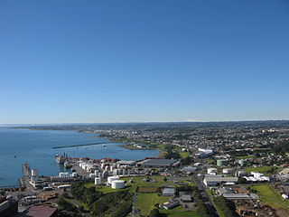
New Plymouth is the major city of the Taranaki Region on the west coast of the North Island of New Zealand. It is named after the English city of Plymouth, Devon from where the first English settlers to New Plymouth migrated. The New Plymouth District, which includes New Plymouth City and several smaller towns, is the 10th largest district in New Zealand, and has a population of 86,100 – about two-thirds of the total population of the Taranaki Region and 1.7% of New Zealand's population. This includes New Plymouth City (57,600), Waitara (7,270), Inglewood (3,750), Ōakura (1,650), Ōkato (561) and Urenui (429).

Mount Taranaki or Taranaki Maunga, also known as Mount Egmont, is a dormant stratovolcano in the Taranaki region on the west coast of New Zealand's North Island. It is the second highest point in the North Island, after Mount Ruapehu. The 2518-metre (8260-foot) mountain has a secondary cone, Fanthams Peak, 1,966 metres (6,450 ft), on its south side.

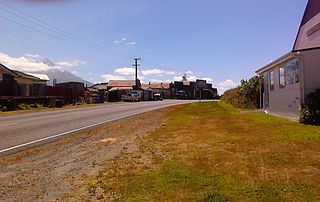
Inglewood is a town in the Taranaki Region of New Zealand's North Island. It is 16 kilometres (10 mi) southeast of New Plymouth on State Highway 3, close to Mount Taranaki, and sits 200 metres (660 ft) above sea level. The town services a mainly dairy farming region.

Ōkato is a small town in rural Taranaki, New Zealand. It is situated about 25 minutes drive around the coast from New Plymouth on State Highway 45. Oakura is 12 km to the north-east, and Warea is 9 km to the south-west. The place offers popular rocky surfing spots around coastal beaches. The town was established as a military settlement in the 1860s.
Richard "Dicky" Barrett (1807–1847) was one of the first European traders to be based in New Zealand. He lent his translation skills to help negotiate the first land purchases from Maori in New Plymouth and Wellington and became a key figure in the establishment of the settlement of New Plymouth. He was described by Edward Jerningham Wakefield, son of New Zealand Company founder Edward Gibbon Wakefield, as short, stout and "perfectly round all over" and fond of relating "wild adventures and hairbreadth 'scapes".

Ngaere is a village situated on State Highway 3, 4 kilometres (2.5 mi) south of Stratford, New Zealand. The name "Ngaere" literally means "swamp" in English, and before settlement, the area was covered by a vast and ancient wetland.
Midhirst is a small village in Taranaki, New Zealand, approximately 4 km north of Stratford, on State Highway 3. Inglewood is 17 km (11 mi) north of Midhirst, and New Plymouth is 35 km (22 mi) to the northwest.

Ōakura is a small township in New Plymouth District, Taranaki, in the western North Island of New Zealand. It is located on State Highway 45, 15 kilometres south-west of New Plymouth. Ōkato is 12 km further south-west. The Oakura River flows past the town and into the North Taranaki Bight. To the south is the Kaitake Range, part of Egmont National Park.

Moturoa is a coastal suburb of New Plymouth, in the western North Island of New Zealand. It is located to the west of the city centre, bordering Port Taranaki and The Sugar Loaf Islands. One of the islands, Moturoa, the largest, shares its name with the suburb.
Alton is a small rural community in south Taranaki, in the western North Island of New Zealand. It is located between the towns of Hāwera and Patea.
Cardiff is a settlement in inland Taranaki, in the western North Island of New Zealand. It is located five kilometres southwest of Stratford close to Egmont National Park.
Te Popo is a settlement in inland Taranaki, in the western North Island of New Zealand. It is located ten kilometres northeast of Stratford.

Onaero is a settlement in northern Taranaki, in the North Island of New Zealand. It is located on State Highway 3 close to the shore of the North Taranaki Bight, 15 kilometres (9.3 mi) east of Waitara. Onaero was the site of the No. 2 Company Redoubt, a British military installation created during the Second Taranaki War by soldiers from the Tikorangi Redoubt in 1865, however it was abandoned several months later.
Tongapōrutu is a settlement in northern Taranaki, in the North Island of New Zealand. It is located on State Highway 3 at the mouth of the Tongaporutu River, 15 kilometres south of Mokau. Tongapōrutu is well known in New Zealand for its 'Three Sisters' rock formations and its Māori petroglyphs carved into cave rock walls. However, both the Māori rock carvings and the 'Three Sisters formations are constantly being eroded by the Tasman Sea.
Awakino is a settlement in the south of Waitomo District, in the North Island of New Zealand. It is located on State Highway 3 at the mouth of the Awakino River, five kilometres north of Mokau. It is 79 km southwest of Te Kuiti, and 98 km northeast of New Plymouth.

The Sugar Loaf Islands are a collection of five small uninhabited islands and several sea stacks near Port Taranaki, Taranaki, New Zealand.

Brooklands is a suburb of New Plymouth, in the Taranaki region of the western North Island of New Zealand. It is located on the southern edge of the city and east of Vogeltown. The area is named after Brooklands farm, established in 1842.

Puke Ariki is a combined museum and library at New Plymouth, New Zealand which opened in June 2003. It is an amalgamation of the New Plymouth Public Library and the Taranaki Museum. Its name, Māori for "hill of chiefs", is taken from the Māori village that formerly occupied the site.

Pukekura Park is a Garden of National Significance, covering 52ha near the heart of New Plymouth, Taranaki in New Zealand.