Related Research Articles

The West Coast is a region of New Zealand on the west coast of the South Island that is administered by the West Coast Regional Council. It comprises the territorial authorities of Buller District, Grey District and Westland District. The principal towns are Westport, Greymouth, and Hokitika. The region is one of the more remote and most sparsely populated areas of the country.
Blackwater River is the name of three rivers in the northwestern South Island of New Zealand, one flowing into the Mangles River, one into the Buller River between Westport and Inangahua Junction, and one into the Māwheraiti River. All three rivers are within a few kilometres of each other, to the south and east of Westport.

Haupapa / Tasman Glacier is the largest glacier in New Zealand, and one of several large glaciers which flow south and east towards the Mackenzie Basin from the Southern Alps in New Zealand's South Island.
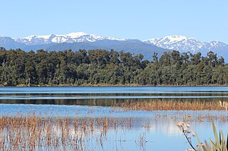
Ōkārito Lagoon is a coastal lagoon on the West Coast of New Zealand's South Island. It is located 130 kilometres (81 mi) south of Hokitika, and covers an area of about 3,240 hectares (12.5 sq mi), making it the largest unmodified coastal wetland in New Zealand. It preserves a sequence of vegetation types from mature rimu forest through mānuka scrub to brackish water that has been lost in much of the rest of the West Coast. Ōkārito Lagoon is the main feeding ground for New Zealand's only breeding population of rare white heron. The settlement of Ōkārito is at the southern end of the lagoon.

Lake Kaniere is a glacial lake located on the West Coast of New Zealand's South Island, nearly 200 m deep and surrounded on three sides by mountains and mature rimu forest. It is regarded by many as the most beautiful of the West Coast lakes, and is a popular tourist and leisure destination.

The Tasman River is an alpine braided river flowing through Canterbury, in New Zealand's South Island.

Te Hoiere / Pelorus River is a river at the northern end of South Island of New Zealand in the region of Marlborough. It flows from the Richmond Range into Pelorus Sound. This area is fantastic for camping and is renowned for its magnificent river swimming where the Pelorus River runs through a gorge at Pelorus Bridge.
Lake Mahinapua is a shallow lake on the West Coast of New Zealand's South Island. Once a lagoon at the mouth of the Hokitika River, it became a lake when the river shifted its course. Lake Māhinapua was the site of a significant battle between Ngāi Tahu and Ngāti Wairangi Māori, and is regarded by them as a sacred site where swimming and fishing are prohibited. In European times it was part of an inland waterway that carried timber and settlers between Hokitika and Ross until the building of the railway. Today it is protected as a scenic reserve for boating, camping, and hiking.

The Whataroa River, sometimes the Wataroa River, is a river in the southern West Coast region of New Zealand's South Island. Its source is in the Southern Alps and it flows north and northwest, passing the township of Whataroa on the eastern side before reaching the Tasman Sea just south of Abut Head. The river is fed by many tributaries, such as the Perth River, and is crossed by State Highway 6 on its route between Whataroa and Te Taho.
The Ōkārito River is a river of the West Coast Region of New Zealand's South Island. It flows northwest from the northern end of Lake Mapourika, reaching the Ōkārito Lagoon 15 kilometres west of Whataroa.

The Opotoru River is a river of the Waikato Region of New Zealand's North Island. It flows north, reaching the Raglan Harbour southwest of the town of Raglan. There is no regular monitoring of pollution, but 38 kilometres (24 mi) (31.2%) of the river has been fenced to protect it from farm stock.

The Waiho River is a river of the West Coast region of New Zealand's South Island. It is fed by the meltwater of the Franz Josef Glacier and skirts the main township of Franz Josef to its south, where its river bed is crossed by SH 6 on a long single-lane bridge. Due to changes in rainfall and snow melt, the river's water flow varies greatly. In a severe rain storm on 26 March 2019, the bridge was destroyed after 400 millimetres (16 in) of rain had fallen. The bridge and one abutment was rebuilt, and the road link reopened after 18 days. The works cost NZ$6m.
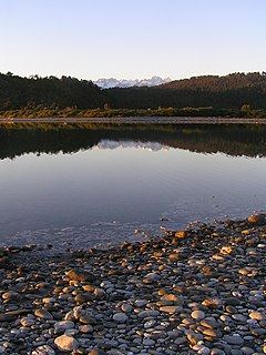
The Waitangiroto River is a river of the West Coast Region of New Zealand's South Island. It flows northwest from its origins north of Whataroa to reach the Tasman Sea two kilometres north of the Okarito Lagoon. The lower reaches of the longer Waitangitaona River follow a roughly parallel course one kilometre to the north. Both rivers are linked to the Whataroa River, which reaches the Tasman three kilometres to the north of the Waitangiroto's mouth.

Bruce Bay is a bay and settlement in South Westland, New Zealand on the Tasman Sea. It is located on State Highway 6, 74 kilometres (46 mi) northwest of Haast and 45 kilometres (28 mi) southwest of Fox Glacier. The small settlement of Bruce Bay is located just south of the mouth of Mahitahi River. The bay is a nesting ground for the Fiordland crested penguin, and endemic Hector's dolphins and southern right whales can be observed from the shore on occasion. Some of the bush around the bay has been cleared for farming, and quartz stones can be found on the beach.
The Waingaro River is a river of the Tasman Region of New Zealand's South Island.
Ōkārito is a small coastal settlement on the West Coast of New Zealand's South Island, 130 kilometres (81 mi) south of Hokitika. It is built at the southern end of the Ōkārito Lagoon at the mouth of the Ōkārito River. The settlement of The Forks is located just inland, on the banks of the river.

Te Awa-o-Tū / Thompson Sound is a fiord of the South Island of New Zealand. It is one of the fiords that form the coast of Fiordland.
Taiporoporo / Charles Sound is a fiord of the South Island of New Zealand. It is one of the fiords that form the coast of Fiordland.
Taitetimu / Caswell Sound is a fiord of the South Island of New Zealand. It is one of the fiords that form the coast of Fiordland.
Te Houhou / George Sound is a fiord of the South Island of New Zealand. It is one of the fiords that form the coast of Fiordland.
References
"Place name detail: Waitangitaona River". New Zealand Gazetteer. Land Information New Zealand . Retrieved 12 July 2009.
- ↑ "Change to correct Te Reo spelling for river". Green Party of Aotearoa New Zealand. 20 December 2018. Retrieved 28 January 2019.
- 1 2 3 4 "Report on proposals for: Waitangitāhuna River [altered from Waitangitaona River (recorded name)] Waitakitāhuna-ki-te-Toka [altered from Waitangitaona River (recorded name)]" (PDF). LINZ. 16 October 2016.
- ↑ "Waitangitaona River, West Coast". NZ Topo Map. Retrieved 28 January 2019.
- ↑ "Wahapo Power Station - Okarito Forks - Lake Wahapo - Trustpower". www.trustpower.co.nz. Retrieved 28 January 2019.
- ↑ "Waitangitaona River, West Coast". NZ Topo Map. Retrieved 28 January 2019.
- ↑ "Waitangitaona River, West Coast". NZ Topo Map. Retrieved 28 January 2019.
| This article about a river in the West Coast, New Zealand is a stub. You can help Wikipedia by expanding it. |