
Google Maps is a web mapping platform and consumer application offered by Google. It offers satellite imagery, aerial photography, street maps, 360° interactive panoramic views of streets, real-time traffic conditions, and route planning for traveling by foot, car, bike, air and public transportation. As of 2020, Google Maps was being used by over 1 billion people every month around the world.
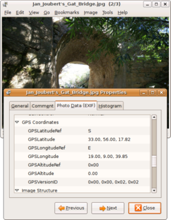
Geotagging, or GeoTagging, is the process of adding geographical identification metadata to various media such as a geotagged photograph or video, websites, SMS messages, QR Codes or RSS feeds and is a form of geospatial metadata. This data usually consists of latitude and longitude coordinates, though they can also include altitude, bearing, distance, accuracy data, and place names, and perhaps a time stamp.

OpenStreetMap (OSM) is a collaborative project to create a free editable geographic database of the world. The geodata underlying the maps is considered the primary output of the project. The creation and growth of OSM has been motivated by restrictions on use or availability of map data across much of the world, and the advent of inexpensive portable satellite navigation devices.

A point of interest (POI) is a specific point location that someone may find useful or interesting. An example is a point on the Earth representing the location of the Eiffel Tower, or a point on Mars representing the location of its highest mountain, Olympus Mons. Most consumers use the term when referring to hotels, campsites, fuel stations or any other categories used in modern automotive navigation systems.

Android 13 is the thirteenth major release of the Android mobile operating system, developed by the Open Handset Alliance led by Google, released for the public on August 15, 2022.
Global Navigation Satellite System (GNSS) receivers, using the GPS, GLONASS, Galileo or BeiDou system, are used in many applications. The first systems were developed in the 20th century, mainly to help military personnel find their way, but location awareness soon found many civilian applications.
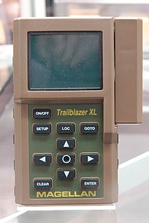
A satellite navigation device is a user equipment that uses one or more of several global navigation satellite systems (GNSS) to calculate the device's geographical position and provide navigational advice. Depending on the software used, the satnav device may display the position on a map, as geographic coordinates, or may offer routing directions.

HERE Technologies is an American-Dutch multinational group dealing with mapping, location data and related automotive services to individuals and companies. It is majority-owned by a consortium of German automotive companies and American semiconductor company Intel whilst other companies also own minority stakes. Its roots date back to U.S.-based Navteq in 1985, which was acquired by Finland-based Nokia in 2007. HERE is currently based in The Netherlands.
Google Maps Navigation is a mobile application developed by Google for the Android and iOS operating systems that was later integrated into the Google Maps mobile app. The application uses an Internet connection to a GPS navigation system to provide turn-by-turn voice-guided instructions on how to arrive at a given destination. The application requires connection to Internet data and normally uses a GPS satellite connection to determine its location. A user can enter a destination into the application, which will plot a path to it. The app displays the user's progress along the route and issues instructions for each turn.

Sygic is a Slovak company of global automotive navigation systems for mobile phones and tablets. The company was founded in 2004 and is headquartered in Bratislava, Slovakia. It became the first company to offer navigation for iPhone and second for Android. In 2015 Sygic reached milestone of 100 million downloads of its navigation app.
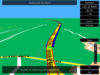
Turn-by-turn Navigation is a feature of some satellite navigation devices where directions for a selected route are continually presented to the user in the form of spoken or visual instructions. The system keeps the user up-to-date about the best route to the destination, and is often updated according to changing factors such as traffic and road conditions. Turn-by-turn systems typically use an electronic voice to inform the user whether to turn left or right, the street name, and the distance to the next turn.

OsmAnd is a map and navigation app for Android and iOS. It uses the OpenStreetMap (OSM) map database for its primary displays, but is an independent app not endorsed by the OpenStreetMap Foundation. It is available in both free and paid versions; the latter unlocks the download limit for offline maps and provides access to Wikipedia points of interest (POIs) and their descriptions from within the app. Map data can be stored on the device for offline use. Using the device's GPS capabilities, OsmAnd offers routing, with visual and voice guidance, for car, bike, and pedestrian. All of the main functionalities work both online and offline.

Kinomap is a complete end-to-end platform for creating, hosting, sharing and using motion videos for user-generated videos. Kinomap allows uploading motion videos shot with a GPS camera or a common camera coupled with GPS track from another device. Kinomap platform contains geolocated video shooting, applications for Smartphone and tablets, data acquisition and integration, dedicated web portals and features like round-tour management, audio and video navigation, video tourism, indoor fitness training etc.

MyTracks was a Global Positioning System (GPS) tracking application that ran on Android. The application used a device's GPS capabilities to collect data, allowing real-time review of path, speed, distance, and elevation. Later, this data could be saved to Google Maps, Google Fusion Tables, or Google Docs and shared with Google+, Facebook, or Twitter. The application also allowed a user to record annotations along the path, hear periodic voice announcements of progress, and sync with select third-party bio-metric sensors.
This article contains a list with gratis satellite navigation software for a range of devices. Some of the free software mentioned here does not have detailed maps or the ability to follow streets or type in street names. However, in many cases, it is also that which makes the program free, avoid the need of an Internet connection, and make it very lightweight. Very basic programs like this may not be suitable for road navigation in cars, but serve their purpose for navigation while walking or trekking, and for use at sea. To determine the GPS coordinates of a destination, one can use sites such as GPScoordinates.eu and GPS visualizer.

Wikiloc is a premium website, launched in 2006, containing GPS trails and waypoints that members have uploaded. This mashup shows the routes in frames showing Google Maps. The service is also available in Google Earth. There are mobile apps for Android and iPhone. The product has more than 4.5M members, is offered in many languages and has more than 11.6M tracks of dozens of activities in many countries and territories. Wikiloc began as a worldwide online reference for hiking. Additionally, photographs on Wikiloc enabled automated content analysis to characterize the landscape in the Ebro Delta Natural Park, Spain.
HERE WeGo is a web mapping and navigation service, operated by HERE Technologies and originally developed by Nokia. In 2013, HERE Technologies released this web mapping application for Windows Phone and the World Wide Web as a revamped version of Nokia Maps. HERE Technologies released the HERE Maps application to the Android platform on December 10, 2014 and later for iOS on March 11, 2015. The company changed the product name to HERE WeGo in July 2016. It is the default maps service provider for the Amazon Fire tablets and smartphone.

Locus Map is a multi-functional Android navigation app adding advanced online and offline GPS capabilities to Android devices. Primarily it is designed and used for leisure time outdoor activities like hiking, biking, geocaching. Besides its leisure time utilization the app is also used by professionals e.g. for collecting geospatial data, by rescue squad teams, aerial reconnaissance teams etc.
MapmyIndia is an Indian technology company that builds digital map data, telematics services, location-based SaaS and GIS AI technologies. The company was founded in 1995 and is headquartered at New Delhi with regional offices in Mumbai and Bengaluru and smaller offices across India. It also has international offices in the San Francisco Bay Area and Tokyo.
Organic Maps is an open-source mobile map and navigation app with a focus on privacy. This app is similar to OsmAnd and has the usual routes, cycling lanes and elevation and features that are commonly present in other mapping apps sourcing map data from OpenStreetMap.