Saarland is a state of Germany in the west of the country. With an area of 2,570 km2 (990 sq mi) and population of 995,600 in 2015, it is the smallest German state in both area and population apart from the city-states of Berlin, Bremen, and Hamburg. Saarbrücken is the state capital and largest city; other cities include Neunkirchen and Saarlouis. Saarland is mainly surrounded by the department of Moselle in France to the west and south and the neighboring state of Rhineland-Palatinate in Germany to the north and east; it also shares a small border about 8 kilometres long with the canton of Remich in Luxembourg to the northwest.
The Palatinate, historically also Rhenish Palatinate or Lower Palatinate (Unterpfalz), is a region in southwestern Germany. It occupies roughly the southernmost quarter of the German federal state of Rhineland-Palatinate (Rheinland-Pfalz), covering an area of 5,451 square kilometres (2,105 sq mi) with about 1.4 million inhabitants. Its residents are known as Palatines.
The Rhineland is the name used for a loosely defined area of Western Germany along the Rhine, chiefly its middle section.
Moselle is the most populous department in Lorraine, in the east of France, and is named after the river Moselle, a tributary of the Rhine, which flows through the western part of the department. Inhabitants of the department are known as Mosellans.

Saarbrücken is the capital and largest city of the state of Saarland, Germany. Saarbrücken is Saarland's administrative, commercial and cultural centre and is next to the French border.
Saarlouis is a Kreis (district) in the middle of the Saarland, Germany. Neighboring districts are Merzig-Wadern, Sankt Wendel, Neunkirchen, Saarbrücken, and the French département Moselle.

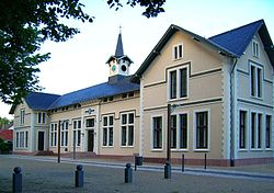
Saarlouis is a town in Saarland, Germany, capital of the district of Saarlouis. In 2017, the town had a population of 34,758. Saarlouis, as the name implies, is located on the river Saar. It was built as a fortress in 1680 and was named after Louis XIV of France.
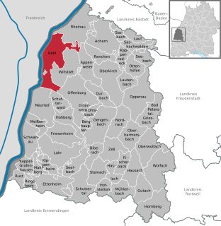
Kehl is a town in southwestern Germany in the Ortenaukreis, Baden-Württemberg. It is located on the river Rhine, directly opposite the French city of Strasbourg.

The Rhine Province, also known as Rhenish Prussia (Rheinpreußen) or synonymous with the Rhineland (Rheinland), was the westernmost province of the Kingdom of Prussia and the Free State of Prussia, within the German Reich, from 1822 to 1946. It was created from the provinces of the Lower Rhine and Jülich-Cleves-Berg. Its capital was Koblenz and in 1939 it had 8 million inhabitants. The Province of Hohenzollern was militarily associated with the Oberpräsident of the Rhine Province.
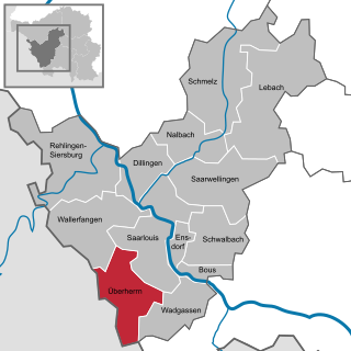
Überherrn is a municipality in the district of Saarlouis, in Saarland, Germany. It is situated along the river Bist on the border with France, approx. 10 km (6.21 mi) southwest of Saarlouis, and 20 km (12.43 mi) west of Saarbrücken. It has 12,150 inhabitants. At the part Felsberg-Berus, there is the Longwave transmitter Europe 1.

Dillingen is a town in the district of Saarlouis, in Saarland. It has about 20,000 inhabitants and is divided into the three districts Dillingen-city center, Pachten and Diefflen. The city is located on the edge of the Saar-Hunsrück Nature Park at the mouth of the Prims in the Saar and is located about 10 km from the French border. Dillingen is located about 60 km from Luxembourg City and Trier, 50 km from Metz and 30 km from Saarbrücken and is directly adjacent to the urban area of Saarlouis. In terms of population, it is the second largest municipality in the district of Saarlouis. The Dillinger Hütte steelworks is located here.

Rehlingen-Siersburg is a municipality in the district of Saarlouis, in Saarland, Germany. It is situated on the river Saar, approx. 8 km northwest of Saarlouis, and 30 km northwest of Saarbrücken.

Schmelz is a municipality in the district of Saarlouis, in Saarland, Germany. It is situated approximately 15 km northeast of Saarlouis, and 25 km northwest of Saarbrücken.

Püttlingen is a town in Saarland, Germany, 10 km northwest of Saarbrücken.

Nohfelden is a municipality in the district of Sankt Wendel, in Saarland, Germany. It is situated approximately 15 kilometres (9.3 mi) north of Sankt Wendel, and 20 kilometres (12 mi) southwest of Idar-Oberstein. It was formed during administrative reform in January 1974 from the merger of 13 previously independent municipalities.

The Territory of the Saar Basin was a region of Germany occupied and governed by the United Kingdom and France from 1920 to 1935 under a League of Nations mandate. It had its own flag : a blue, white, and black horizontal tricolour. The blue and white stood for Bavaria, and white and black for Prussia, out of whose lands the Saar Territory was formed. Initially, the occupation was under the auspices of the Treaty of Versailles. Its population in 1933 was 812,000, and its capital was Saarbrücken. The territory closely corresponds with the modern German state of Saarland, but was slightly smaller in area. After a plebiscite was held in 1935, it was returned to Germany.
The territorial changes of Germany include all changes in the borders and territory of Germany from its formation in 1871 to the present. Modern Germany was formed in 1871 when Otto von Bismarck unified most of the German states, with the notable exception of Austria, into the German Empire. After the First World War, Germany lost about 10% of its territory to its neighbours and the Weimar Republic was formed. This republic included territories to the east of today's German borders.
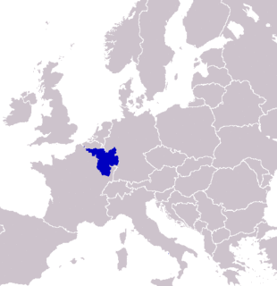
SaarLorLux or Saar-Lor-Lux, a portmanteau of Saarland, Lorraine and Luxembourg, is a euroregion of five regional authorities located in four European states. The term has also been applied to cooperations of several of these authorities or of their subdivisions, administrations, organisations, clubs and people. Member regions represent different political structures: the sovereign state of Luxembourg; Belgium's Walloon region, comprising the French and German speaking parts of Belgium; Lorraine, a region of France; the French départements Moselle and Meurthe-et-Moselle; and the German federated states of Saarland and Rhineland-Palatinate.
The flag of Saarland is based on the flag of Germany and is a black, red, and gold (yellow) horizontal tricolor. In the center of the flag is the coat of arms of Saarland. The flag of Saarland is both the civil flag (Landesflagge), as well as the state service flag (Landesdienstflagge).
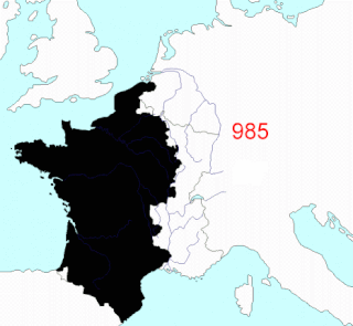
This article describes the process by which the territorial extent of metropolitan France came to be as it is since 1947. The territory of the French State is spread throughout the world. Metropolitan France is that part which is in Europe.