Basel, also known as Basle, is a city in northwestern Switzerland on the river Rhine. Basel is Switzerland's third-most-populous city, with 177,595 inhabitants within the city municipality limits. The official language of Basel is German, and the main spoken language is the local Basel German dialect.

Basel-Stadt or Basel-City is one of the 26 cantons forming the Swiss Confederation. It is composed of three municipalities with Basel as the capital. It is traditionally considered a "half-canton", the other half being Basel-Landschaft, its rural counterpart.

The Battle of St. Jakob an der Birs was fought between the Old Swiss Confederacy and French mercenaries, on the banks of the river Birs. The battle took place on 26 August 1444 and was part of the Old Zürich War. The site of the battle was near Münchenstein, Switzerland, just over 1 km outside the city walls of Basel, today within Basel's St-Alban district.

Andernach is a town in the district of Mayen-Koblenz, in Rhineland-Palatinate, Germany, of about 30,000 inhabitants. It is situated towards the end of the Neuwied basin on the left bank of the Rhine between the former tiny fishing village of Fornich in the north and the mouth of the small river Nette in the southeast, just 13 miles (21 km) north of Koblenz, with its five external town districts: Kell, Miesenheim, Eich, Namedy, and Bad Tönisstein.

Sankt Goar is a town on the west bank of the Middle Rhine in the Rhein-Hunsrück-Kreis (district) in Rhineland-Palatinate, Germany. It belongs to the Verbandsgemeinde Hunsrück-Mittelrhein, whose seat is in Emmelshausen.
Between the 12th century and modern times, the Swiss city of Basel has been home to three Jewish communities. The medieval community thrived at first but ended violently with the Basel massacre of 1349. As with many of the violent anti-Judaic events of the time, it was linked to the outbreak of the Black Death. At the end of the 14th century, a second community formed. But it was short-lived and disbanded before the turn of the century. For the following 400 years, there was no Jewish community in Basel. Today, there are several communities, ranging from liberal to religious to orthodox, and there are still more Jews who don’t belong to any community.

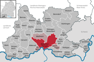
Waldshut-Tiengen, commonly known as Waldshut, is a city in southwestern Baden-Württemberg right at the Swiss border. It is the district seat and at the same time the biggest city in Waldshut district and a "middle centre" in the area of the "high centre" Lörrach/Weil am Rhein to whose middle area most towns and communities in Waldshut district belong. There are furthermore complexities arising from cross-border traffic between this area and the Swiss cantons of Aargau, Schaffhausen and Zürich. This classification relates to Walter Christaller's Central Place Theory, however, and not to any official administrative scheme.
Baselland Transport AG (BLT) is a Swiss public transport operator in the cantons of Basel-Land, Basel-Stadt, Solothurn and in France. The BLT was founded in 1974, and is owned by the Canton of Basel-Land, located to the south of the city. It transports some 48 million passengers per year, using a fleet of 64 buses and 100 trams over a network of 165 kilometres (103 mi) of bus routes and 65 kilometres (40 mi) of tram routes.

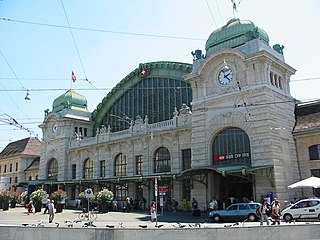
Basel SBB railway station is the central railway station in the city of Basel, Switzerland. Opened in 1854, and completely rebuilt in 1900–1907, it is Europe's busiest international border station. Basel SBB is owned by the Swiss Federal Railways (SBB CFF FFS). The other major railway station is Basel Badischer Bahnhof, operated by the German railway company Deutsche Bahn, on the north side of the Rhine from the city centre.

Basel Minster is a religious building in the Swiss city of Basel, originally a Catholic cathedral and today a Reformed Protestant church.

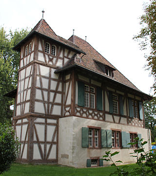
The Villa Merian, with its English Garden, stands on the elevated plain above Brüglingen in Münchenstein, in the canton of Basel-Country in Switzerland.

The Zoo Basel is constantly upgrading its infrastructure, but can hardly grow in area, as it is surrounded by the city of Basel, Switzerland, and, in the south, by Binningen. While most projects are upgrading older infrastructure and constructing multiple-animal exhibits, the zoo has plans to expand in area as well.

The Basel tramway network is a network of tramways forming part of the public transport system in Basel, Switzerland, and its agglomeration - it also reaches into adjacent suburbs in Germany and France. The only two other tramway networks to cross an international border are Geneva's and Strasbourg's tramways. The Basel tram system consists of 12 lines. Due to its longevity, it is part of Basel's heritage and, alongside the Basel Minster, is one of the symbols of the city.

Aesch Castle or Blarer Castle is a castle in the Swiss municipality of Aesch in the canton of Basel-Country.

Gundeldingen Castle is a castle in the Gundeldingen neighborhood of the municipality of Basel of the Canton of Basel-Stadt in Switzerland. It is a Swiss heritage site of national significance. Originally four related castles, today parts of only two remain.

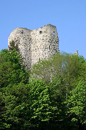
Pfeffingen Castle is a castle in the municipality of Pfeffingen of the canton of Basel-Land in Switzerland. It is a Swiss heritage site of national significance.

Karlstor in Munich is a medieval city gate, which served as a defensive fortification and a checkpoint.
The following is a timeline of the history of the city of Basel.

The fortifications of Frankfurt were a system of military defences of the German city of Frankfurt am Main which existed from the Middle Ages into the 19th century. Around 1000 the first city wall was built. It enclosed the area of what is now the Königspfalz in modern Frankfurt. In the twelfth century the settlement expanded into what is now Altstadt. For its protection an additional wall, the Staufenmauer, was erected. Starting in 1333, the Neustadt suburb developed north of the Altstadt and was encompassed by an additional wall with five gates. In the fifteenth century, a "landwehr border" was created around the entire territory of the Free City of Frankfurt. Beginning in 1628, the medieval city wall was developed to form a bastion fortress under the municipal architect Johann Dilich.


