Ben Nevis is the highest mountain in the British Isles. Standing at 1,345 metres (4,411 ft) above sea level, it is at the western end of the Grampian Mountains in the Lochaber area of the Scottish Highlands, close to the town of Fort William.

K2, also known as Mount Godwin-Austen or Chhogori, at 8,611 metres (28,251 ft) above sea level, is the second highest mountain in the world, after Mount Everest at 8,848 metres (29,029 ft). It is located on the China–Pakistan border between Baltistan in the Gilgit-Baltistan region of northern Pakistan, and the Taxkorgan Tajik Autonomous County of Xinjiang, China. K2 is the highest point of the Karakoram range and the highest point in both Pakistan and Xinjiang.

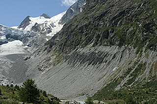
The Alpine region of Switzerland, conventionally referred to as the Swiss Alps, represents a major natural feature of the country and is, along with the Swiss Plateau and the Swiss portion of the Jura Mountains, one of its three main physiographic regions. The Swiss Alps extend over both the Western Alps and the Eastern Alps, encompassing an area sometimes called Central Alps. While the northern ranges from the Bernese Alps to the Appenzell Alps are entirely in Switzerland, the southern ranges from the Mont Blanc massif to the Bernina massif are shared with other countries such as France, Italy, Austria and Liechtenstein.

The Tödi, is a mountain massif and with the mountain peak Piz Russein the highest mountain in the Glarus Alps and the highest summit in the canton of Glarus, Switzerland. It is located on the border between the cantons of Graubünden, to the south, and Glarus, to the north, close to the point where those two cantons meet the canton of Uri, to the west. Although not the culminating point of Graubünden, it is its highest peak outside the Bernina range.

Mount Korab is the highest peak of the eponymous mountain range and the fourth highest mountain in the entire Balkan Peninsula, standing at 2,764 metres (9,068 ft).

Andøya is the northernmost island in the Vesterålen archipelago, situated about 300 kilometres (190 mi) inside the Arctic circle. Andøya is located in Andøy Municipality in Nordland county, Norway. The main population centres on the island include the villages of Andenes, Bleik, and Risøyhamn.

Monte Rosa is a mountain massif located in the eastern part of the Pennine Alps. It is located between Italy and Switzerland (Valais). Monte Rosa is the second highest mountain in the Alps and western Europe, after Mont Blanc.

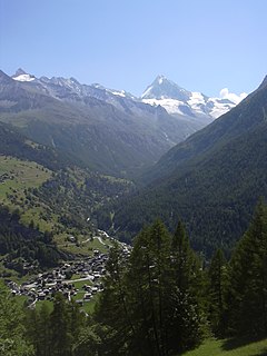
The Dom is a mountain of the Pennine Alps, located between Randa and Saas-Fee in the canton of Valais. With its 4,545 m (14,911 ft) summit it is the third highest mountain in the Alps and the second highest in Switzerland, after Monte Rosa. The Dom is the main summit of the Mischabel group, which is the highest massif lying entirely in Switzerland.
Summit Lake Provincial Park is a provincial park in British Columbia, Canada.
Summit Lake Provincial Park is located on Highway 6, 13 km southwest of Nakusp at the height of land between Slocan Lake and Upper Arrow Lake. The Nakusp Range of the Selkirk Mountains rises 500 metres above the lake, providing a magnificent backdrop to the many recreational opportunities provided by the park.
Park visitors can enjoy fishing for rainbow and cutthroat trout or swimming in the lake's clear, refreshing mountain water. Mountain Goats can often be viewed on rocky outcroppings and each fall a natural spectacle occurs as thousands of toads emerge from the lake and migrate to the nearby forest to hibernate for the winter.

The Saltoro Mountains are a subrange of the Karakoram Range. They are located in the heart of the Karakoram, on the southwest side of the Siachen Glacier, one of the two longest glaciers outside the polar regions. The name given to this range is shared with the Saltoro Valley which is located to the west of this range, downslope on the Pakistan side of the Actual Ground Position Line.

Mount Tomah is a locality and a mountain that is located in the Blue Mountains region of the state of New South Wales, Australia. The locality is known for the Blue Mountains Botanic Garden on the Bells Line of Road.

Mount Olympus is the highest mountain in Greece. It is located in the Olympus Range on the border between Thessaly and Macedonia, between the regional units of Pieria and Larissa, about 80 km (50 mi) southwest from Thessaloniki. Mount Olympus has 52 peaks, deep gorges, and exceptional biodiversity. The highest peak, Mytikas, meaning "nose", rises to 2,919 metres (9,577 ft). It is one of the highest peaks in Europe in terms of topographic prominence.

Mount Trickett, a mountain on the Great Dividing Range, is located approximately 6 kilometres (3.7 mi) west of Jenolan Caves, in the Central Tablelands region of New South Wales, Australia.

Thomas Cole Mountain is a mountain located in Greene County, New York. The mountain named for Thomas Cole (1801–1848), an artist who lived in the area, and is regarded as the founder of the Hudson River School.

The Aiguille du Tour is a mountain in the Mont Blanc massif, located on the border between Switzerland and France. The voie normale on the mountain is graded F (facile) and can be climbed from either the Albert Premier Hut on the French side or the Trient Hut on the Swiss side.

Mount Kelly is a mountain with an elevation of 1,829 metres (6,001 ft) AHD that is the tallest peak in the Scabby Range and is situated on the border of the Australian Capital Territory and New South Wales, Australia. The summit of the mountain is located within the ACT. The nearest town to the mountain is Adaminaby, approximately 32.8 kilometres (20.4 mi) to the south.

Zimmerberg is a mountain and a region located in the district of Horgen in the canton of Zurich, Switzerland. Its name bases on the Old High German word zimbar in the meaning of lumber.

Asperity Mountain is a mountain located in British Columbia, Canada, rising to 3,716 metres (12,192 ft). It is located between Tellot and Tiedemann Glaciers on the north and south respectively, in the Waddington Range, a subrange of the Pacific Ranges. The gorge of the Homathko River runs north to south on the east side of the mountain, carrying runoff from the mountain and glaciers to the Pacific Ocean.

Adlisberg, with an elevation of 701 metres (2,300 ft), is a wooded mountain in Switzerland overlooking Zürichsee to the northwest near the Zürichberg.

The White Goat Wilderness Area is a provincially designated wilderness area in the Canadian Rockies of Alberta. It was established in 1961 and it, as one of the three wilderness areas of Alberta, has the strictest form of government protection available in Canada. All development is forbidden and only travel by foot is permitted. Hunting and fishing are not allowed. The other two wilderness areas are Ghost River Wilderness Area and Siffleur Wilderness Area and together the three areas total 249,548.80 acres (100,988.82 ha).