
The Ashover Light Railway was a 1 ft 11+1⁄2 in narrow gauge railway in Derbyshire, England that connected Clay Cross and Ashover. It was built by the Clay Cross Company to transport minerals such as limestone, fluorite, barytes and gritstone to its works at Clay Cross and for transport around the country by the LMS.

The Leadhills and Wanlockhead Railway is a 2 ft narrow gauge railway in South Lanarkshire, Scotland. It is laid on the trackbed of the former Leadhills and Wanlockhead Branch of the Caledonian Railway which led off the main line between Carlisle and Glasgow at Elvanfoot.

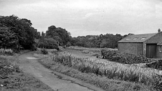
Auchenmade railway station was a railway station approximately three miles (4.8 km) north-east of Kilwinning on the B707, North Ayrshire, Scotland. It served the hamlet of Auchentiber and the surrounding rural area as part of the Lanarkshire and Ayrshire Railway. The station was 6.75 miles (10.86 km) from the Lugton East Junction.
The Leadhills and Wanlockhead Light Railway was a short branch railway built in Scotland to serve mining settlements, high in the Lowther Hills, connecting them to the Carlisle - Carstairs main line. The line was opened in 1901 - 1902, and was the highest standard gauge railway line in the British Isles. Hoped-for developments did not emerge, and when the world lead price slumped in the 1920s, the line sustained heavy losses. It was closed on 2 January 1939.

Elvanfoot railway station was a station which served Elvanfoot, in the Scottish county of South Lanarkshire. It was served by local trains on what is now known as the West Coast Main Line.
Balerno railway station was opened in 1874 and served the area of the village of Balerno that now forms part of the city of Edinburgh. Although primarily built as a goods line, with a dedicated goods station at Balerno, serving the many mills on the Water of Leith, a passenger service was provided by the Caledonian Railway using the Balerno Loop and after grouping by the London, Midland and Scottish Railway, seeing formal closure to passenger traffic shortly after nationalisation. The station was the only one with a separately served goods station on the 'loop' line and lay in rural surroundings that had been popular with families having a day out in the country.

Waenavon railway station, also known as Waen Avon, was a station on the Brynmawr and Blaenavon Railway in South East Wales. To the south of the station a short line served Milfraen Colliery.
Loudounhill was a railway station on the Darvel and Strathaven Railway serving a rural area that included the landmark of Loudoun Hill in the Parish of Galston, East Ayrshire, Scotland.

Ryeland was a railway station on the Darvel and Strathaven Railway serving Caldermill and the surrounding rural area in South Lanarkshire, Scotland.

Strathaven Central or Strathaven was a railway station on the Darvel and Strathaven Railway serving the town of Strathaven in South Lanarkshire, Scotland. The station opened as an extension of the line from Stonehouse and in 1904 was connected with the Hamilton and Strathaven Railway via a link to Strathaven North. It was renamed as 'Strathaven' a few months before closure.
Machrihanish was a railway station in the village of Machrihanish, Argyll and Bute, serving the town. The Campbeltown and Machrihanish Light Railway was a 2 ft 3 in (686 mm) narrow gauge railway in Kintyre, Scotland, between the towns of Campbeltown and Machrihanish.

Lissens Goods station or Lissens Sidings station was a railway freight facility located approximately two miles north-east of Kilwinning, North Ayrshire, Scotland. It served the industrial and agricultural requirements for transportation in the vicinity of Auchenmade and the surrounding rural area on behalf of the Lanarkshire and Ayrshire Railway. Lissens Goods was around seven miles from the Lugton East Junction and the railway workers employed here were supervised by staff from the nearby Auchenmade Station, the nearest passenger and goods station on the up line towards Lugton and Glasgow.

Killochan railway station was located in a rural part of South Ayrshire, Scotland and mainly served the nearby Killochan Castle estate. The Killochan bank is the name given to this section of the line, running from Girvan on an uphill gradient to just north of the old station site. Maybole is around nine miles away and Girvan two miles.

The Grangeston Halt railway station was a private station that was not listed in the public timetables, located in a rural part of South Ayrshire, Scotland and served the WWII Grangeston ICI munitions plant bringing workers to the site. Grant's Distillery now occupies much of the site.

Girvan Old railway station was a terminus station opened in Girvan, in Carrick, South Ayrshire, Scotland by the Maybole and Girvan Railway. Although ambitions existed to extend the line through to Stranraer it was built on a site that would not permit this and so when the line was built the Girvan New station was opened on 5 October 1877 by the Girvan and Portpatrick Junction Railway on the route to Pinmore and eventually through to Stranraer railway station.
Mennock Lye Goods Depot or Mennock Siding was a railway freight facility located off the A76 in the hamlet of Mennock that lies circa two miles south-east of Sanquhar, Dumfries and Galloway, Scotland. Situated 68 miles (109 km) from Glasgow it served the industrial and agricultural requirements for transportation in the vicinity of Mennock and the surrounding rural area, originally on behalf of the Glasgow, Dumfries and Carlisle Railway. The goods depot was located on a section of line with a falling southbound gradient of 1 in 160. No passenger railway station has been recorded for Mennock.

Colinton railway station was opened in 1874 and served the area of the then village of Colinton that now forms part of the city of Edinburgh, with Colinton House nearby. Although primarily built as a goods line to serve the many mills on the Water of Leith, a passenger service was provided by the Caledonian Railway using the Balerno Loop and after grouping by the London, Midland and Scottish Railway, seeing formal closure to passenger traffic shortly after nationalisation.

Juniper Green railway station was opened in 1874 and served the area of the then village of Juniper Green that now forms part of the city of Edinburgh. Although primarily built as a goods line to serve the many mills on the Water of Leith, a passenger service was provided by the Caledonian Railway using the Balerno Loop and after grouping by the London, Midland and Scottish Railway, seeing formal closure to passenger traffic shortly after nationalisation. The station lay in rural surroundings despite being only a short distance from the centre of Edinburgh and had been popular with families having a day out in the country.

Currie railway station was opened in 1874 and served the area of the village of Currie that now forms part of the city of Edinburgh. Although primarily built as a goods line to serve the many mills on the Water of Leith, a passenger service was provided by the Caledonian Railway using the Balerno Loop and after grouping by the London, Midland and Scottish Railway, seeing formal closure to passenger traffic shortly after nationalisation. The station was the largest on the 'loop' line and lay in rural surroundings and had once been popular with families having a day out in the country.
Leadhills railway station was opened on 1 October 1901 as the intermediate stop on the Leadhills and Wanlockhead Light Railway and served the lead mining area, farms and the village of Leadhills circa 5.5 miles (8.9 km) WSW of Elvanfoot railway station in South Lanarkshire until 2 January 1939 for passengers and freight. Until Wanlockhead station opened Leadhills was the highest standard gauge adhesion station in the United Kingdom.
