Ocoruro or Uqururu is one of eight districts of the Espinar Province in Peru.
Taqrachullu, Pukara Taqrachullu, T'akrachullu, Pukara T'akrachullu or María Fortaleza is an archaeological site in Peru. It is located in the Cusco Region, Espinar Province, Suykutambo District.

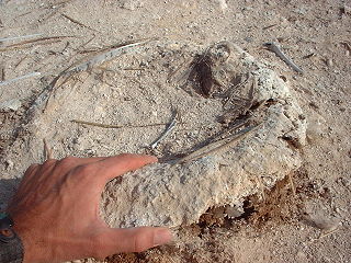
Wilca is an archaeological site in Peru. It is situated in the Amazonas Region, Utcubamba Province, in the east of the Cajaruro District, near the border with the Bongara Province.
Kiswarani Q'asa is a mountain in the Andes of Peru. Its summit reaches about 4,862.8 m (15,954 ft) above sea level. The mountain is located in the Cusco Region, Espinar Province, Coporaque District.
Laramani is a mountain in the Andes of Peru, about 4,922.8 metres (16,151 ft) high. It is located in the Cusco Region, Canas Province, on the border of the districts Kunturkanki and Layo, and in the Espinar Province, Pichigua District. A stream named Pumanuta originates east of the mountain. It flows to the lake Langui Layo north of Laramani.

Choquepirhua is a mountain in the Chila mountain range in the Andes of Peru, about 5,400 metres (17,717 ft) high. It lies in the Arequipa Region, Castilla Province, on the border of the districts of Chachas and Choco. Choquepirhua is situated south of Chila.
Chuquiananta is a mountain in the Andes of southern Peru, about 5,300 metres (17,388 ft) high. It is situated in the Moquegua Region, Mariscal Nieto Province, Torata District, and in the Tacna Region, Candarave Province, Camilaca District. Chuquiananta lies south-west of Tutupaca volcano, south-east of Pomani.
Chuqi Pirwa is a mountain in the Andes of Peru, about 5,200 m (17,100 ft) high. It is situated in the Cusco Region, Espinar Province, Condoroma District, and in the Puno Region, Lampa Province, Ocuviri District. Chuqi Pirwa lies southwest of Sawanani Lake (Saguanani) and northwest of Qullqi Q'awa.

Cuncapata is a mountain in the Vilcanota mountain range in the Andes of Peru, about 5,400 metres (17,717 ft) high. It is located in the Cusco Region, Canchis Province, Pitumarca District. Cuncapata lies southwest of the mountain Jatunñaño Punta, north of the lake Sibinacocha and southeast of Chumpe.
Waña is a mountain in the Wansu mountain range in the Andes of Peru, about 5,400 metres (17,717 ft) high. It is situated in the Cusco Region, Chumbivilcas Province, Santo Tomás District. Waña lies northwest of Wamanripa, northeast of Chankuwaña, east of Wayunka and southeast of Ikma.
Pisquioc is a mountain in the Vilcanota mountain range in the Andes of Peru, about 5,000 m (16,000 ft) high. It is located in the Cusco Region, Quispicanchi Province, Marcapata District, south of Aquichua.
Mullu Q'awa is an archaeological site in Peru on a mountain of that name. It is located in the Cusco Region, Espinar Province, Alto Pichigua District. It lies near the village of Mullu Q'awa (Molloccahua, Molloqhawa). It is situated on top of the mountain at a height of about 4,000 m (13,000 ft).
Sondor (possibly from Aymara sunturu square without a ridge, Quechua suntur circular, is a mountain in the Andes of Peru, about 4,800 metres high. It is located in the Apurímac Region, Abancay Province, Circa District, and in the Antabamba Province, El Oro District. It lies southeast of a mountain named Sunturu.
Jañuma Pirwa is a 5,125-metre-high (16,814 ft) mountain in the Andes of Peru. It is located in the Arequipa Region, Caylloma Province, Tisco District. It lies southwest of Chuqi Pirwa and southeast of Pirwa.
Chuqi Pirwa is a mountain in the Andes of Peru, about 4,800 m (15,700 ft) high. It is located in the Arequipa Region, Caylloma Province, Tisco District, and in the Espinar Province, Yauri District. It lies northeast of Jañuma Pirwa and east of Pirwa.
Atawallpa is a mountain in the Andes of Peru, about 5,000 m (16,000 ft) high. It is located in the Cusco Region, Espinar Province, on the border of the districts of Condoroma and Ocoruro. The mountain northwest of it is Atawallpa Much'u. Atawallpa lies at a lake named Wallatani.
Aguillane or Aquillane is a mountain in the Andes of Peru, about 5,000 m (16,000 ft) high. It is located in the Cusco Region, Espinar Province, Condoroma District. Aguillane lies southwest of Atawallpa.
Atawallpa Much'u is a mountain in the Andes of Peru, about 5,000 m (16,000 ft) high. It is located in the Cusco Region, Espinar Province, on the border of the districts of Condoroma and Ocoruro. Atawallpa Much'u lies northwest of Atawallpa.
Aqhu Phichaqa is a mountain in the Andes of Peru, about 4,800 m (15,700 ft) high. It is located in the Cusco Region, Espinar Province, on the border of the districts of Condoroma and Ocoruro. Aqhu Phichaqa lies between Yana Urqu in the northeast and Janq'u Q'awa in the southwest.
Isankani is a 4,925-metre-high (16,158 ft) mountain in the Andes of Peru. It is located in the Cusco Region, Espinar Province, on the border of the districts of Condoroma and Ocoruro. Isankani lies east of Aqhu Phichaqa.