Omasuyos or Uma Suyu is a province in the La Paz Department in Bolivia. Its capital is Achacachi.

Ancohuma or Janq'u Uma is the third highest mountain in Bolivia. It is located in the northern section of the Cordillera Real, part of the Andes, east of Lake Titicaca. It lies just south of the slightly lower Illampu, near the town of Sorata.

Chearoco, Chiaraco or Chiaroco is a mountain in the Cordillera Real in the Andes of Bolivia. It has a height of about 6,127 m (20,102 ft). It is situated in the La Paz Department, Larecaja Province, Guanay Municipality, southeast of the peak of Aman Pata. Chearoco lies between Qalsata in the northwest and Chachakumani in the southeast.

Cairoma is a location in the La Paz Department in Bolivia. It is the seat of the Cairoma Municipality, the fifth municipal section of the José Ramón Loayza Province.
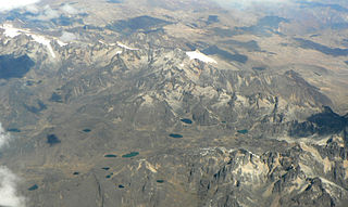
The Cordillera Quimsa Cruz is a mountain range in the La Paz Department in Bolivia situated south east of Lake Titicaca and north of Lake Uru Uru, measuring about 35-40 km in length and 12 km at its widest point. It is the continuation of the Cordillera Real of Bolivia extending in a north to south-eastern direction from Asiento pass south of Illimani to Tres Cruces pass.
Wiluyu Janq'u Uma or Wiluyu is a mountain in the Cordillera Real in the Andes of Bolivia, about 5,540 metres (18,176 ft) high. It is located in the La Paz Department, Larecaja Province, Sorata Municipality. It lies northwest of the mountain Yapuchañani, northeast of Misk'i T'ant'a and Uma Jalanta and east of Illampu.
Taruja Umaña, also known as Taruj Umaña according to the name of the river at the mountain, is a 4,852-metre-high (15,919 ft) mountain in the northern part of the Kimsa Cruz mountain range in the Bolivian Andes. It is situated in the La Paz Department, Loayza Province, Cairoma Municipality. Taruja Umaña lies west of the mountain Mama Uqllu.
Achuma is a mountain in the northern part of the Kimsa Cruz mountain range in the Bolivian Andes, about 4,960 metres (16,273 ft) high. It is situated in the La Paz Department, Loayza Province, Cairoma Municipality. The peaks of Achuma lie north-west to north of the mountain Taruja Umaña and south of Janq'u Willk'i. There are two small lakes north of the mountain. They are named Allqa Quta and Ch'iyar Quta.
Janq'u Willk'i is a mountain in the northern part of the Kimsa Cruz mountain range in the Bolivian Andes, about 4,800 metres (15,748 ft) high. It is situated in the La Paz Department, Loayza Province, Cairoma Municipality. Janq'u Willk'i lies north of the mountains Taruja Umaña and Achuma. There are two small lakes at the feet of Achuma and Janq'u Willk'i. They are named Allqa Quta and Ch'iyar Quta.
Warus Quta is a lake in the Kimsa Cruz mountain range in the Andes of Bolivia. It is situated in the La Paz Department, Loayza Province, Cairoma Municipality. Warus Quta lies between the mountains Taruja Umaña in the west and Mama Uqllu in the east. The river Taruj Umaña originates near the lake. It flows to the west and then to the north-west as an affluent of the La Paz River.
Chillwa Quta is a lake in the Kimsa Cruz mountain range in the Andes of Bolivia. It is situated in the La Paz Department, Loayza Province, Cairoma Municipality. Chillwa Quta lies south-west of the mountain Mama Uqllu, south of the lake Warus Quta and south-east of the mountain Taruja Umaña. This is where the river Taruj Umaña originates. It flows to the west and then to the north-west as an affluent of the La Paz River.
Kuntur Jiwaña is a mountain in the Bolivian Andes which reaches a height of approximately 3,760 m (12,340 ft). It is located in the La Paz Department, Loayza Province, on the border of the municipalities of Cairoma and Luribay. Kuntur Jiwaña lies east of Janq'u Willk'i.
Jukumarini is a 3,662-metre-high (12,014 ft) mountain in the Bolivian Andes. It is located in the La Paz Department, Loayza Province, Luribay Municipality.
Janq'u Jaqhi is a mountain in the Bolivian Andes which reaches a height of approximately 3,400 m (11,200 ft). It is located in the La Paz Department, Loayza Province, Luribay Municipality. It lies northeast of Jukumarini and southeast of Sawaya.
Liqiliqini is a 3,928-metre-high (12,887 ft) mountain in the Bolivian Andes. It is located in the La Paz Department, Loayza Province, Cairoma Municipality, southwest of the village of Wila Pampa. Liqiliqini lies northwest of Wayra Willk'i, Wanuni and Uyuyuni.
Wila Willk'i is a mountain in the Bolivian Andes which reaches a height of approximately 480 m (1,570 ft). It is located in the La Paz Department, Loayza Province, Cairoma Municipality. This is where the Wila Willk'i Jawira originates. It flows to the northwest as an affluent of the Luribay River.
Wayra Willk'i is a mountain in the Bolivian Andes which reaches a height of approximately 4,100 m (13,500 ft). It is located in the La Paz Department, Loayza Province, Cairoma Municipality, northwest of Cairoma. Wayra Willk'i lies north of Pukara Ch'utu and southeast of Wanuni.
Janq'u Quta is a mountain in the Bolivian Andes which reaches a height of approximately 4,940 m (16,210 ft). It is located in the La Paz Department, Loayza Province, Cairoma Municipality.
Jach'a Willk'i is a mountain in the Bolivian Andes which reaches a height of approximately 4,000 m (13,000 ft). It is located in the La Paz Department, Loayza Province, Cairoma Municipality.
Turini is a mountain in the Bolivian Andes which reaches a height of approximately 5,120 m (16,800 ft). It is located in the La Paz Department, Loayza Province, Cairoma Municipality, and in the Inquisivi Province, Quime Municipality. Turini lies northeast of Taruja Umaña and the lake named Warus Quta