
Puno is a department in southeastern Peru. It is bordered by Bolivia on the east, the departments of Madre de Dios on the north, Cusco and Arequipa on the west, Moquegua on the southwest, and Tacna on the south. Its capital is the city of Puno, which is located on Lake Titicaca in the geographical region known as the Altiplano or high sierra.

Puno is a province in the Puno Region, in southeastern Peru. It borders the provinces of Huancane, San Román, El Collao and the Moquegua Region's province of General Sánchez Cerro. Its capital is the city of Puno, which is located at the edge of Lake Titicaca, the world's highest navigable lake. It is the economic powerhouse of the region.

Sandia Province is a province of the Puno Region in Peru. The capital of the province is the city of Sandia.
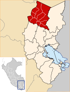
Carabaya Province is a province of the Puno Region in the southern part of Peru. It is bounded on the north by the Madre de Dios Region, on the east by the Sandia Province, on the south by the provinces of Azángaro, Melgar and Putina and on the west by the Cusco Region. The capital of the province is the city of Macusani.
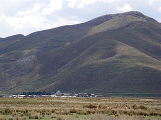
Crucero District is one of ten districts of the province Carabaya in Peru.
Pichacani or Pichaqani is one of fifteen districts of the Puno Province in the Puno Region in Peru.

Chaupi Orco or Viscachani is a mountain in the Andes on the border of Bolivia and Peru. It has a height of 6,044 metres (19,829 ft). On the Bolivian side it is located in the La Paz Department, Franz Tamayo Province, Pelechuco Municipality, and on the Peruvian side it lies in the Puno Region, Putina Province, Sina District. It lies north of Salluyu.

Jach'a Waracha is a mountain in the Apolobamba mountain range in Bolivia, about 5,540 metres (18,176 ft) high. It is situated in the La Paz Department, Franz Tamayo Province, Pelechuco Municipality. Jach'a Waracha lies west of the mountain Waracha and north-west of the mountain Qala Phusa.
Mallkuamaya is an archaeological site in Peru. It is located in the Puno Region, Puno Province, Puno District, about 15 km southwest of Puno. The site was declared a National Cultural Heritage (Patrimonio Cultural) of Peru by the National Institute of Culture.

Qulu Qulu is an archaeological site in Peru. It is located in the Puno Region, Sandia Province, Patambuco District. The site was declared a National Cultural Heritage (Patrimonio Cultural) of Peru by the National Institute of Culture.
Molloko is an archaeological site in Peru. It is located in the Puno Region, Puno Province, Acora District, about 5 km south of the town of Acora, near the village of Molloco. The site was declared a National Cultural Heritage (Patrimonio Cultural) by the National Institute of Culture.
Tanqa Tanqa or Tanka Tanka is an archaeological site in Peru. It is located in the Puno Region, Chucuito Province, Zepita District. The site was declared a National Cultural Heritage (Patrimonio Cultural) of Peru.
Pukarani is a mountain with an archaeological site of the same name in the Andes of Peru, about 4,301.9 m (14,114 ft) high. It is located in the Puno Region, Lampa Province, Nicasio District.
Kuntur Ikiña is a mountain in the Andes of Peru, about 4,800.9 metres (15,751 ft) high. It is located in the Puno Region, Puno Province, on the border of the districts Mañazo and Tiquillaca.
Aricoma is a mountain in the Andes of Peru, about 5,350 metres (17,552 ft) high. It is located in the Puno Region, Carabaya Province, Crucero District, and in the Sandia Province, Limbani District. The mountain lies east of Aricoma Lake and northwest of Jalahuana.
Kuntur Puñuna is a mountain in the Andes of Peru, about 4,800 metres (15,748 ft) high. It is located in the Puno Region, Lampa Province, Santa Lucía District.
Tankani is a mountain in the Andes of southern Peru, about 5,000 metres (16,404 ft) high. It is situated in the Puno Region, Puno Province, San Antonio District, near the border with the Moquegua Region. Tankani lies northwest of the mountain Chuqipata.
Puka Pukayuq is a mountain in the Andes of Peru, about 4,800 metres (15,748 ft) high. It is located in the Puno Region, Sandia Province, Limbani District It lies northeast of the peaks of Ariquma, Ankayuq K'uchu and Wirta Pata, and north of a lake named Ch'uxñaquta.
Yana Urqu is a mountain in the Andes of Peru, about 5,000-metre (16,000 ft) high. It is located in the Puno Region, Sandia Province, Limbani District. It lies near Ariquma.
Chuqi Quta is a mountain in the Andes of Peru, about 5,200 metres (17,060 ft) high. It is located in the Puno Region, El Collao Province, Santa Rosa District. It lies southwest of Jisk'a Mawruma.


