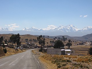
Omasuyos or Uma Suyu is a province in the La Paz Department in Bolivia. Its capital is Achacachi.

Ancohuma or Janq'u Uma is the third highest mountain in Bolivia. It is located in the northern section of the Cordillera Real, part of the Andes, east of Lake Titicaca. It lies just south of the slightly lower Illampu, near the town of Sorata.

Q'asiri is a mountain in the Cordillera Real in the Andes of Bolivia, about 5,828 m (19,121 ft) high. It is located in the La Paz Department, Larecaja Province, Sorata Municipality. It is situated south-east of the mountain Janq'u Uma, north-west of the mountains Qalsata and Ch'iyar Juqhu and north-east of San Francisco Lake.

Uma Jalanta is a mountain in the Cordillera Real in the Andes of Bolivia, about 5,723 metres (18,776 ft) high. It is located in the La Paz Department, Larecaja Province, Sorata Municipality. It lies south-east of the mountains Janq'u Uma and Janq'u Piti, near the mountain Misk'i T'ant'a.

Wiluyu Janq'u Uma or Wiluyu is a mountain in the Cordillera Real in the Andes of Bolivia, about 5,540 metres (18,176 ft) high. It is located in the La Paz Department, Larecaja Province, Sorata Municipality. It lies northwest of the mountain Yapuchañani, northeast of Misk'i T'ant'a and Uma Jalanta and east of Illampu.

Llawi Imaña is a 4,854-metre-high (15,925 ft) mountain in the Andes of Bolivia. It is situated in the La Paz Department, Larecaja Province, Sorata Municipality, north of the Cordillera Real.
Ch'uch'u Jawira is a Bolivian river in the La Paz Department, Larecaja Province, Sorata Municipality. Its waters flow the Kaka River which belongs to the watershed of the Beni River.

Ch'uch'u is a mountain in the Andes of Bolivia, about 5,100 metres (16,732 ft) high. It is situated in the La Paz Department, Larecaja Province, Sorata Municipality. Ch'uch'u lies north of the main range of the Cordillera Real, north to northeast of the mountain Ch'uch'u Apachita. This is where the river Ch'uch'u Jawira originates.

P'iq'iñ Qullu is a mountain in the north of the Cordillera Real in the Andes of Bolivia, about 4,875-metre (15,994 ft) high. It is situated in the La Paz Department, Larecaja Province, Sorata Municipality. P'iq'iñ Qullu lies west of the Janq'u Uma-Illampu massif southeast of Sorata.

Chunta Qullu is a mountain in the Andes of Bolivia, about 4,800-metre (15,748 ft) high. It is situated in the La Paz Department, Larecaja Province, Sorata Municipality, north of the Cordillera Real. Chunta Chullu lies southeast of the mountain Ch'uch'u and northwest of the mountain Llawi Imaña.

Wankar Quta Qullu is a mountain in the Andes of Bolivia, about 4,900 metres (16,076 ft) high. It is situated in the La Paz Department, Larecaja Province, Sorata Municipality, north of the main range of the Cordillera Real. Wankar Quta Qullu lies northeast of the mountain Wila Wilani. South of it there is a lake named Q'asiri Quta. A little river named Q'asiri Jawira originates here. It flows to Ch'uch'u Jawira in the south.

Ch'uch'u Apachita is a 4,855-metre-high (15,928 ft) mountain in the Andes of Bolivia. It is situated in the La Paz Department, Larecaja Province, Sorata Municipality. Ch'uch'u Apachita lies north of the main range of the Cordillera Real, south to southwest of the mountain Ch'uch'u, northwest of Chunta Qullu and east of Jukumarini. This is where the river Ch'uch'u Jawira originates.

Jukumarini is a 4,552-metre-high (14,934 ft) mountain in the Andes of Bolivia. It is situated in the La Paz Department, Larecaja Province, Sorata Municipality. Jukumarini lies north of the main range of the Cordillera Real, southwest of the mountain Ch'uch'u and west of Ch'uch'u Apachita.

Quriwani is a mountain in the northern extensions of the Cordillera Real in the Andes of Bolivia which reaches a height of approximately 4,920 m (16,140 ft). It is located in the La Paz Department, Larecaja Province, Sorata Municipality. It lies north of Ch'uch'u. The small lake southwest of Quriwani is named Quriwani Machu.

Allqamarini is a mountain in the northern extensions of the Cordillera Real in the Andes of Bolivia which reaches a height of approximately 4,600 m (15,100 ft). It is located in the La Paz Department, Larecaja Province, Sorata Municipality. It lies southwest of Quriwani. The small lake southeast of Allqamarini is Quriwani Machu.

Phallata is a mountain north of the Cordillera Real in the Andes of Bolivia which reaches a height of approximately 4,780 m (15,680 ft). It is located in the La Paz Department, Larecaja Province, Sorata Municipality. It lies at a lake of that name (Pallada).

Achachi Qala is a mountain north of the Cordillera Real in the Andes of Bolivia which reaches a height of approximately 4,760 m (15,620 ft). It is located in the La Paz Department, Larecaja Province, Quiabaya Municipality. Achachi Qala lies southwest of Saywani, northeast of Quriwani and east of Mitalani.

Saywani is a mountain north of the Cordillera Real in the Andes of Bolivia which reaches a height of approximately 4,760 m (15,620 ft). It is located in the La Paz Department, Larecaja Province, Quiabaya Municipality. Saywani lies northeast of Achachi Qala. The little lake south of Saywani is named Ch'uxña Quta.

Saywani is a mountain north of the Cordillera Real in the Andes of Bolivia which reaches a height of approximately 4,480 m (14,700 ft). It is located in the La Paz Department, Larecaja Province, Sorata Municipality. Saywani lies north of Jichu Quta. The Wayllani Jawira originates near the mountain. It flows to the west.

Jichu Quta is a mountain north of the Cordillera Real in the Andes of Bolivia which reaches a height of approximately 4,560 m (14,960 ft). It is located in the La Paz Department, Larecaja Province, Sorata Municipality, at the border with the Quiabaya Municipality. Jichu Quta lies south of Saywani at a lake named Quriwari. The Wayllani Jawira originates near the mountain. It flows to the west.


