Wards of Kyoto

Last updated
Wards of Kyoto Kyoto city map.png
Wards of Kyoto

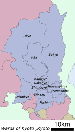
The city of Kyoto in Kyoto Prefecture, Japan has eleven wards.

Wards of Kyoto
NameJapaneseEstablishedCode [1]
Fushimi-ku 伏見区1931 (by merger of surrounding municipalities)261092
Higashiyama-ku 東山区1921 (divided from Kamigyō)261050
Kamigyō-ku 上京区1879 (one of original two wards)261025
Kita-ku 北区1955 (divided from Kamigyō)261017
Minami-ku 南区1955 (divided from Shimogyō)261076
Nakagyō-ku 中京区1929 (divided from Kamigyō and Shimogyō)261041
Nishikyō-ku 西京区1976 (divided from Ukyō)261114
Sakyō-ku 左京区1929 (divided from Kamigyō)261033
Shimogyō-ku 下京区1879 (one of original two wards)261068
Ukyō-ku 右京区1931 (by merger of surrounding municipalities)261084
Yamashina-ku 山科区1976 (divided from Higashiyama)261106

Unlike the 23 special wards of Tokyo, the wards of Kyoto are not separate municipalities, they are divisions just for municipal administration. Together, they comprise the city of Kyoto, under a single mayor and city council.

Area, Population and Density (2015)
NamePopulationDensity (/km²)Area (km²)% of totalForest Area (km²)Forest CoverInhabitable Area
(km²)Density (/km²)
Fushimi-ku 280,6554,55261.667.4%14.5823.6%47.125,956
Higashiyama-ku 39,0445,2207.480.9%1.5821.1%5.906,618
Kamigyō-ku 85,11312,1077.030.8%0.000.0%7.0312,107
Kita-ku 119,4741,25994.8811.5%78.8583.1%16.027,458
Minami-ku 99,9276,32015.811.9%0.000.0%15.816,320
Nakagyō-ku 109,34114,7567.410.9%0.000.0%7.4114,756
Nishikyō-ku 150,9622,54859.247.2%32.5354.9%26.825,629
Sakyō-ku 168,266682246.7729.8%215.2687.2%31.555,333
Shimogyō-ku 82,66812,1936.780.8%0.000.0%6.7812,193
Ukyō-ku 204,262699292.0735.3%253.7786.9%38.295,335
Yamashina-ku 135,4714,72028.703.5%13.6447.5%15.408,797
Total 1,475,1831,782827.83100.0%610.2173.7%218.136,763

Related Research Articles

Kyoto City in Kansai, Japan

Kyoto, officially Kyoto City, is the capital city of Kyoto Prefecture in Japan. Located in the Kansai region on the island of Honshu, Kyoto forms a part of the Keihanshin metropolitan area along with Osaka and Kobe. As of 2018, the city had a population of 1.47 million.

Prefectures of Japan countrys 47 first-order subnational jurisdictions

Japan is divided into 47 prefectures, forming the country's first level of jurisdiction and administrative division. They include 43 prefectures proper, two urban prefectures, one "circuit" or "territory" and one "metropolis". In 1868, the Meiji Fuhanken sanchisei administration created the first prefectures to replace the urban and rural administrators in the parts of the country previously controlled directly by the shogunate and a few territories of rebels/shogunate loyalists who had not submitted to the new government such as Aizu/Wakamatsu. In 1871, all remaining feudal domains (han) were also transformed into prefectures, so that prefectures subdivided the whole country. In several waves of territorial consolidation, today's 47 prefectures were formed by the turn of the century. In many instances, these are contiguous with the ancient ritsuryō provinces of Japan.

Cities designated by government ordinance of Japan Type of Japanese city

A city designated by government ordinance, also known as a designated city or government ordinance city, is a Japanese city that has a population greater than 500,000 and has been designated as such by order of the Cabinet of Japan under Article 252, Section 19 of the Local Autonomy Law.

The Japanese addressing system is used to identify a specific location in Japan. When written in Japanese characters, addresses start with the largest geographical entity and proceed to the most specific one. When written in Latin characters, addresses follow the convention used by most Western addresses and start with the smallest geographic entity and proceed to the largest. The Japanese system is complex and idiosyncratic, the product of the natural growth of urban areas, as opposed to the systems used in cities that are laid out as grids and divided into quadrants or districts.

Tokyo City historic municipality in Japan, 1889-1943. now area of 23 special wards

Tokyo City was a municipality in Japan and part of Tokyo-fu which existed from 1 May 1889 until its merger with its prefecture on 1 July 1943. The historical boundaries of Tokyo City are now occupied by the 23 Special Wards of Tokyo. The new merged government became what is now Tokyo, also known as the Tokyo Metropolis, or, ambiguously, Tokyo Prefecture.

Ukyō-ku, Kyoto Ward of Kyoto in Kinki, Japan

Ukyō-ku (右京区) is one of the eleven wards in the city of Kyoto, in Kyoto Prefecture, Japan.

Nijō Castle castle in Kyoto, Japan

Nijō Castle is a flatland castle in Kyoto, Japan. The castle consists of two concentric rings (Kuruwa) of fortifications, the Ninomaru Palace, the ruins of the Honmaru Palace, various support buildings and several gardens. The surface area of the castle is 275,000 square metres, of which 8,000 square metres (86,000 sq ft) is occupied by buildings.

Fushimi-ku, Kyoto Ward of Kyoto in Kinki, Japan


Fushimi is one of the eleven wards in the city of Kyoto, in Kyoto Prefecture, Japan. Famous places in Fushimi include the Fushimi Inari Shrine, with thousands of torii lining the paths up and down a mountain; Fushimi Castle, originally built by Toyotomi Hideyoshi, with its rebuilt towers and gold-lined tea-room; and the Teradaya, an inn at which Sakamoto Ryōma was attacked and injured about a year before his assassination. Also of note is the Gokōgu shrine, which houses a stone used in the construction of Fushimi Castle. The water in the shrine is particularly famous and it is recorded as one of Japan's 100 best clear water spots.

Kamo River river in Kyoto Prefecture, Japan

The Kamo River is located in Kyoto Prefecture, Japan. The riverbanks are popular walking spots for residents and tourists. In summer, restaurants open balconies looking out to the river. There are pathways running alongside the river on which one can walk along the river, and some stepping stones that cross the river. The water level of the river is usually relatively low; less than one meter in most places. During the rainy season, however, the pathways sometimes flood in their lower stretches.

Sanjō Station (Kyoto) Railway station in Kyoto, Japan

Sanjō Station is the main Keihan Electric Railway station in Kyoto. It connects with Sanjo Keihan Station on the Kyoto Subway Tozai Line. It was opened for service on October 27, 1915, and has been in service ever since. Sanjo Station is located in the Higashiyama Ward, in Kyoto City. The station offers quick access to the Gion district and the main shopping district on Sanjo-dori.

Higashiyama-ku, Kyoto Ward of Kyoto

Higashiyama is one of the eleven wards in the city of Kyoto, in Kyoto Prefecture, Japan.

Kamigyō-ku Ward of Kyoto

Kamigyō-ku (上京区) is one of the eleven wards in the city of Kyoto, in Kyoto Prefecture, Japan. Located in the center of the present-day city of Kyoto, Japan it previously occupied the northern region of the ancient capital of Kyoto. The Kamo River flows on the eastern border of the ward. The area was previously a district of residences for the royalty and upper classes in the old capital.

Sakyō-ku, Kyoto Ward of Kyoto

Sakyō-ku is one of the eleven wards in the city of Kyoto, in Kyoto Prefecture, Japan.

Kita-ku, Kyoto Ward of Kyoto

Kita is one of the eleven wards in the city of Kyoto, in Kyoto Prefecture, Japan. Its name means "North Ward." As of 2016, the ward has an estimated population of 119,074 people.

Minami-ku, Kyoto Ward of Kyoto

Minami is one of the eleven wards in the city of Kyoto, in Kyoto Prefecture, Japan. Its name means "South Ward." It was established in 1955 when it was separated from Shimogyo-ku. As of April, 2016 the ward has an estimated population of 100,781 people. The Kamo River and the Katsura River flow through the district. It is home to several historical places and temples.

Nakagyō-ku, Kyoto Ward of Kyoto

Nakagyō-ku (中京区) is one of the eleven wards in the city of Kyoto, in Kyoto Prefecture, Japan. Its name means "central capital ward."

Shimogyō-ku, Kyoto Ward of Kyoto

Shimogyō-ku (下京区) is one of the eleven wards in the city of Kyoto, in Kyoto Prefecture, Japan. First established in 1879, it has been merged and split, and took on its present boundaries in 1955, with the establishment of a separate Minami-ku.

Yamashina-ku, Kyoto Ward of Kyoto

Yamashina is one of the eleven wards in the city of Kyoto, in Kyoto Prefecture, Japan. It lies in the southeastern part of the city, and Yamashina Station is one stop away from Kyoto Station on the Tōkaidō Main Line.

Nishikyō-ku, Kyoto Ward of Kyoto

Nishikyō-ku (西京区) is one of the eleven wards in the city of Kyoto, in Kyoto Prefecture, Japan. Its name means "west capital ward" and it is situated on the western edge of the city, to the south of center. The ward was established on October 1, 1976, after it was separated from Ukyō-ku. The Katsura River is the border between Nishikyo-ku and Ukyo-ku.

Fushimi-Momoyama Station Railway station in Kyoto, Japan

Fushimi-Momoyama Station is a train station located in Fushimi-ku ward, city of Kyoto, Kyoto Prefecture, Japan.

References

  1. JIS X 0402